![](/images/other/stat-length.png)
![Tour Zu Fuß Flayosc - Tracé actuel: 08 FEV 2023 14:16 - Photo](https://media.geolcdn.com/t/1900/400/ext.pjpeg?maxdim=2&url=https%3A%2F%2Fstatic1.geolcdn.com%2Fsiteimages%2Fupload%2Ffiles%2F1545311037marcheuse_200dpi.jpg)
Tracé actuel: 08 FEV 2023 14:16
felix83
Benutzer
![Länge](/images/other/stat-length.png)
Länge
6,9 km
![Maximale Höhe](https://static1.geolcdn.com/siteimages/upload/files/1508320355ic_sort_altitude_max_24dp.png)
Maximale Höhe
388 m
![Positive Höhendifferenz](https://static1.geolcdn.com/siteimages/upload/files/1508320355ic_sort_den_pos_24dp.png)
Positive Höhendifferenz
77 m
![Km-Effort](/images/other/stat-length.png)
Km-Effort
8 km
![Min. Höhe](https://static1.geolcdn.com/siteimages/upload/files/1508320355ic_sort_altitude_min_24dp.png)
Min. Höhe
334 m
![Negative Höhendifferenz](https://static1.geolcdn.com/siteimages/upload/files/1508320355ic_sort_den_neg_24dp.png)
Negative Höhendifferenz
77 m
![Boucle](https://static1.geolcdn.com/siteimages/upload/files/16400158638029165_repeat_loop_refresh_sync_direction_icon.png)
Boucle
Ja
Erstellungsdatum :
2024-01-24 14:46:36.542
Letzte Änderung :
2024-01-24 14:57:11.554
![Zu Fuß](https://static1.geolcdn.com/sitytour/trail-icons/100.png)
1h48
Schwierigkeit : Einfach
![Scannen Sie diesen QR-Code, um die Tour in der SityTrail-Anwendung zu öffnen](https://capi.geolives.com/qq0zvz2zws4bq2lad0pu/sitytour/trails/3926180/qr.png?size=200)
Kostenlosegpshiking-Anwendung
Über SityTrail
Tour Zu Fuß von 6,9 km verfügbar auf Provence-Alpes-Côte d'Azur, Var, Flayosc. Diese Tour wird von felix83 vorgeschlagen.
Beschreibung
Petite randonnée sans difficulté dans la forêt de Flayosc (83).
Staionnement des voitures possible sur le bord de la départementale D557 (Route de Salernes)
Ort
Land:
France
Region :
Provence-Alpes-Côte d'Azur
Abteilung/Provinz :
Var
Kommune :
Flayosc
Standort:
Unknown
Gehen Sie:(Dec)
Gehen Sie:(UTM)
283515 ; 4824813 (32T) N.
Kommentare
Touren in der Umgebung
![Tour Wandern Villecroze - 2023-10-31 Villecroz - Tourtour et tourisme - Photo](https://media.geolcdn.com/t/375/260/f84ff7d5-400b-494e-8808-c59b480ad1f2.jpg&format=jpg&maxdim=2)
![Wandern Wandern](https://static1.geolcdn.com/sitytour/trail-icons/101.png)
2023-10-31 Villecroz - Tourtour et tourisme
Wandern
Medium
Villecroze,
Provence-Alpes-Côte d'Azur,
Var,
France
![](/images/other/stat-length.png)
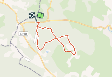
17,6 km | 24 km-effort
5h 28min
![](https://static1.geolcdn.com/siteimages/upload/files/16400158638029165_repeat_loop_refresh_sync_direction_icon.png)
Ja
![Tour Wandern Villecroze - Villecroze de Chapelles en Grottes - Photo](https://media.geolcdn.com/t/375/260/b4f00218-714a-4329-ac66-fe1861cf789d.jpg&format=jpg&maxdim=2)
![Wandern Wandern](https://static1.geolcdn.com/sitytour/trail-icons/101.png)
Villecroze de Chapelles en Grottes
Wandern
Sehr schwierig
Villecroze,
Provence-Alpes-Côte d'Azur,
Var,
France
![](/images/other/stat-length.png)
19,9 km | 28 km-effort
5h 49min
![](https://static1.geolcdn.com/siteimages/upload/files/16400158638029165_repeat_loop_refresh_sync_direction_icon.png)
Ja
![Tour Wandern Tourtour - Tourtour - Les Moulières - Photo](https://media.geolcdn.com/t/375/260/ext.jpg?maxdim=2&url=https%3A%2F%2Fstatic1.geolcdn.com%2Fsiteimages%2Fupload%2Ffiles%2F1553511878bg_sport_marche.png)
![Wandern Wandern](https://static1.geolcdn.com/sitytour/trail-icons/101.png)
Tourtour - Les Moulières
Wandern
Medium
(1)
Tourtour,
Provence-Alpes-Côte d'Azur,
Var,
France
![](/images/other/stat-length.png)
13,1 km | 15,6 km-effort
5h 0min
![](https://static1.geolcdn.com/siteimages/upload/files/16400158638029165_repeat_loop_refresh_sync_direction_icon.png)
Ja
![Tour Andere Aktivitäten Villecroze - fox - Photo](https://media.geolcdn.com/t/375/260/ext.jpg?maxdim=2&url=https%3A%2F%2Fstatic1.geolcdn.com%2Fsiteimages%2Fupload%2Ffiles%2F1545311037marcheuse_200dpi.jpg)
![Andere Aktivitäten Andere Aktivitäten](https://static1.geolcdn.com/sitytour/trail-icons/900.png)
fox
Andere Aktivitäten
Medium
(1)
Villecroze,
Provence-Alpes-Côte d'Azur,
Var,
France
![](/images/other/stat-length.png)
42 km | 52 km-effort
2h 24min
![](https://static1.geolcdn.com/siteimages/upload/files/16400158638029165_repeat_loop_refresh_sync_direction_icon.png)
Ja
![Tour Mountainbike Villecroze - st bart - Photo](https://media.geolcdn.com/t/375/260/ext.jpg?maxdim=2&url=https%3A%2F%2Fstatic1.geolcdn.com%2Fsiteimages%2Fupload%2Ffiles%2F1524743154velo.jpg)
![Mountainbike Mountainbike](https://static1.geolcdn.com/sitytour/trail-icons/202.png)
st bart
Mountainbike
Schwierig
(1)
Villecroze,
Provence-Alpes-Côte d'Azur,
Var,
France
![](/images/other/stat-length.png)
33 km | 42 km-effort
2h 20min
![](https://static1.geolcdn.com/siteimages/upload/files/16400158638029165_repeat_loop_refresh_sync_direction_icon.png)
Ja
![Tour Mountainbike Villecroze - giant vs haibike - Photo](https://media.geolcdn.com/t/375/260/ext.jpg?maxdim=2&url=https%3A%2F%2Fstatic1.geolcdn.com%2Fsiteimages%2Fupload%2Ffiles%2F1524743154velo.jpg)
![Mountainbike Mountainbike](https://static1.geolcdn.com/sitytour/trail-icons/202.png)
giant vs haibike
Mountainbike
Medium
(1)
Villecroze,
Provence-Alpes-Côte d'Azur,
Var,
France
![](/images/other/stat-length.png)
29 km | 36 km-effort
1h 49min
![](https://static1.geolcdn.com/siteimages/upload/files/16400158638029165_repeat_loop_refresh_sync_direction_icon.png)
Ja
![Tour Wandern Villecroze - VILLECROZE TOURTOUR N - Photo](https://media.geolcdn.com/t/375/260/599e5e7e-da69-49e5-8690-f7d254b7e4d2.jpg&format=jpg&maxdim=2)
![Wandern Wandern](https://static1.geolcdn.com/sitytour/trail-icons/101.png)
VILLECROZE TOURTOUR N
Wandern
Sehr schwierig
Villecroze,
Provence-Alpes-Côte d'Azur,
Var,
France
![](/images/other/stat-length.png)
15,1 km | 21 km-effort
4h 33min
![](https://static1.geolcdn.com/siteimages/upload/files/16400158638029165_repeat_loop_refresh_sync_direction_icon.png)
Ja
![Tour Wandern Villecroze - Villecroze- Domaine Saint Jean - Photo](https://media.geolcdn.com/t/375/260/1159e4c7-252a-4789-9dc1-6697f859dafa.jpg&format=jpg&maxdim=2)
![Wandern Wandern](https://static1.geolcdn.com/sitytour/trail-icons/101.png)
Villecroze- Domaine Saint Jean
Wandern
Einfach
Villecroze,
Provence-Alpes-Côte d'Azur,
Var,
France
![](/images/other/stat-length.png)
4,3 km | 5,4 km-effort
1h 16min
![](https://static1.geolcdn.com/siteimages/upload/files/16400158638029165_repeat_loop_refresh_sync_direction_icon.png)
Nein
![Tour sport Saint-Antonin-du-Var - 2024-02-05_17h29m21_st antonin demain - Photo](https://media.geolcdn.com/t/375/260/ext.jpg?maxdim=2&url=https%3A%2F%2Fsecurestorage.geolives.com%2Fsitytour%2Ftrail-bg%2Fdefault.jpg)
2024-02-05_17h29m21_st antonin demain
sport
Sehr leicht
(1)
Saint-Antonin-du-Var,
Provence-Alpes-Côte d'Azur,
Var,
France
![](/images/other/stat-length.png)
27 km | 35 km-effort
Unbekannt
![](https://static1.geolcdn.com/siteimages/upload/files/16400158638029165_repeat_loop_refresh_sync_direction_icon.png)
Ja