![](/images/other/stat-length.png)
![Tour Wandern Kelmis - La Calamine - Sentier didactique et Réserve Naturelle - Photo](https://media.geolcdn.com/t/1900/400/ext.pjpeg?maxdim=2&url=https%3A%2F%2Fstatic1.geolcdn.com%2Fsiteimages%2Fupload%2Ffiles%2F1553511878bg_sport_marche.png)
La Calamine - Sentier didactique et Réserve Naturelle
Michel GUISSE
Benutzer
![Länge](/images/other/stat-length.png)
Länge
8,6 km
![Maximale Höhe](https://static1.geolcdn.com/siteimages/upload/files/1508320355ic_sort_altitude_max_24dp.png)
Maximale Höhe
238 m
![Positive Höhendifferenz](https://static1.geolcdn.com/siteimages/upload/files/1508320355ic_sort_den_pos_24dp.png)
Positive Höhendifferenz
143 m
![Km-Effort](/images/other/stat-length.png)
Km-Effort
10,5 km
![Min. Höhe](https://static1.geolcdn.com/siteimages/upload/files/1508320355ic_sort_altitude_min_24dp.png)
Min. Höhe
170 m
![Negative Höhendifferenz](https://static1.geolcdn.com/siteimages/upload/files/1508320355ic_sort_den_neg_24dp.png)
Negative Höhendifferenz
143 m
![Boucle](https://static1.geolcdn.com/siteimages/upload/files/16400158638029165_repeat_loop_refresh_sync_direction_icon.png)
Boucle
Ja
Erstellungsdatum :
2024-01-23 10:40:28.338
Letzte Änderung :
2024-01-23 10:46:49.129
![Wandern](https://static1.geolcdn.com/sitytour/trail-icons/101.png)
2h23
Schwierigkeit : Medium
![Scannen Sie diesen QR-Code, um die Tour in der SityTrail-Anwendung zu öffnen](https://capi.geolives.com/qq0zvz2zws4bq2lad0pu/sitytour/trails/3924672/qr.png?size=200)
Kostenlosegpshiking-Anwendung
Über SityTrail
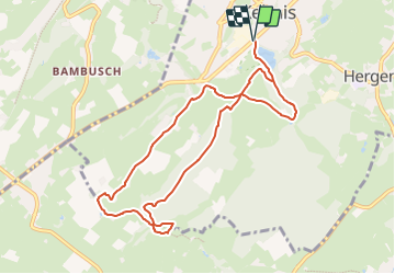
Tour Wandern von 8,6 km verfügbar auf Wallonien, Lüttich, Kelmis. Diese Tour wird von Michel GUISSE vorgeschlagen.
Beschreibung
Un peu de route secondaire, sentiers le long de paysages dégagés et zones forestières. Quelques vestiges de l'activité minière.
Ort
Land:
Belgium
Region :
Wallonien
Abteilung/Provinz :
Lüttich
Kommune :
Kelmis
Standort:
Unknown
Gehen Sie:(Dec)
Gehen Sie:(UTM)
288994 ; 5622132 (32U) N.
Kommentare
Touren in der Umgebung
![Tour Wandern Kelmis - Le pays calaminaire - Photo](https://media.geolcdn.com/t/375/260/30655fe2-e81a-47ed-96f4-20092bed94b7.jpg&format=jpg&maxdim=2)
![Wandern Wandern](https://static1.geolcdn.com/sitytour/trail-icons/101.png)
Le pays calaminaire
Wandern
Medium
(1)
Kelmis,
Wallonien,
Lüttich,
Belgium
![](/images/other/stat-length.png)
9,6 km | 12,1 km-effort
2h 44min
![](https://static1.geolcdn.com/siteimages/upload/files/16400158638029165_repeat_loop_refresh_sync_direction_icon.png)
Ja
![Tour Wandern Kelmis - La Calamine - Photo](https://media.geolcdn.com/t/375/260/606e5792-434a-491a-b5eb-2bfc2ef6f1ed.jpg&format=jpg&maxdim=2)
![Wandern Wandern](https://static1.geolcdn.com/sitytour/trail-icons/101.png)
La Calamine
Wandern
Einfach
(1)
Kelmis,
Wallonien,
Lüttich,
Belgium
![](/images/other/stat-length.png)
9,1 km | 11,6 km-effort
2h 38min
![](https://static1.geolcdn.com/siteimages/upload/files/16400158638029165_repeat_loop_refresh_sync_direction_icon.png)
Ja
![Tour Wandern Aachen - Aix-la-Chapelle - Photo](https://media.geolcdn.com/t/375/260/19678e47-68ef-4997-bad3-67eb75fafd82.jpg&format=jpg&maxdim=2)
![Wandern Wandern](https://static1.geolcdn.com/sitytour/trail-icons/101.png)
Aix-la-Chapelle
Wandern
Einfach
(1)
Aachen,
Nordrhein-Westfalen,
Städteregion Aachen,
Germany
![](/images/other/stat-length.png)
11,4 km | 15,4 km-effort
3h 30min
![](https://static1.geolcdn.com/siteimages/upload/files/16400158638029165_repeat_loop_refresh_sync_direction_icon.png)
Ja
![Tour Wandern Kelmis - 2022-01-18_14h17m25_kelmis - Photo](https://media.geolcdn.com/t/375/260/9eea9d75-ea39-4660-b255-7d2a2255555e.jpg&format=jpg&maxdim=2)
![Wandern Wandern](https://static1.geolcdn.com/sitytour/trail-icons/101.png)
2022-01-18_14h17m25_kelmis
Wandern
Einfach
(1)
Kelmis,
Wallonien,
Lüttich,
Belgium
![](/images/other/stat-length.png)
14,2 km | 18,4 km-effort
4h 10min
![](https://static1.geolcdn.com/siteimages/upload/files/16400158638029165_repeat_loop_refresh_sync_direction_icon.png)
Ja
![Tour Wandern Raeren - 2021-04-02_18h39m41_975 - Photo](https://media.geolcdn.com/t/375/260/4dbde2fb-33e3-4e75-84b3-1404a45e04cc.jpg&format=jpg&maxdim=2)
![Wandern Wandern](https://static1.geolcdn.com/sitytour/trail-icons/101.png)
2021-04-02_18h39m41_975
Wandern
Einfach
(1)
Raeren,
Wallonien,
Lüttich,
Belgium
![](/images/other/stat-length.png)
14,6 km | 17,8 km-effort
4h 2min
![](https://static1.geolcdn.com/siteimages/upload/files/16400158638029165_repeat_loop_refresh_sync_direction_icon.png)
Ja
![Tour Wandern Kelmis - 20200730 - Les 3 Bornes 7.3 Km - Photo](https://media.geolcdn.com/t/375/260/ab7b3f98-4235-4a73-ba70-1bedd5c785f3.jpg&format=jpg&maxdim=2)
![Wandern Wandern](https://static1.geolcdn.com/sitytour/trail-icons/101.png)
20200730 - Les 3 Bornes 7.3 Km
Wandern
Schwierig
(1)
Kelmis,
Wallonien,
Lüttich,
Belgium
![](/images/other/stat-length.png)
7,4 km | 10,4 km-effort
1h 50min
![](https://static1.geolcdn.com/siteimages/upload/files/16400158638029165_repeat_loop_refresh_sync_direction_icon.png)
Ja
![Tour Wandern Kelmis - Venn Trilogie (1er étape) - Photo](https://media.geolcdn.com/t/375/260/1309a595-2e15-4d31-9259-ac0f30e3e1c8.jpg&format=jpg&maxdim=2)
![Wandern Wandern](https://static1.geolcdn.com/sitytour/trail-icons/101.png)
Venn Trilogie (1er étape)
Wandern
Medium
(1)
Kelmis,
Wallonien,
Lüttich,
Belgium
![](/images/other/stat-length.png)
25 km | 30 km-effort
5h 0min
![](https://static1.geolcdn.com/siteimages/upload/files/16400158638029165_repeat_loop_refresh_sync_direction_icon.png)
Nein
![Tour Wandern Raeren - RB-Lg-30_Hauset_via-racc-2 - Photo](https://media.geolcdn.com/t/375/260/ext.jpg?maxdim=2&url=https%3A%2F%2Fservices.sitytrail.com%2FGeolivesWS%2FDownloadMedia.ashx%3FTrailID%3D402105%26Media%3Df4d2b2db-afd2-4d70-8342-c9642a40cdea.jpg)
![Wandern Wandern](https://static1.geolcdn.com/sitytour/trail-icons/101.png)
RB-Lg-30_Hauset_via-racc-2
Wandern
(4)
Raeren,
Wallonien,
Lüttich,
Belgium
![](/images/other/stat-length.png)
13,3 km | 15,9 km-effort
3h 37min
![](https://static1.geolcdn.com/siteimages/upload/files/16400158638029165_repeat_loop_refresh_sync_direction_icon.png)
Ja
![Tour Wandern Raeren - RB-Lg-30_Hauset - Photo](https://media.geolcdn.com/t/375/260/ext.jpg?maxdim=2&url=https%3A%2F%2Fservices.sitytrail.com%2FGeolivesWS%2FDownloadMedia.ashx%3FTrailID%3D402103%26Media%3Df4d2b2db-afd2-4d70-8342-c9642a40cdea.jpg)
![Wandern Wandern](https://static1.geolcdn.com/sitytour/trail-icons/101.png)