![](/images/other/stat-length.png)
![Tour Wandern Flayosc - 2024-01-11 berne reconnue - Photo](https://media.geolcdn.com/t/1900/400/ext.pjpeg?maxdim=2&url=https%3A%2F%2Fstatic1.geolcdn.com%2Fsiteimages%2Fupload%2Ffiles%2F1553511878bg_sport_marche.png)
2024-01-11 berne reconnue
Christianlabourie
Benutzer
![Länge](/images/other/stat-length.png)
Länge
7,3 km
![Maximale Höhe](https://static1.geolcdn.com/siteimages/upload/files/1508320355ic_sort_altitude_max_24dp.png)
Maximale Höhe
326 m
![Positive Höhendifferenz](https://static1.geolcdn.com/siteimages/upload/files/1508320355ic_sort_den_pos_24dp.png)
Positive Höhendifferenz
145 m
![Km-Effort](/images/other/stat-length.png)
Km-Effort
9,2 km
![Min. Höhe](https://static1.geolcdn.com/siteimages/upload/files/1508320355ic_sort_altitude_min_24dp.png)
Min. Höhe
213 m
![Negative Höhendifferenz](https://static1.geolcdn.com/siteimages/upload/files/1508320355ic_sort_den_neg_24dp.png)
Negative Höhendifferenz
147 m
![Boucle](https://static1.geolcdn.com/siteimages/upload/files/16400158638029165_repeat_loop_refresh_sync_direction_icon.png)
Boucle
Ja
Erstellungsdatum :
2024-01-11 08:10:51.963
Letzte Änderung :
2024-01-11 13:39:01.315
![Wandern](https://static1.geolcdn.com/sitytour/trail-icons/101.png)
2h05
Schwierigkeit : Medium
![Scannen Sie diesen QR-Code, um die Tour in der SityTrail-Anwendung zu öffnen](https://capi.geolives.com/qq0zvz2zws4bq2lad0pu/sitytour/trails/3913173/qr.png?size=200)
Kostenlosegpshiking-Anwendung
Über SityTrail
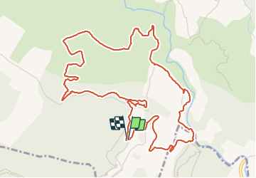
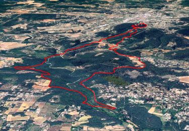
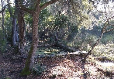
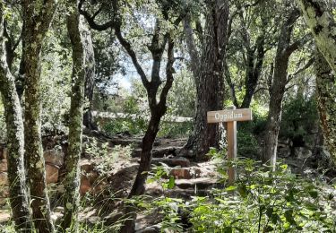
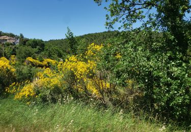
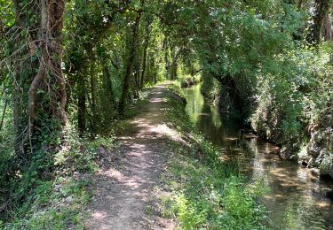
Tour Wandern von 7,3 km verfügbar auf Provence-Alpes-Côte d'Azur, Var, Flayosc. Diese Tour wird von Christianlabourie vorgeschlagen.
Beschreibung
Facile. Dénivelé bien réparti avec au Km une descente de 60m courte comportant des gros cailloux. Quelques petits coups de cul en montée et un fossé pour passer un ru un peu pentu sur 4 m et à sécuriser vers le Km4.
Ort
Land:
France
Region :
Provence-Alpes-Côte d'Azur
Abteilung/Provinz :
Var
Kommune :
Flayosc
Standort:
Unknown
Gehen Sie:(Dec)
Gehen Sie:(UTM)
287002 ; 4821547 (32T) N.
Kommentare
Touren in der Umgebung
![Tour Wandern Flayosc - Flayosc - Photo](https://media.geolcdn.com/t/375/260/ext.jpg?maxdim=2&url=https%3A%2F%2Fstatic1.geolcdn.com%2Fsiteimages%2Fupload%2Ffiles%2F1553511878bg_sport_marche.png)
![Wandern Wandern](https://static1.geolcdn.com/sitytour/trail-icons/101.png)
Flayosc
Wandern
Einfach
(4)
Flayosc,
Provence-Alpes-Côte d'Azur,
Var,
France
![](/images/other/stat-length.png)
8,3 km | 10,6 km-effort
2h 18min
![](https://static1.geolcdn.com/siteimages/upload/files/16400158638029165_repeat_loop_refresh_sync_direction_icon.png)
Ja
![Tour Wandern Lorgues - SityTrail - Le hameau de Sauveclare - Photo](https://media.geolcdn.com/t/375/260/bc0b058e-af96-4d28-bc15-d4c1c9d787b7.jpg&format=jpg&maxdim=2)
![Wandern Wandern](https://static1.geolcdn.com/sitytour/trail-icons/101.png)
SityTrail - Le hameau de Sauveclare
Wandern
Einfach
Lorgues,
Provence-Alpes-Côte d'Azur,
Var,
France
![](/images/other/stat-length.png)
14,2 km | 20 km-effort
6h 0min
![](https://static1.geolcdn.com/siteimages/upload/files/16400158638029165_repeat_loop_refresh_sync_direction_icon.png)
Ja
![Tour Wandern Lorgues - Lorgues et l'Ermitage Saint-Ferréol - Photo](https://media.geolcdn.com/t/375/260/e62c5b83-8a2e-4772-82d8-7fdc4c20c935.jpg&format=jpg&maxdim=2)
![Wandern Wandern](https://static1.geolcdn.com/sitytour/trail-icons/101.png)
Lorgues et l'Ermitage Saint-Ferréol
Wandern
Medium
Lorgues,
Provence-Alpes-Côte d'Azur,
Var,
France
![](/images/other/stat-length.png)
5,5 km | 8 km-effort
1h 48min
![](https://static1.geolcdn.com/siteimages/upload/files/16400158638029165_repeat_loop_refresh_sync_direction_icon.png)
Ja
![Tour Wandern Draguignan - Rebouillon le long de la Nartuby - Photo](https://media.geolcdn.com/t/375/260/5546167f-335f-4958-9f3e-7305fd054196.jpg&format=jpg&maxdim=2)
![Wandern Wandern](https://static1.geolcdn.com/sitytour/trail-icons/101.png)
Rebouillon le long de la Nartuby
Wandern
Einfach
Draguignan,
Provence-Alpes-Côte d'Azur,
Var,
France
![](/images/other/stat-length.png)
4,8 km | 5,9 km-effort
1h 33min
![](https://static1.geolcdn.com/siteimages/upload/files/16400158638029165_repeat_loop_refresh_sync_direction_icon.png)
Ja
![Tour Wandern Flayosc - 20210922 Berne3 les Oussiayes - Photo](https://media.geolcdn.com/t/375/260/63a967ae-524a-431f-b327-781a014fa426.jpg&format=jpg&maxdim=2)
![Wandern Wandern](https://static1.geolcdn.com/sitytour/trail-icons/101.png)
20210922 Berne3 les Oussiayes
Wandern
Medium
Flayosc,
Provence-Alpes-Côte d'Azur,
Var,
France
![](/images/other/stat-length.png)
11,5 km | 14,8 km-effort
4h 39min
![](https://static1.geolcdn.com/siteimages/upload/files/16400158638029165_repeat_loop_refresh_sync_direction_icon.png)
Ja
![Tour Wandern Lorgues - 20190130 Mentone Est rando réelle. - Photo](https://media.geolcdn.com/t/375/260/ext.jpg?maxdim=2&url=https%3A%2F%2Fservices.sitytrail.com%2FGeolivesWS%2FDownloadMedia.ashx%3FTrailID%3D1104083%26Media%3Dfix__20190130105141.jpg)
![Wandern Wandern](https://static1.geolcdn.com/sitytour/trail-icons/101.png)
20190130 Mentone Est rando réelle.
Wandern
Einfach
Lorgues,
Provence-Alpes-Côte d'Azur,
Var,
France
![](/images/other/stat-length.png)
17,4 km | 22 km-effort
4h 40min
![](https://static1.geolcdn.com/siteimages/upload/files/16400158638029165_repeat_loop_refresh_sync_direction_icon.png)
Ja
![Tour Wandern Lorgues - Lorgues - sentier découverte Saint-Ferréol - Photo](https://media.geolcdn.com/t/375/260/45684484-d312-4a9e-82bd-16f54a0668a9.jpg&format=jpg&maxdim=2)
![Wandern Wandern](https://static1.geolcdn.com/sitytour/trail-icons/101.png)
Lorgues - sentier découverte Saint-Ferréol
Wandern
Einfach
Lorgues,
Provence-Alpes-Côte d'Azur,
Var,
France
![](/images/other/stat-length.png)
2,6 km | 3,8 km-effort
1h 3min
![](https://static1.geolcdn.com/siteimages/upload/files/16400158638029165_repeat_loop_refresh_sync_direction_icon.png)
Ja
![Tour Wandern Flayosc -](https://media.geolcdn.com/t/375/260/83c7696e-952a-48f5-bea9-fa5ceec23ba1.jpg&format=jpg&maxdim=2)
![Wandern Wandern](https://static1.geolcdn.com/sitytour/trail-icons/101.png)
"Les Peylons"
Wandern
Medium
Flayosc,
Provence-Alpes-Côte d'Azur,
Var,
France
![](/images/other/stat-length.png)
9 km | 11,4 km-effort
2h 35min
![](https://static1.geolcdn.com/siteimages/upload/files/16400158638029165_repeat_loop_refresh_sync_direction_icon.png)
Ja
![Tour sport Lorgues - Tour St Jaumes pont d’argens thoronet - Photo](https://media.geolcdn.com/t/375/260/da27d9c9-7a62-4565-93c2-e4ae64855591.jpg&format=jpg&maxdim=2)
Tour St Jaumes pont d’argens thoronet
sport
Sehr leicht
Lorgues,
Provence-Alpes-Côte d'Azur,
Var,
France
![](/images/other/stat-length.png)
18,1 km | 23 km-effort
Unbekannt
![](https://static1.geolcdn.com/siteimages/upload/files/16400158638029165_repeat_loop_refresh_sync_direction_icon.png)
Ja