![](/images/other/stat-length.png)
![Tour Schneeschuhwandern Camurac - RQ-Camurac Le Pla de l'Homme - Photo](https://media.geolcdn.com/t/1900/400/ext.pjpeg?maxdim=2&url=https%3A%2F%2Fstatic1.geolcdn.com%2Fsiteimages%2Fupload%2Ffiles%2F1524743153raquette.jpg)
RQ-Camurac Le Pla de l'Homme
Polo-31
Benutzer
![Länge](/images/other/stat-length.png)
![Maximale Höhe](https://static1.geolcdn.com/siteimages/upload/files/1508320355ic_sort_altitude_max_24dp.png)
![Positive Höhendifferenz](https://static1.geolcdn.com/siteimages/upload/files/1508320355ic_sort_den_pos_24dp.png)
![Km-Effort](/images/other/stat-length.png)
![Min. Höhe](https://static1.geolcdn.com/siteimages/upload/files/1508320355ic_sort_altitude_min_24dp.png)
![Negative Höhendifferenz](https://static1.geolcdn.com/siteimages/upload/files/1508320355ic_sort_den_neg_24dp.png)
![Boucle](https://static1.geolcdn.com/siteimages/upload/files/16400158638029165_repeat_loop_refresh_sync_direction_icon.png)
![Schneeschuhwandern](https://static1.geolcdn.com/sitytour/trail-icons/504.png)
1h30
Schwierigkeit : Unbekannt
![Scannen Sie diesen QR-Code, um die Tour in der SityTrail-Anwendung zu öffnen](https://capi.geolives.com/qq0zvz2zws4bq2lad0pu/sitytour/trails/388550/qr.png?size=200)
Kostenlosegpshiking-Anwendung
Über SityTrail
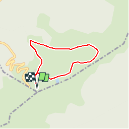
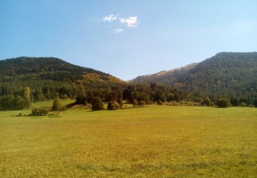
Tour Schneeschuhwandern von 3 km verfügbar auf Okzitanien, Aude, Camurac. Diese Tour wird von Polo-31 vorgeschlagen.
Beschreibung
Cinq mètres après le garage des dameuses, un panneau bleu indique le "Pla de l'Homme". Aller jusqu'à la cabane "Mon Caprice". Suivre le parcours vers l'est, on passe le Téléski puis on contourne à 180° le Pla de l'homme. Remonter vers le Sarrat de Picaucel qu'on laisse à droite et rejoindre la station.
Ort
Kommentare
Touren in der Umgebung
![Tour Wandern Prades - Pic Fourcat Prades - Photo](https://media.geolcdn.com/t/375/260/7328a631-1f70-4385-b122-8064227fbc3d.jpg&format=jpg&maxdim=2)
![Wandern Wandern](https://static1.geolcdn.com/sitytour/trail-icons/101.png)
Wandern
![](/images/other/stat-length.png)
![](https://static1.geolcdn.com/siteimages/upload/files/16400158638029165_repeat_loop_refresh_sync_direction_icon.png)
![Tour Wandern Ascou - Crête de Pailhères & Sarrat des Chèvres- Pic de Tarbesou - Photo](https://media.geolcdn.com/t/375/260/f1e23bb8-f7f7-4e4f-8a11-193e7164ca9f.jpg&format=jpg&maxdim=2)
![Wandern Wandern](https://static1.geolcdn.com/sitytour/trail-icons/101.png)
Wandern
![](/images/other/stat-length.png)
![](https://static1.geolcdn.com/siteimages/upload/files/16400158638029165_repeat_loop_refresh_sync_direction_icon.png)
![Tour Schneeschuhwandern Montaillou - Montaillou - Quercourt - Cassaula - Photo](https://media.geolcdn.com/t/375/260/77edc5f4-b2bc-4200-8c88-de065acc055d.jpg&format=jpg&maxdim=2)
![Schneeschuhwandern Schneeschuhwandern](https://static1.geolcdn.com/sitytour/trail-icons/504.png)
Schneeschuhwandern
![](/images/other/stat-length.png)
![](https://static1.geolcdn.com/siteimages/upload/files/16400158638029165_repeat_loop_refresh_sync_direction_icon.png)
![Tour Wandern La Fajolle - La forêt de La Fajolle - Photo](https://media.geolcdn.com/t/375/260/e6a5165b-43e1-4511-879f-4d2d537ffb0b.jpg&format=jpg&maxdim=2)
![Wandern Wandern](https://static1.geolcdn.com/sitytour/trail-icons/101.png)
Wandern
![](/images/other/stat-length.png)
![](https://static1.geolcdn.com/siteimages/upload/files/16400158638029165_repeat_loop_refresh_sync_direction_icon.png)
![Tour Wandern Camurac - Les cretes de Camurac 2021 - Photo](https://media.geolcdn.com/t/375/260/5d50d82b-2d5f-4a5c-b7c9-2ca11180f548.jpg&format=jpg&maxdim=2)
![Wandern Wandern](https://static1.geolcdn.com/sitytour/trail-icons/101.png)
Wandern
![](/images/other/stat-length.png)
![](https://static1.geolcdn.com/siteimages/upload/files/16400158638029165_repeat_loop_refresh_sync_direction_icon.png)
![Tour Wandern Ascou - boucle autour du pic de tabersou et du pic de l ours - Photo](https://media.geolcdn.com/t/375/260/354f6e97-2a91-4ef1-9763-9e3f8f85838c.jpg&format=jpg&maxdim=2)
![Wandern Wandern](https://static1.geolcdn.com/sitytour/trail-icons/101.png)
Wandern
![](/images/other/stat-length.png)
![](https://static1.geolcdn.com/siteimages/upload/files/16400158638029165_repeat_loop_refresh_sync_direction_icon.png)
![Tour Wandern Camurac - Les sept frères - Photo](https://media.geolcdn.com/t/375/260/930344b5-c8d1-433a-8942-f0db24583848.jpg&format=jpg&maxdim=2)
![Wandern Wandern](https://static1.geolcdn.com/sitytour/trail-icons/101.png)
Wandern
![](/images/other/stat-length.png)
![](https://static1.geolcdn.com/siteimages/upload/files/16400158638029165_repeat_loop_refresh_sync_direction_icon.png)
![Tour Wandern Camurac - Tour du Boum - Photo](https://media.geolcdn.com/t/375/260/f82072ee-8895-43c7-93a7-3d8b770c547f.jpg&format=jpg&maxdim=2)
![Wandern Wandern](https://static1.geolcdn.com/sitytour/trail-icons/101.png)
![Tour Wandern Camurac - les crêtes de Camurac - Photo](https://media.geolcdn.com/t/375/260/0e23b182-c13b-4448-ac03-8af9a97bb651.jpg&format=jpg&maxdim=2)
![Wandern Wandern](https://static1.geolcdn.com/sitytour/trail-icons/101.png)
Wandern
![](/images/other/stat-length.png)
![](https://static1.geolcdn.com/siteimages/upload/files/16400158638029165_repeat_loop_refresh_sync_direction_icon.png)