![](/images/other/stat-length.png)
![Tour Wandern Yvoir - Marche ADEPS Spontin - Photo](https://media.geolcdn.com/t/1900/400/ca11b33b-c1df-4fcc-88f9-5ade184cd470.jpg&format=pjpeg&maxdim=2)
Marche ADEPS Spontin
Michel1963
Benutzer GUIDE
![Länge](/images/other/stat-length.png)
Länge
14,4 km
![Maximale Höhe](https://static1.geolcdn.com/siteimages/upload/files/1508320355ic_sort_altitude_max_24dp.png)
Maximale Höhe
279 m
![Positive Höhendifferenz](https://static1.geolcdn.com/siteimages/upload/files/1508320355ic_sort_den_pos_24dp.png)
Positive Höhendifferenz
312 m
![Km-Effort](/images/other/stat-length.png)
Km-Effort
18,6 km
![Min. Höhe](https://static1.geolcdn.com/siteimages/upload/files/1508320355ic_sort_altitude_min_24dp.png)
Min. Höhe
151 m
![Negative Höhendifferenz](https://static1.geolcdn.com/siteimages/upload/files/1508320355ic_sort_den_neg_24dp.png)
Negative Höhendifferenz
313 m
![Boucle](https://static1.geolcdn.com/siteimages/upload/files/16400158638029165_repeat_loop_refresh_sync_direction_icon.png)
Boucle
Ja
Erstellungsdatum :
2023-12-03 08:43:58.819
Letzte Änderung :
2023-12-05 12:40:10.416
![Wandern](https://static1.geolcdn.com/sitytour/trail-icons/101.png)
3h04
Schwierigkeit : Medium
![Scannen Sie diesen QR-Code, um die Tour in der SityTrail-Anwendung zu öffnen](https://capi.geolives.com/qq0zvz2zws4bq2lad0pu/sitytour/trails/3883709/qr.png?size=200)
Kostenlosegpshiking-Anwendung
Über SityTrail
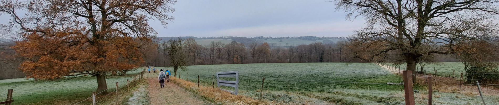
Tour Wandern von 14,4 km verfügbar auf Wallonien, Namur, Yvoir. Diese Tour wird von Michel1963 vorgeschlagen.
Beschreibung
ATTENTION : Vers le km 10.7, le chemin rentre dans le domaine VIVAQUA et devrait donc être normalement fermé (exception faite pour la marche ADEPS !).
Il faudra alors emprunté le chemin de grande randonnée GR 575 balisé blanc et rouge.
Ort
Land:
Belgium
Region :
Wallonien
Abteilung/Provinz :
Namur
Kommune :
Yvoir
Standort:
Unknown
Gehen Sie:(Dec)
Gehen Sie:(UTM)
643065 ; 5576475 (31U) N.
Kommentare
Touren in der Umgebung
![Tour Wandern Assesse - RB-Na-02 Raccourci - Les collines de la vallée du Bocq - Photo](https://media.geolcdn.com/t/375/260/ext.jpg?maxdim=2&url=https%3A%2F%2Fservices.sitytrail.com%2FGeolivesWS%2FDownloadMedia.ashx%3FTrailID%3D794014%26Media%3Dc4c97e29-7bfb-495c-ae56-13528ce8d0b3.JPG)
![Wandern Wandern](https://static1.geolcdn.com/sitytour/trail-icons/101.png)
RB-Na-02 Raccourci - Les collines de la vallée du Bocq
Wandern
Medium
(7)
Assesse,
Wallonien,
Namur,
Belgium
![](/images/other/stat-length.png)
17 km | 23 km-effort
5h 32min
![](https://static1.geolcdn.com/siteimages/upload/files/16400158638029165_repeat_loop_refresh_sync_direction_icon.png)
Ja
![Tour Wandern Ciney - CINEY- Braibant- Promenade du Bois des Aunes - Photo](https://media.geolcdn.com/t/375/260/ext.jpg?maxdim=2&url=https%3A%2F%2Fservices.sitytrail.com%2FGeolivesWS%2FDownloadMedia.ashx%3FTrailID%3D250670%26Media%3Dc1b852e3-9355-4183-b02e-f01426a46975.JPG)
![Wandern Wandern](https://static1.geolcdn.com/sitytour/trail-icons/101.png)
CINEY- Braibant- Promenade du Bois des Aunes
Wandern
Einfach
(11)
Ciney,
Wallonien,
Namur,
Belgium
![](/images/other/stat-length.png)
6,8 km | 8,7 km-effort
1h 53min
![](https://static1.geolcdn.com/siteimages/upload/files/16400158638029165_repeat_loop_refresh_sync_direction_icon.png)
Ja
![Tour Wandern Assesse - RB-Na-02 Les collines de la vallée du Bocq - Photo](https://media.geolcdn.com/t/375/260/ext.jpg?maxdim=2&url=https%3A%2F%2Fservices.sitytrail.com%2FGeolivesWS%2FDownloadMedia.ashx%3FTrailID%3D250531%26Media%3Dc4c97e29-7bfb-495c-ae56-13528ce8d0b3.JPG)
![Wandern Wandern](https://static1.geolcdn.com/sitytour/trail-icons/101.png)
RB-Na-02 Les collines de la vallée du Bocq
Wandern
Medium
(21)
Assesse,
Wallonien,
Namur,
Belgium
![](/images/other/stat-length.png)
21 km | 28 km-effort
5h 32min
![](https://static1.geolcdn.com/siteimages/upload/files/16400158638029165_repeat_loop_refresh_sync_direction_icon.png)
Ja
![Tour Wandern Assesse - 05 Paysage condruzien - Photo](https://media.geolcdn.com/t/375/260/ext.jpg?maxdim=2&url=https%3A%2F%2Fservices.sitytrail.com%2FGeolivesWS%2FDownloadMedia.ashx%3FTrailID%3D121392%26Media%3D31d83d0c-5bcd-44cd-b8d6-1cc6a3d25bf9.jpg)
![Wandern Wandern](https://static1.geolcdn.com/sitytour/trail-icons/101.png)
05 Paysage condruzien
Wandern
Einfach
(5)
Assesse,
Wallonien,
Namur,
Belgium
![](/images/other/stat-length.png)
10,2 km | 13,3 km-effort
2h 11min
![](https://static1.geolcdn.com/siteimages/upload/files/16400158638029165_repeat_loop_refresh_sync_direction_icon.png)
Nein
![Tour Wandern Assesse - Promenade à Crupet - Photo](https://media.geolcdn.com/t/375/260/ext.jpg?maxdim=2&url=https%3A%2F%2Fservices.sitytrail.com%2FGeolivesWS%2FDownloadMedia.ashx%3FTrailID%3D532928%26Media%3De78ba70e-0d4d-4d8c-b509-37ad32b8d33e.jpg)
![Wandern Wandern](https://static1.geolcdn.com/sitytour/trail-icons/101.png)
Promenade à Crupet
Wandern
Einfach
(3)
Assesse,
Wallonien,
Namur,
Belgium
![](/images/other/stat-length.png)
8,3 km | 11,4 km-effort
2h 30min
![](https://static1.geolcdn.com/siteimages/upload/files/16400158638029165_repeat_loop_refresh_sync_direction_icon.png)
Ja
![Tour Wandern Yvoir - Balade à Spontin - Photo](https://media.geolcdn.com/t/375/260/ext.jpg?maxdim=2&url=https%3A%2F%2Fservices.sitytrail.com%2FGeolivesWS%2FDownloadMedia.ashx%3FTrailID%3D437057%26Media%3D4788e304-dd7c-47cc-a067-745c9f490e74.JPG)
![Wandern Wandern](https://static1.geolcdn.com/sitytour/trail-icons/101.png)
Balade à Spontin
Wandern
Sehr leicht
(4)
Yvoir,
Wallonien,
Namur,
Belgium
![](/images/other/stat-length.png)
5 km | 6,2 km-effort
1h 20min
![](https://static1.geolcdn.com/siteimages/upload/files/16400158638029165_repeat_loop_refresh_sync_direction_icon.png)
Ja
![Tour Wandern Assesse - Bossen en valleien rond Crupet - Photo](https://media.geolcdn.com/t/375/260/ext.jpg?maxdim=2&url=https%3A%2F%2Fservices.sitytrail.com%2FGeolivesWS%2FDownloadMedia.ashx%3FTrailID%3D376655%26Media%3D48beab83-0bce-4d8a-9584-b92792914cfd.JPG)
![Wandern Wandern](https://static1.geolcdn.com/sitytour/trail-icons/101.png)
Bossen en valleien rond Crupet
Wandern
Medium
(3)
Assesse,
Wallonien,
Namur,
Belgium
![](/images/other/stat-length.png)
8,1 km | 11,5 km-effort
2h 25min
![](https://static1.geolcdn.com/siteimages/upload/files/16400158638029165_repeat_loop_refresh_sync_direction_icon.png)
Ja
![Tour Wandern Ciney - CINEY- Sovet- Promenade de la Chapelle de Jet - Photo](https://media.geolcdn.com/t/375/260/ext.jpg?maxdim=2&url=https%3A%2F%2Fservices.sitytrail.com%2FGeolivesWS%2FDownloadMedia.ashx%3FTrailID%3D250703%26Media%3Da960eafd-7fe9-4ce6-854f-8ccad456b86e.JPG)
![Wandern Wandern](https://static1.geolcdn.com/sitytour/trail-icons/101.png)
CINEY- Sovet- Promenade de la Chapelle de Jet
Wandern
Sehr leicht
(2)
Ciney,
Wallonien,
Namur,
Belgium
![](/images/other/stat-length.png)
7,2 km | 8,9 km-effort
1h 52min
![](https://static1.geolcdn.com/siteimages/upload/files/16400158638029165_repeat_loop_refresh_sync_direction_icon.png)
Ja
![Tour Wandern Hamois - HAMOIS-Natoye- Promenade de Natoye Ouest - Photo](https://media.geolcdn.com/t/375/260/ext.jpg?maxdim=2&url=https%3A%2F%2Fservices.sitytrail.com%2FGeolivesWS%2FDownloadMedia.ashx%3FTrailID%3D250692%26Media%3D8540db91-68d8-49c2-ad91-560e8e589f5a.JPG)
![Wandern Wandern](https://static1.geolcdn.com/sitytour/trail-icons/101.png)
HAMOIS-Natoye- Promenade de Natoye Ouest
Wandern
Sehr leicht
(1)
Hamois,
Wallonien,
Namur,
Belgium
![](/images/other/stat-length.png)
10,4 km | 12,7 km-effort
2h 33min
![](https://static1.geolcdn.com/siteimages/upload/files/16400158638029165_repeat_loop_refresh_sync_direction_icon.png)
Ja