![](/images/other/stat-length.png)
![Tour Wandern Saint-Martin-du-Mont - La Bocquette et les gorges du Suran - Photo](https://media.geolcdn.com/t/1900/400/ext.pjpeg?maxdim=2&url=https%3A%2F%2Fstatic1.geolcdn.com%2Fsiteimages%2Fupload%2Ffiles%2F1553511878bg_sport_marche.png)
La Bocquette et les gorges du Suran
adelore
Benutzer
![Länge](/images/other/stat-length.png)
![Maximale Höhe](https://static1.geolcdn.com/siteimages/upload/files/1508320355ic_sort_altitude_max_24dp.png)
![Positive Höhendifferenz](https://static1.geolcdn.com/siteimages/upload/files/1508320355ic_sort_den_pos_24dp.png)
![Km-Effort](/images/other/stat-length.png)
![Min. Höhe](https://static1.geolcdn.com/siteimages/upload/files/1508320355ic_sort_altitude_min_24dp.png)
![Negative Höhendifferenz](https://static1.geolcdn.com/siteimages/upload/files/1508320355ic_sort_den_neg_24dp.png)
![Boucle](https://static1.geolcdn.com/siteimages/upload/files/16400158638029165_repeat_loop_refresh_sync_direction_icon.png)
![Wandern](https://static1.geolcdn.com/sitytour/trail-icons/101.png)
3h43
Schwierigkeit : Schwierig
![Scannen Sie diesen QR-Code, um die Tour in der SityTrail-Anwendung zu öffnen](https://capi.geolives.com/qq0zvz2zws4bq2lad0pu/sitytour/trails/3876571/qr.png?size=200)
Kostenlosegpshiking-Anwendung
Über SityTrail
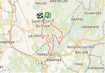
Tour Wandern von 12 km verfügbar auf Auvergne-Rhone-Alpen, Ain, Saint-Martin-du-Mont. Diese Tour wird von adelore vorgeschlagen.
Beschreibung
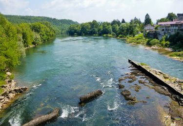
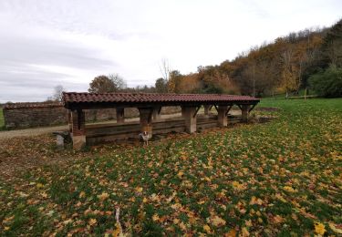
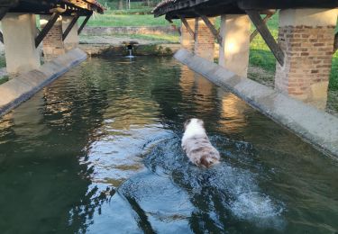
Depuis les vignes revermontoises de St Martin, on imagine pas que le sentier se fraie un passage le long des gorges du Suran dans une nature grandiose entre eau limpide et abri sous roche.Au menu, une variété de paysages jusqu'au sommet du Mt de la Vavre<br /><br />Circuit n°45Les itinéraires proposés sont très diversifiés : Circuits boisés de Taluel, de Plamont et des Monts. Ascension de la Croix de la Dent (555m) où vous pourrez admirer un panorama exceptionnel sur la chaîne des Alpes et le Bugey.Site préhistorique de la Bocquette près des eaux limpides du Suran. (grotte, menhir et lierre multi-centenaire)Montée au Mont Turgon et son fameux coq (343m) où vous aurez une vue magnifique sur le Bugey, la Bresse et la Dombes.Une découverte de paysages contrastés sans oublier les hameaux de Gravelles et de Soblay.Vous pourrez aussi déguster nos vins pétillants, issus des cépages Poulsard et Gamay, appréciés pour leur bouquet et leurs arômes.
Ort
Kommentare
Touren in der Umgebung
![Tour Mountainbike Tossiat - 15-04-13 - Photo](https://media.geolcdn.com/t/375/260/ext.jpg?maxdim=2&url=https%3A%2F%2Fstatic1.geolcdn.com%2Fsiteimages%2Fupload%2Ffiles%2F1524743154velo.jpg)
![Mountainbike Mountainbike](https://static1.geolcdn.com/sitytour/trail-icons/202.png)
Mountainbike
![](/images/other/stat-length.png)
![](https://static1.geolcdn.com/siteimages/upload/files/16400158638029165_repeat_loop_refresh_sync_direction_icon.png)
![Tour Wandern Saint-Martin-du-Mont - St martin du mont - Photo](https://media.geolcdn.com/t/375/260/ext.jpg?maxdim=2&url=https%3A%2F%2Fstatic1.geolcdn.com%2Fsiteimages%2Fupload%2Ffiles%2F1553511878bg_sport_marche.png)
![Wandern Wandern](https://static1.geolcdn.com/sitytour/trail-icons/101.png)
Wandern
![](/images/other/stat-length.png)
![](https://static1.geolcdn.com/siteimages/upload/files/16400158638029165_repeat_loop_refresh_sync_direction_icon.png)
![Tour Wandern Journans - journans - Photo](https://media.geolcdn.com/t/375/260/61f4215e-0e72-412f-b8a5-fca9efa76a72.jpg&format=jpg&maxdim=2)
![Wandern Wandern](https://static1.geolcdn.com/sitytour/trail-icons/101.png)
Wandern
![](/images/other/stat-length.png)
![](https://static1.geolcdn.com/siteimages/upload/files/16400158638029165_repeat_loop_refresh_sync_direction_icon.png)
![Tour Wandern Saint-Martin-du-Mont - Saint Martin du mont - Photo](https://media.geolcdn.com/t/375/260/6be56ac7-5da9-44b1-a422-c0451c6899db.jpg&format=jpg&maxdim=2)
![Wandern Wandern](https://static1.geolcdn.com/sitytour/trail-icons/101.png)
Wandern
![](/images/other/stat-length.png)
![](https://static1.geolcdn.com/siteimages/upload/files/16400158638029165_repeat_loop_refresh_sync_direction_icon.png)
![Tour Wandern Jujurieux - Rando bugiste - Chenavel - Photo](https://media.geolcdn.com/t/375/260/ext.jpg?maxdim=2&url=https%3A%2F%2Fservices.sitytrail.com%2FGeolivesWS%2FDownloadMedia.ashx%3FTrailID%3D215085%26Media%3D15659_2.jpg)
![Wandern Wandern](https://static1.geolcdn.com/sitytour/trail-icons/101.png)
Wandern
![](/images/other/stat-length.png)
![](https://static1.geolcdn.com/siteimages/upload/files/16400158638029165_repeat_loop_refresh_sync_direction_icon.png)
![Tour Pfad Tossiat - lavoir tossiat / journans / senissiat/ X de rignat /lavoir - Photo](https://media.geolcdn.com/t/375/260/baebe044-ba7f-4c89-85ea-5c9074462d9e.jpg&format=jpg&maxdim=2)
![Pfad Pfad](https://static1.geolcdn.com/sitytour/trail-icons/104.png)
Pfad
![](/images/other/stat-length.png)
![](https://static1.geolcdn.com/siteimages/upload/files/16400158638029165_repeat_loop_refresh_sync_direction_icon.png)
![Tour Pfad Tossiat - lavoir tossiat- rignat-lavoir tossiat - Photo](https://media.geolcdn.com/t/375/260/238592c8-685c-4900-9818-b89fa5a681e6.jpg&format=jpg&maxdim=2)
![Pfad Pfad](https://static1.geolcdn.com/sitytour/trail-icons/104.png)
Pfad
![](/images/other/stat-length.png)
![](https://static1.geolcdn.com/siteimages/upload/files/16400158638029165_repeat_loop_refresh_sync_direction_icon.png)
![Tour Wandern Saint-Martin-du-Mont - St Martin du Mont-17674091 - Photo](https://media.geolcdn.com/t/375/260/ext.jpg?maxdim=2&url=https%3A%2F%2Fstatic1.geolcdn.com%2Fsiteimages%2Fupload%2Ffiles%2F1553511878bg_sport_marche.png)
![Wandern Wandern](https://static1.geolcdn.com/sitytour/trail-icons/101.png)
Wandern
![](/images/other/stat-length.png)
![](https://static1.geolcdn.com/siteimages/upload/files/16400158638029165_repeat_loop_refresh_sync_direction_icon.png)
![Tour Zu Fuß Certines - Certines 01 - Photo](https://media.geolcdn.com/t/375/260/ext.jpg?maxdim=2&url=https%3A%2F%2Fstatic1.geolcdn.com%2Fsiteimages%2Fupload%2Ffiles%2F1545311037marcheuse_200dpi.jpg)
![Zu Fuß Zu Fuß](https://static1.geolcdn.com/sitytour/trail-icons/100.png)
Zu Fuß
![](/images/other/stat-length.png)
![](https://static1.geolcdn.com/siteimages/upload/files/16400158638029165_repeat_loop_refresh_sync_direction_icon.png)