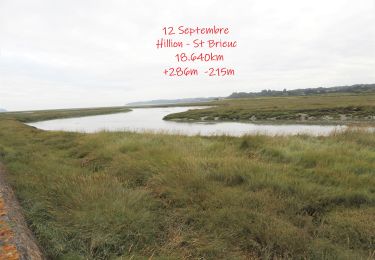
![](/images/other/stat-length.png)
![Tour Wandern Hillion - Hillion Les panoramas 18km - Photo](https://media.geolcdn.com/t/1900/400/ext.pjpeg?maxdim=2&url=https%3A%2F%2Fstatic1.geolcdn.com%2Fsiteimages%2Fupload%2Ffiles%2F1553511878bg_sport_marche.png)
Hillion Les panoramas 18km
dmj41
Benutzer
![Länge](/images/other/stat-length.png)
![Maximale Höhe](https://static1.geolcdn.com/siteimages/upload/files/1508320355ic_sort_altitude_max_24dp.png)
![Positive Höhendifferenz](https://static1.geolcdn.com/siteimages/upload/files/1508320355ic_sort_den_pos_24dp.png)
![Km-Effort](/images/other/stat-length.png)
![Min. Höhe](https://static1.geolcdn.com/siteimages/upload/files/1508320355ic_sort_altitude_min_24dp.png)
![Negative Höhendifferenz](https://static1.geolcdn.com/siteimages/upload/files/1508320355ic_sort_den_neg_24dp.png)
![Boucle](https://static1.geolcdn.com/siteimages/upload/files/16400158638029165_repeat_loop_refresh_sync_direction_icon.png)
![Wandern](https://static1.geolcdn.com/sitytour/trail-icons/101.png)
4h50
Schwierigkeit : Sehr schwierig
![Scannen Sie diesen QR-Code, um die Tour in der SityTrail-Anwendung zu öffnen](https://capi.geolives.com/qq0zvz2zws4bq2lad0pu/sitytour/trails/3857777/qr.png?size=200)
Kostenlosegpshiking-Anwendung
Über SityTrail
Tour Wandern von 17,7 km verfügbar auf Bretagne, Côtes-d'Armor, Hillion. Diese Tour wird von dmj41 vorgeschlagen.
Beschreibung
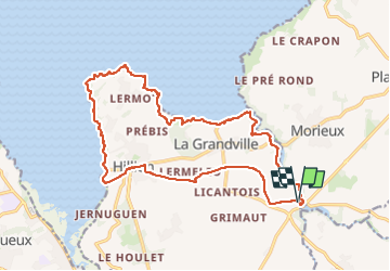
Boucle sur la pointe d'Hillion
Départ / Arrivée : Parking face au 16 rue du Viaduc 22120 Hillion
(près du viaduc des Ponts Neufs)
Passage par la petite ville d'Hillion (Côtes d'Armor)
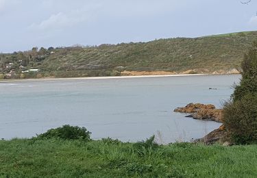
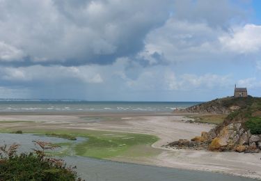
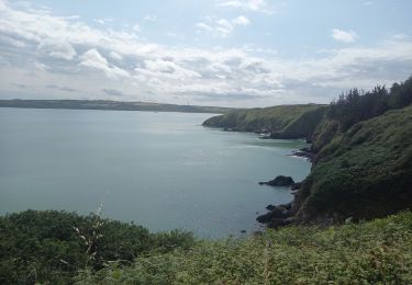
puis on emprunte le GR34 pour longer la côté face à la Baie de St Brieuc
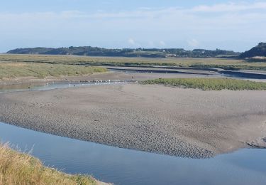
(Possibilité de faire une halte à la Maison de la Baie (à une cinquantaire de mètres du GR34)
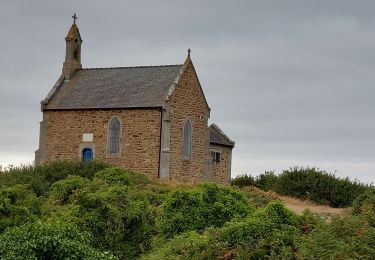
La Pointe du Grouin, la Pointe des Guettes
Puis on redescend (toujours par le GR34) face à l'anse de Morieux, en passant par les plages de Lermot, Bon Abri, de la Grandville
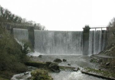
A l'embouchure du Gouessant, on remonte alors de fleuve côtier, toujours par le GR34, jusqu'au niveau du barrage de la centrale hydroélectrique de Pont Roland/
On quitte alors le GR34 (qui lui va traverser le Gouessant) pour continuer à longer le fleuve en empruntant un PR qui permet de rejoindre le viaduc des Ponts Neufs.
Ort
Kommentare
Touren in der Umgebung
![Wandern Wandern](https://static1.geolcdn.com/sitytour/trail-icons/101.png)
Wandern
![](/images/other/stat-length.png)
![](https://static1.geolcdn.com/siteimages/upload/files/16400158638029165_repeat_loop_refresh_sync_direction_icon.png)
![Tour Fahrrad Yffiniac - 9 - Yffiniac / Saint-Brieuc - Photo](https://media.geolcdn.com/t/375/260/ext.jpg?maxdim=2&url=https%3A%2F%2Fstatic1.geolcdn.com%2Fsiteimages%2Fupload%2Ffiles%2F1524743154velo.jpg)
![Fahrrad Fahrrad](https://static1.geolcdn.com/sitytour/trail-icons/200.png)
Fahrrad
![](/images/other/stat-length.png)
![](https://static1.geolcdn.com/siteimages/upload/files/16400158638029165_repeat_loop_refresh_sync_direction_icon.png)
![Tour Wandern Hillion - Hillion - Photo](https://media.geolcdn.com/t/375/260/5f86b00a-294e-442a-9394-58fb975dda85.jpg&format=jpg&maxdim=2)
![Wandern Wandern](https://static1.geolcdn.com/sitytour/trail-icons/101.png)
Wandern
![](/images/other/stat-length.png)
![](https://static1.geolcdn.com/siteimages/upload/files/16400158638029165_repeat_loop_refresh_sync_direction_icon.png)
![Tour Wandern Yffiniac - GR_34_CC_16_Yffiniac_Plerin_20230923 - Photo](https://media.geolcdn.com/t/375/260/f34d56e4-fc23-400a-bbb5-8ed0508632bd.jpg&format=jpg&maxdim=2)
![Wandern Wandern](https://static1.geolcdn.com/sitytour/trail-icons/101.png)
Wandern
![](/images/other/stat-length.png)
![](https://static1.geolcdn.com/siteimages/upload/files/16400158638029165_repeat_loop_refresh_sync_direction_icon.png)
![Tour Wandern Lamballe-Armor - GR_34_CB_15_Lamballe_Yffiniac_20230922 - Photo](https://media.geolcdn.com/t/375/260/95482d3b-17df-46c8-b98d-a214b5d07890.jpg&format=jpg&maxdim=2)
![Wandern Wandern](https://static1.geolcdn.com/sitytour/trail-icons/101.png)
Wandern
![](/images/other/stat-length.png)
![](https://static1.geolcdn.com/siteimages/upload/files/16400158638029165_repeat_loop_refresh_sync_direction_icon.png)
![Tour Wandern Lamballe-Armor - LES PONTS NEUFS DEPUIS LA CHAPELLE SAINT-MAURICE - Photo](https://media.geolcdn.com/t/375/260/50217cef-5adc-4fcb-b707-2ba68b727565.jpg&format=jpg&maxdim=2)
![Wandern Wandern](https://static1.geolcdn.com/sitytour/trail-icons/101.png)
Wandern
![](/images/other/stat-length.png)
![](https://static1.geolcdn.com/siteimages/upload/files/16400158638029165_repeat_loop_refresh_sync_direction_icon.png)
![Tour Wandern Lamballe-Armor - Hillion, Les ponts neufs, Grd tour - Photo](https://media.geolcdn.com/t/375/260/d6f9ac0c-bbb0-4e95-985e-ffd718b35a44.jpg&format=jpg&maxdim=2)
![Wandern Wandern](https://static1.geolcdn.com/sitytour/trail-icons/101.png)
Wandern
![](/images/other/stat-length.png)
![](https://static1.geolcdn.com/siteimages/upload/files/16400158638029165_repeat_loop_refresh_sync_direction_icon.png)
![Tour Wandern Lamballe-Armor - Planguenoual - GR34 - 1 - Photo](https://media.geolcdn.com/t/375/260/ext.jpg?maxdim=2&url=https%3A%2F%2Fservices.sitytrail.com%2FGeolivesWS%2FDownloadMedia.ashx%3FTrailID%3D301797%26Media%3Dbdaa7ae5-5900-4d86-b97c-0d1afc4379c1.jpg)
![Wandern Wandern](https://static1.geolcdn.com/sitytour/trail-icons/101.png)
Wandern
![](/images/other/stat-length.png)
![](https://static1.geolcdn.com/siteimages/upload/files/16400158638029165_repeat_loop_refresh_sync_direction_icon.png)
![Tour Wandern Hillion - Pointe des Guettes et de Grouin 8.7.23 - Photo](https://media.geolcdn.com/t/375/260/839014a2-f097-4fac-8677-959f64d32e17.jpg&format=jpg&maxdim=2)
![Wandern Wandern](https://static1.geolcdn.com/sitytour/trail-icons/101.png)
Wandern
![](/images/other/stat-length.png)
![](https://static1.geolcdn.com/siteimages/upload/files/16400158638029165_repeat_loop_refresh_sync_direction_icon.png)