![](/images/other/stat-length.png)
![Tour Wandern L'Houmeau - la Rochelle - Photo](https://media.geolcdn.com/t/1900/400/3c3bbb21-7992-4371-a02f-d923fcb33e8b.jpg&format=pjpeg&maxdim=2)
la Rochelle
jpipacific
Benutzer
![Länge](/images/other/stat-length.png)
Länge
5,5 km
![Maximale Höhe](https://static1.geolcdn.com/siteimages/upload/files/1508320355ic_sort_altitude_max_24dp.png)
Maximale Höhe
14 m
![Positive Höhendifferenz](https://static1.geolcdn.com/siteimages/upload/files/1508320355ic_sort_den_pos_24dp.png)
Positive Höhendifferenz
26 m
![Km-Effort](/images/other/stat-length.png)
Km-Effort
5,8 km
![Min. Höhe](https://static1.geolcdn.com/siteimages/upload/files/1508320355ic_sort_altitude_min_24dp.png)
Min. Höhe
-2 m
![Negative Höhendifferenz](https://static1.geolcdn.com/siteimages/upload/files/1508320355ic_sort_den_neg_24dp.png)
Negative Höhendifferenz
26 m
![Boucle](https://static1.geolcdn.com/siteimages/upload/files/16400158638029165_repeat_loop_refresh_sync_direction_icon.png)
Boucle
Ja
Erstellungsdatum :
2023-11-01 16:13:05.356
Letzte Änderung :
2023-11-08 09:03:39.823
![Wandern](https://static1.geolcdn.com/sitytour/trail-icons/101.png)
1h30
Schwierigkeit : Sehr leicht
![Scannen Sie diesen QR-Code, um die Tour in der SityTrail-Anwendung zu öffnen](https://capi.geolives.com/qq0zvz2zws4bq2lad0pu/sitytour/trails/3856452/qr.png?size=200)
Kostenlosegpshiking-Anwendung
Über SityTrail
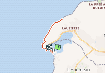
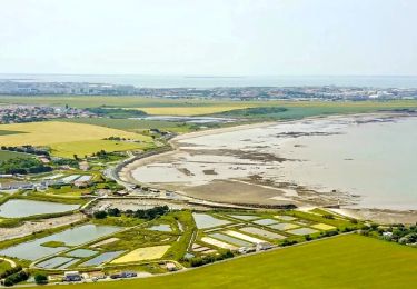
Tour Wandern von 5,5 km verfügbar auf Neu-Aquitanien, Charente-Maritime, L'Houmeau. Diese Tour wird von jpipacific vorgeschlagen.
Beschreibung
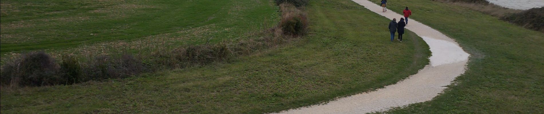
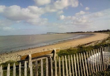
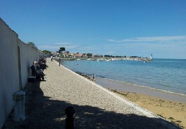
Balade en bord de mer organisée par Lulu.
Pas de difficulté. Vu sur l'ile de Ré et le pont.
Beaucoup de vent et un peu de pluie. Vivifiant !
Ort
Land:
France
Region :
Neu-Aquitanien
Abteilung/Provinz :
Charente-Maritime
Kommune :
L'Houmeau
Standort:
Unknown
Gehen Sie:(Dec)
Gehen Sie:(UTM)
638909 ; 5117857 (30T) N.
Kommentare
Touren in der Umgebung
![Tour Wandern Rivedoux-Plage - Sentier du littoral - Rivedoux-Plage - Photo](https://media.geolcdn.com/t/375/260/ext.jpg?maxdim=2&url=https%3A%2F%2Fservices.sitytrail.com%2FGeolivesWS%2FDownloadMedia.ashx%3FTrailID%3D191591%26Media%3D15221_6.jpg)
![Wandern Wandern](https://static1.geolcdn.com/sitytour/trail-icons/101.png)
Sentier du littoral - Rivedoux-Plage
Wandern
Medium
(1)
Rivedoux-Plage,
Neu-Aquitanien,
Charente-Maritime,
France
![](/images/other/stat-length.png)
10,8 km | 11,6 km-effort
2h 30min
![](https://static1.geolcdn.com/siteimages/upload/files/16400158638029165_repeat_loop_refresh_sync_direction_icon.png)
Ja
![Tour Wandern Rivedoux-Plage - Les Gros Peux - Rivedoux - Photo](https://media.geolcdn.com/t/375/260/ext.jpg?maxdim=2&url=https%3A%2F%2Fservices.sitytrail.com%2FGeolivesWS%2FDownloadMedia.ashx%3FTrailID%3D191590%26Media%3D15220_6.jpg)
![Wandern Wandern](https://static1.geolcdn.com/sitytour/trail-icons/101.png)
Les Gros Peux - Rivedoux
Wandern
Einfach
(5)
Rivedoux-Plage,
Neu-Aquitanien,
Charente-Maritime,
France
![](/images/other/stat-length.png)
6,4 km | 6,8 km-effort
1h 30min
![](https://static1.geolcdn.com/siteimages/upload/files/16400158638029165_repeat_loop_refresh_sync_direction_icon.png)
Ja
![Tour Fahrrad La Rochelle - la rochelle - Photo](https://media.geolcdn.com/t/375/260/ext.jpg?maxdim=2&url=https%3A%2F%2Fstatic1.geolcdn.com%2Fsiteimages%2Fupload%2Ffiles%2F1524743154velo.jpg)
![Fahrrad Fahrrad](https://static1.geolcdn.com/sitytour/trail-icons/200.png)
la rochelle
Fahrrad
Sehr leicht
(1)
La Rochelle,
Neu-Aquitanien,
Charente-Maritime,
France
![](/images/other/stat-length.png)
16,2 km | 17,5 km-effort
2h 17min
![](https://static1.geolcdn.com/siteimages/upload/files/16400158638029165_repeat_loop_refresh_sync_direction_icon.png)
Ja
![Tour Zu Fuß Rivedoux-Plage - Sentier du littoral - Photo](https://media.geolcdn.com/t/375/260/f34a5b01-8068-4aba-b707-54b730f52756.jpeg&format=jpg&maxdim=2)
![Zu Fuß Zu Fuß](https://static1.geolcdn.com/sitytour/trail-icons/100.png)
Sentier du littoral
Zu Fuß
Einfach
Rivedoux-Plage,
Neu-Aquitanien,
Charente-Maritime,
France
![](/images/other/stat-length.png)
10,6 km | 11,5 km-effort
2h 36min
![](https://static1.geolcdn.com/siteimages/upload/files/16400158638029165_repeat_loop_refresh_sync_direction_icon.png)
Nein
![Tour Wandern Rivedoux-Plage - Ile de Ré-La Flotte Rivedoux - Photo](https://media.geolcdn.com/t/375/260/ext.jpg?maxdim=2&url=https%3A%2F%2Fservices.sitytrail.com%2FGeolivesWS%2FDownloadMedia.ashx%3FTrailID%3D310151%26Media%3Dfix__20140607134515.jpg)
![Wandern Wandern](https://static1.geolcdn.com/sitytour/trail-icons/101.png)
Ile de Ré-La Flotte Rivedoux
Wandern
Einfach
Rivedoux-Plage,
Neu-Aquitanien,
Charente-Maritime,
France
![](/images/other/stat-length.png)
21 km | 23 km-effort
4h 24min
![](https://static1.geolcdn.com/siteimages/upload/files/16400158638029165_repeat_loop_refresh_sync_direction_icon.png)
Nein
![Tour Wandern Lagord - Nieul_Terre_Mer - Photo](https://media.geolcdn.com/t/375/260/9d212f40-6824-464e-8d1e-e93e2b9b5c5e.jpg&format=jpg&maxdim=2)
![Wandern Wandern](https://static1.geolcdn.com/sitytour/trail-icons/101.png)
Nieul_Terre_Mer
Wandern
Medium
Lagord,
Neu-Aquitanien,
Charente-Maritime,
France
![](/images/other/stat-length.png)
15,5 km | 16,6 km-effort
4h 45min
![](https://static1.geolcdn.com/siteimages/upload/files/16400158638029165_repeat_loop_refresh_sync_direction_icon.png)
Ja
![Tour Wandern La Rochelle - 21-09-2024 Boucle la Rochelle (journée patrimoine) - Photo](https://media.geolcdn.com/t/375/260/87e3f1cc-f691-452b-b046-b2fa4978e87f.jpg&format=jpg&maxdim=2)
![Wandern Wandern](https://static1.geolcdn.com/sitytour/trail-icons/101.png)
21-09-2024 Boucle la Rochelle (journée patrimoine)
Wandern
Medium
La Rochelle,
Neu-Aquitanien,
Charente-Maritime,
France
![](/images/other/stat-length.png)
7,5 km | 8,1 km-effort
1h 44min
![](https://static1.geolcdn.com/siteimages/upload/files/16400158638029165_repeat_loop_refresh_sync_direction_icon.png)
Ja
![Tour Wandern La Rochelle - la Rochelle - Photo](https://media.geolcdn.com/t/375/260/bee0954c-7523-4cce-8e2f-85ad76c4e573.jpg&format=jpg&maxdim=2)
![Wandern Wandern](https://static1.geolcdn.com/sitytour/trail-icons/101.png)
la Rochelle
Wandern
Sehr leicht
La Rochelle,
Neu-Aquitanien,
Charente-Maritime,
France
![](/images/other/stat-length.png)
17,8 km | 19,4 km-effort
4h 30min
![](https://static1.geolcdn.com/siteimages/upload/files/16400158638029165_repeat_loop_refresh_sync_direction_icon.png)
Ja
![Tour Wandern L'Houmeau - NIEUL - Photo](https://media.geolcdn.com/t/375/260/ext.jpg?maxdim=2&url=https%3A%2F%2Fstatic1.geolcdn.com%2Fsiteimages%2Fupload%2Ffiles%2F1553511878bg_sport_marche.png)
![Wandern Wandern](https://static1.geolcdn.com/sitytour/trail-icons/101.png)
NIEUL
Wandern
Medium
L'Houmeau,
Neu-Aquitanien,
Charente-Maritime,
France
![](/images/other/stat-length.png)
8 km | 8,5 km-effort
1h 56min
![](https://static1.geolcdn.com/siteimages/upload/files/16400158638029165_repeat_loop_refresh_sync_direction_icon.png)
Ja