![](/images/other/stat-length.png)
![Tour Wandern Château-l'Évêque - CHATEAU-LEVEQUE - Boucle de Preyssac courte - Photo](https://media.geolcdn.com/t/1900/400/ext.pjpeg?maxdim=2&url=https%3A%2F%2Fstatic1.geolcdn.com%2Fsiteimages%2Fupload%2Ffiles%2F1553511878bg_sport_marche.png)
CHATEAU-LEVEQUE - Boucle de Preyssac courte
DDESLAN
Benutzer
![Länge](/images/other/stat-length.png)
Länge
11,3 km
![Maximale Höhe](https://static1.geolcdn.com/siteimages/upload/files/1508320355ic_sort_altitude_max_24dp.png)
Maximale Höhe
214 m
![Positive Höhendifferenz](https://static1.geolcdn.com/siteimages/upload/files/1508320355ic_sort_den_pos_24dp.png)
Positive Höhendifferenz
302 m
![Km-Effort](/images/other/stat-length.png)
Km-Effort
15,4 km
![Min. Höhe](https://static1.geolcdn.com/siteimages/upload/files/1508320355ic_sort_altitude_min_24dp.png)
Min. Höhe
103 m
![Negative Höhendifferenz](https://static1.geolcdn.com/siteimages/upload/files/1508320355ic_sort_den_neg_24dp.png)
Negative Höhendifferenz
302 m
![Boucle](https://static1.geolcdn.com/siteimages/upload/files/16400158638029165_repeat_loop_refresh_sync_direction_icon.png)
Boucle
Ja
Erstellungsdatum :
2023-10-25 09:45:06.785
Letzte Änderung :
2023-10-25 09:51:29.433
![Wandern](https://static1.geolcdn.com/sitytour/trail-icons/101.png)
3h29
Schwierigkeit : Schwierig
![Scannen Sie diesen QR-Code, um die Tour in der SityTrail-Anwendung zu öffnen](https://capi.geolives.com/qq0zvz2zws4bq2lad0pu/sitytour/trails/3849956/qr.png?size=200)
Kostenlosegpshiking-Anwendung
Über SityTrail
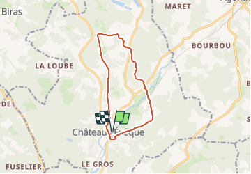
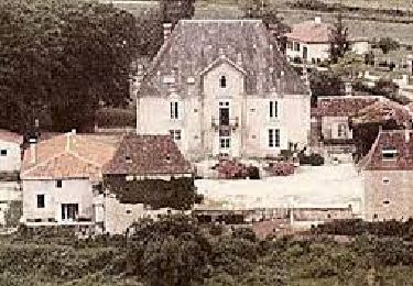
Tour Wandern von 11,3 km verfügbar auf Neu-Aquitanien, Dordogne, Château-l'Évêque. Diese Tour wird von DDESLAN vorgeschlagen.
Beschreibung
Départ depuis le PK de la gare de Château-Lévêque
Mise à jour le 25-10-2023 suite à découverte chemin public "sauvagement privatisé"
Ort
Land:
France
Region :
Neu-Aquitanien
Abteilung/Provinz :
Dordogne
Kommune :
Château-l'Évêque
Standort:
Unknown
Gehen Sie:(Dec)
Gehen Sie:(UTM)
318569 ; 5012769 (31T) N.
Kommentare
Touren in der Umgebung
![Tour Wandern Champcevinel - champcevinel - Photo](https://media.geolcdn.com/t/375/260/ee6533d5-1951-437a-84ea-112f8c5e298d.jpg&format=jpg&maxdim=2)
![Wandern Wandern](https://static1.geolcdn.com/sitytour/trail-icons/101.png)
champcevinel
Wandern
Schwierig
Champcevinel,
Neu-Aquitanien,
Dordogne,
France
![](/images/other/stat-length.png)
9,7 km | 12,3 km-effort
2h 48min
![](https://static1.geolcdn.com/siteimages/upload/files/16400158638029165_repeat_loop_refresh_sync_direction_icon.png)
Ja
![Tour Wandern Château-l'Évêque - Preyssac - Photo](https://media.geolcdn.com/t/375/260/88e8b94c-04c3-4391-bcaf-c73b6b33a5ce.jpg&format=jpg&maxdim=2)
![Wandern Wandern](https://static1.geolcdn.com/sitytour/trail-icons/101.png)
Preyssac
Wandern
Schwierig
Château-l'Évêque,
Neu-Aquitanien,
Dordogne,
France
![](/images/other/stat-length.png)
11 km | 14,5 km-effort
3h 17min
![](https://static1.geolcdn.com/siteimages/upload/files/16400158638029165_repeat_loop_refresh_sync_direction_icon.png)
Ja
![Tour Wandern Chancelade - Circuit de l'Abbaye de Chancelade - Photo](https://media.geolcdn.com/t/375/260/16bcd257-155c-4b42-a479-9684c98ab4d4.jpg&format=jpg&maxdim=2)
![Wandern Wandern](https://static1.geolcdn.com/sitytour/trail-icons/101.png)
Circuit de l'Abbaye de Chancelade
Wandern
Schwierig
Chancelade,
Neu-Aquitanien,
Dordogne,
France
![](/images/other/stat-length.png)
12,8 km | 18,3 km-effort
4h 9min
![](https://static1.geolcdn.com/siteimages/upload/files/16400158638029165_repeat_loop_refresh_sync_direction_icon.png)
Ja
![Tour Wandern Château-l'Évêque - Boucle du bois de Lavergne - Photo](https://media.geolcdn.com/t/375/260/6537e41d-5ba3-471f-b695-a5c123990690.jpg&format=jpg&maxdim=2)
![Wandern Wandern](https://static1.geolcdn.com/sitytour/trail-icons/101.png)
Boucle du bois de Lavergne
Wandern
Schwierig
Château-l'Évêque,
Neu-Aquitanien,
Dordogne,
France
![](/images/other/stat-length.png)
14,1 km | 17,8 km-effort
4h 2min
![](https://static1.geolcdn.com/siteimages/upload/files/16400158638029165_repeat_loop_refresh_sync_direction_icon.png)
Ja
![Tour Wandern Chancelade - Boucle des Andrivaux - Photo](https://media.geolcdn.com/t/375/260/3a7f865a-dc4d-41a4-a258-9294003c8232.jpg&format=jpg&maxdim=2)
![Wandern Wandern](https://static1.geolcdn.com/sitytour/trail-icons/101.png)
Boucle des Andrivaux
Wandern
Sehr schwierig
Chancelade,
Neu-Aquitanien,
Dordogne,
France
![](/images/other/stat-length.png)
14,8 km | 19,3 km-effort
4h 23min
![](https://static1.geolcdn.com/siteimages/upload/files/16400158638029165_repeat_loop_refresh_sync_direction_icon.png)
Ja
![Tour Wandern Chancelade - Boucle de la Terrassonnie - Photo](https://media.geolcdn.com/t/375/260/ext.jpg?maxdim=2&url=https%3A%2F%2Fservices.sitytrail.com%2FGeolivesWS%2FDownloadMedia.ashx%3FTrailID%3D1093073%26Media%3Dfix__20190106115620.jpg)
![Wandern Wandern](https://static1.geolcdn.com/sitytour/trail-icons/101.png)
Boucle de la Terrassonnie
Wandern
Einfach
Chancelade,
Neu-Aquitanien,
Dordogne,
France
![](/images/other/stat-length.png)
11,2 km | 14,7 km-effort
3h 37min
![](https://static1.geolcdn.com/siteimages/upload/files/16400158638029165_repeat_loop_refresh_sync_direction_icon.png)
Ja
![Tour Wandern Château-l'Évêque - boucle Chateau l'Eveque - Photo](https://media.geolcdn.com/t/375/260/ext.jpg?maxdim=2&url=https%3A%2F%2Fstatic1.geolcdn.com%2Fsiteimages%2Fupload%2Ffiles%2F1553511878bg_sport_marche.png)
![Wandern Wandern](https://static1.geolcdn.com/sitytour/trail-icons/101.png)
boucle Chateau l'Eveque
Wandern
Medium
Château-l'Évêque,
Neu-Aquitanien,
Dordogne,
France
![](/images/other/stat-length.png)
13,7 km | 18,3 km-effort
3h 28min
![](https://static1.geolcdn.com/siteimages/upload/files/16400158638029165_repeat_loop_refresh_sync_direction_icon.png)
Ja
![Tour Wandern Champcevinel - Boucle Champcevinel par lac Lacroix - Photo](https://media.geolcdn.com/t/375/260/ext.jpg?maxdim=2&url=https%3A%2F%2Fstatic1.geolcdn.com%2Fsiteimages%2Fupload%2Ffiles%2F1553511878bg_sport_marche.png)
![Wandern Wandern](https://static1.geolcdn.com/sitytour/trail-icons/101.png)
Boucle Champcevinel par lac Lacroix
Wandern
Einfach
Champcevinel,
Neu-Aquitanien,
Dordogne,
France
![](/images/other/stat-length.png)
12,1 km | 15,4 km-effort
2h 45min
![](https://static1.geolcdn.com/siteimages/upload/files/16400158638029165_repeat_loop_refresh_sync_direction_icon.png)
Ja
![Tour Wandern Chancelade - Chancelade - Photo](https://media.geolcdn.com/t/375/260/f516afca-a53a-45cf-8602-c47268c2e555.jpg&format=jpg&maxdim=2)
![Wandern Wandern](https://static1.geolcdn.com/sitytour/trail-icons/101.png)
Chancelade
Wandern
Schwierig
Chancelade,
Neu-Aquitanien,
Dordogne,
France
![](/images/other/stat-length.png)
13,7 km | 18,4 km-effort
4h 11min
![](https://static1.geolcdn.com/siteimages/upload/files/16400158638029165_repeat_loop_refresh_sync_direction_icon.png)
Ja