![](/images/other/stat-length.png)
![Tour Wandern Volonne - Tour du lac de Volonne - Photo](https://media.geolcdn.com/t/1900/400/e677eb7b-cbbf-4a6d-a9a8-10ec692c0aed.jpg&format=pjpeg&maxdim=2)
Tour du lac de Volonne
babouille
Benutzer
![Länge](/images/other/stat-length.png)
![Maximale Höhe](https://static1.geolcdn.com/siteimages/upload/files/1508320355ic_sort_altitude_max_24dp.png)
![Positive Höhendifferenz](https://static1.geolcdn.com/siteimages/upload/files/1508320355ic_sort_den_pos_24dp.png)
![Km-Effort](/images/other/stat-length.png)
![Min. Höhe](https://static1.geolcdn.com/siteimages/upload/files/1508320355ic_sort_altitude_min_24dp.png)
![Negative Höhendifferenz](https://static1.geolcdn.com/siteimages/upload/files/1508320355ic_sort_den_neg_24dp.png)
![Boucle](https://static1.geolcdn.com/siteimages/upload/files/16400158638029165_repeat_loop_refresh_sync_direction_icon.png)
![Wandern](https://static1.geolcdn.com/sitytour/trail-icons/101.png)
1h54
Schwierigkeit : Medium
![Scannen Sie diesen QR-Code, um die Tour in der SityTrail-Anwendung zu öffnen](https://capi.geolives.com/qq0zvz2zws4bq2lad0pu/sitytour/trails/3848483/qr.png?size=200)
Kostenlosegpshiking-Anwendung
Über SityTrail
Tour Wandern von 7,5 km verfügbar auf Provence-Alpes-Côte d'Azur, Alpes-de-Haute-Provence, Volonne. Diese Tour wird von babouille vorgeschlagen.
Beschreibung
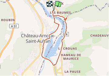
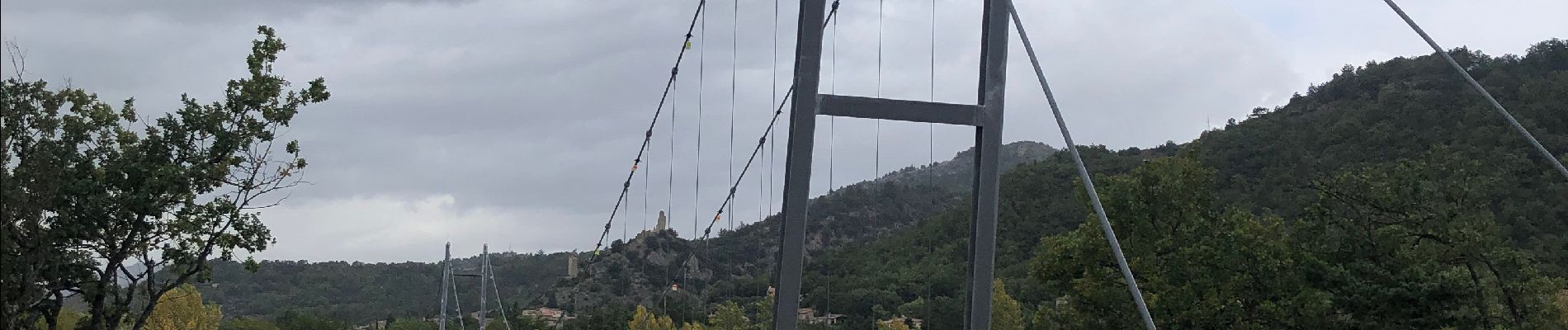
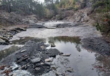
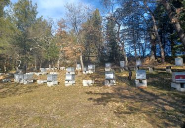
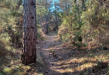
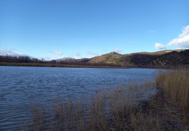
Se garer au Parking du Camping de L'Escale , rejoindre la passerelle au bord du lac sans la prendre , suivre le sentier à gauche ( sud ) qui surplombe une zone humide . le sentier suit un moment la route sans la croiser . le balisage par des bornes (voir la photo ) est précis . Aller jusqu'au pont qui enjambe la Durance sur le barrage (photo) Poursuivre vers le nord le sentier bien balisé jusqu'à la passerelle qui nous ramène au parking.
Ort
Kommentare
Touren in der Umgebung
![Tour Wandern Aubignosc - AUBIGNOSC. Vieil Chateau Neuf , canyons o l m s - Photo](https://media.geolcdn.com/t/375/260/65ebcf05-a4c8-4543-8e63-050694c809e9.jpg&format=jpg&maxdim=2)
![Wandern Wandern](https://static1.geolcdn.com/sitytour/trail-icons/101.png)
Wandern
![](/images/other/stat-length.png)
![](https://static1.geolcdn.com/siteimages/upload/files/16400158638029165_repeat_loop_refresh_sync_direction_icon.png)
![Tour Wandern Aubignosc - AUBIGNOSC . LE PETIT COLORADO . O L S - Photo](https://media.geolcdn.com/t/375/260/9769e6c8-7278-4da5-a931-29d787d20283.jpg&format=jpg&maxdim=2)
![Wandern Wandern](https://static1.geolcdn.com/sitytour/trail-icons/101.png)
Wandern
![](/images/other/stat-length.png)
![](https://static1.geolcdn.com/siteimages/upload/files/16400158638029165_repeat_loop_refresh_sync_direction_icon.png)
![Tour Wandern Château-Arnoux-Saint-Auban - SAINT AUBAN . SENTIER DE DÉCOUVERTE DE L AÉRODROME O L - Photo](https://media.geolcdn.com/t/375/260/5308a4ad-7d11-40e8-b20c-9444363024fd.jpg&format=jpg&maxdim=2)
![Wandern Wandern](https://static1.geolcdn.com/sitytour/trail-icons/101.png)
Wandern
![](/images/other/stat-length.png)
![](https://static1.geolcdn.com/siteimages/upload/files/16400158638029165_repeat_loop_refresh_sync_direction_icon.png)
![Tour Wandern Château-Arnoux-Saint-Auban - CHATEAU ARNOUX. S Jean , chemin des Bruyères, les Grandes Côtes o l s - Photo](https://media.geolcdn.com/t/375/260/053ba967-5713-4669-b325-8e9d67549d6c.jpg&format=jpg&maxdim=2)
![Wandern Wandern](https://static1.geolcdn.com/sitytour/trail-icons/101.png)
Wandern
![](/images/other/stat-length.png)
![](https://static1.geolcdn.com/siteimages/upload/files/16400158638029165_repeat_loop_refresh_sync_direction_icon.png)
![Tour Wandern Peipin - PEIPIN . aubignosc. Le vieux village Château Neuf Val Saint Donnât par GR7 o 53D - Photo](https://media.geolcdn.com/t/375/260/ext.jpg?maxdim=2&url=https%3A%2F%2Fstatic1.geolcdn.com%2Fsiteimages%2Fupload%2Ffiles%2F1553511878bg_sport_marche.png)
![Wandern Wandern](https://static1.geolcdn.com/sitytour/trail-icons/101.png)
Wandern
![](/images/other/stat-length.png)
![](https://static1.geolcdn.com/siteimages/upload/files/16400158638029165_repeat_loop_refresh_sync_direction_icon.png)
![Tour Laufen Volonne - les 2 sommets sr Jean et tigne - Photo](https://media.geolcdn.com/t/375/260/ext.jpg?maxdim=2&url=https%3A%2F%2Fservices.sitytrail.com%2FGeolivesWS%2FDownloadMedia.ashx%3FTrailID%3D506279%26Media%3Dfix__20151226163303.jpg)
![Laufen Laufen](https://static1.geolcdn.com/sitytour/trail-icons/103.png)
Laufen
![](/images/other/stat-length.png)
![](https://static1.geolcdn.com/siteimages/upload/files/16400158638029165_repeat_loop_refresh_sync_direction_icon.png)
![Tour Wandern Château-Arnoux-Saint-Auban - CHATEAU A. LES AMARINES. LES CRETES. FONT DU COGNET O L - Photo](https://media.geolcdn.com/t/375/260/677d9e47-ae20-4f87-96e2-8d37b2abeef1.jpg&format=jpg&maxdim=2)
![Wandern Wandern](https://static1.geolcdn.com/sitytour/trail-icons/101.png)
Wandern
![](/images/other/stat-length.png)
![](https://static1.geolcdn.com/siteimages/upload/files/16400158638029165_repeat_loop_refresh_sync_direction_icon.png)
![Tour Wandern Château-Arnoux-Saint-Auban - CHATEAU ARNOUX. CRETE DES AMARINES . CIRCUIT DES BRUYERES O L. S - Photo](https://media.geolcdn.com/t/375/260/24591c0c-5928-43be-9e78-124cab9c84af.jpg&format=jpg&maxdim=2)
![Wandern Wandern](https://static1.geolcdn.com/sitytour/trail-icons/101.png)
Wandern
![](/images/other/stat-length.png)
![](https://static1.geolcdn.com/siteimages/upload/files/16400158638029165_repeat_loop_refresh_sync_direction_icon.png)
![Tour Wandern L'Escale - Les Balcons de la Durance 11.2.24 - Photo](https://media.geolcdn.com/t/375/260/0c181ea8-d592-4fc1-a24c-1c5ed7f6ced7.jpg&format=jpg&maxdim=2)
![Wandern Wandern](https://static1.geolcdn.com/sitytour/trail-icons/101.png)
Wandern
![](/images/other/stat-length.png)
![](https://static1.geolcdn.com/siteimages/upload/files/16400158638029165_repeat_loop_refresh_sync_direction_icon.png)