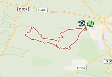
![](/images/other/stat-length.png)
![Tour Wandern Fontainebleau - Fontainebleau - Sentier des carriers - Photo](https://media.geolcdn.com/t/1900/400/7a9ec883-9e0b-4aab-bb4b-d6c444204940.jpg&format=pjpeg&maxdim=2)
Fontainebleau - Sentier des carriers
guydu41
Benutzer
![Länge](/images/other/stat-length.png)
![Maximale Höhe](https://static1.geolcdn.com/siteimages/upload/files/1508320355ic_sort_altitude_max_24dp.png)
![Positive Höhendifferenz](https://static1.geolcdn.com/siteimages/upload/files/1508320355ic_sort_den_pos_24dp.png)
![Km-Effort](/images/other/stat-length.png)
![Min. Höhe](https://static1.geolcdn.com/siteimages/upload/files/1508320355ic_sort_altitude_min_24dp.png)
![Negative Höhendifferenz](https://static1.geolcdn.com/siteimages/upload/files/1508320355ic_sort_den_neg_24dp.png)
![Boucle](https://static1.geolcdn.com/siteimages/upload/files/16400158638029165_repeat_loop_refresh_sync_direction_icon.png)
![Wandern](https://static1.geolcdn.com/sitytour/trail-icons/101.png)
2h04
Schwierigkeit : Medium
![Scannen Sie diesen QR-Code, um die Tour in der SityTrail-Anwendung zu öffnen](https://capi.geolives.com/qq0zvz2zws4bq2lad0pu/sitytour/trails/3846298/qr.png?size=200)
Kostenlosegpshiking-Anwendung
Über SityTrail
Tour Wandern von 7,5 km verfügbar auf Île-de-France, Seine-et-Marne, Fontainebleau. Diese Tour wird von guydu41 vorgeschlagen.
Beschreibung
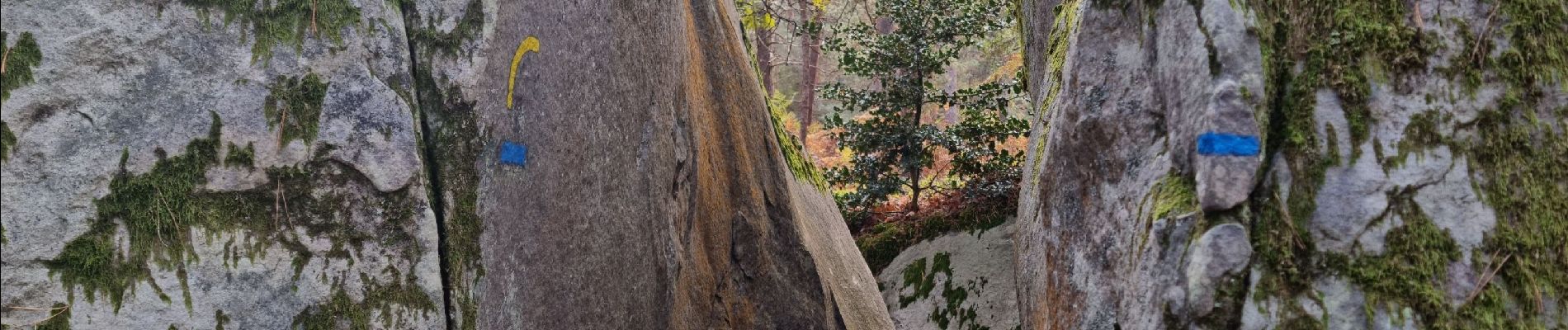
Très beau circuit balisé jaune souvent commun avec les circuits Denecourt balisés bleus. Il chemine principalement sur des sentiers étroits, tortueux, qui montent et descendent dans les chaos rocheux de la Forêt de Fontainebleau.
Découverte d'abris de carriers, passage dans de nombreuses anfractuosités entre rochers, dans plusieurs tunnels, etc.
De nombreux points de vue permettent d'admirer de magnifiques paysages.
Ort
Kommentare
Touren in der Umgebung
![Tour Wandern Fontainebleau - La Mare aux Fées 18km - Forêt de Fontainebleau - Photo](https://media.geolcdn.com/t/375/260/ext.jpg?maxdim=2&url=https%3A%2F%2Fstatic1.geolcdn.com%2Fsiteimages%2Fupload%2Ffiles%2F1553511878bg_sport_marche.png)
![Wandern Wandern](https://static1.geolcdn.com/sitytour/trail-icons/101.png)
Wandern
![](/images/other/stat-length.png)
![](https://static1.geolcdn.com/siteimages/upload/files/16400158638029165_repeat_loop_refresh_sync_direction_icon.png)
![Tour Zu Fuß Fontainebleau - Boucle 28 km en forêt de Fontainebleau - Photo](https://media.geolcdn.com/t/375/260/21e3a864-d768-407e-8af1-222ee36d7889.jpg&format=jpg&maxdim=2)
![Zu Fuß Zu Fuß](https://static1.geolcdn.com/sitytour/trail-icons/100.png)
Zu Fuß
![](/images/other/stat-length.png)
![](https://static1.geolcdn.com/siteimages/upload/files/16400158638029165_repeat_loop_refresh_sync_direction_icon.png)
![Tour Wandern Fontainebleau - 3pi-150428 - DésertApremont-Jupiter - Photo](https://media.geolcdn.com/t/375/260/ext.jpg?maxdim=2&url=https%3A%2F%2Fservices.sitytrail.com%2FGeolivesWS%2FDownloadMedia.ashx%3FTrailID%3D414037%26Media%3D22942274-9308-46bb-bc6d-06c82c3e8751.jpg)
![Wandern Wandern](https://static1.geolcdn.com/sitytour/trail-icons/101.png)
Wandern
![](/images/other/stat-length.png)
![](https://static1.geolcdn.com/siteimages/upload/files/16400158638029165_repeat_loop_refresh_sync_direction_icon.png)
![Tour Wandern Fontainebleau - Rocher Fourceau-Petit Mont Chauvet SR210523Ve?? fmg - Photo](https://media.geolcdn.com/t/375/260/cabc9437-0e04-4fa0-9f5b-0c9f73ac9000.jpg&format=jpg&maxdim=2)
![Wandern Wandern](https://static1.geolcdn.com/sitytour/trail-icons/101.png)
Wandern
![](/images/other/stat-length.png)
![](https://static1.geolcdn.com/siteimages/upload/files/16400158638029165_repeat_loop_refresh_sync_direction_icon.png)
![Tour Wandern Fontainebleau - Rando mares aux fees Gilles18 km - Photo](https://media.geolcdn.com/t/375/260/1a2c21e9-241f-4517-a09c-d9710ae3d7d2.jpg&format=jpg&maxdim=2)
![Wandern Wandern](https://static1.geolcdn.com/sitytour/trail-icons/101.png)
Wandern
![](/images/other/stat-length.png)
![](https://static1.geolcdn.com/siteimages/upload/files/16400158638029165_repeat_loop_refresh_sync_direction_icon.png)
![Tour Wandern Fontainebleau - 131204-GLM - CxToulouse-StLouis - Photo](https://media.geolcdn.com/t/375/260/ext.jpg?maxdim=2&url=https%3A%2F%2Fservices.sitytrail.com%2FGeolivesWS%2FDownloadMedia.ashx%3FTrailID%3D235773%26Media%3Df4996202-b0e3-463d-bbc3-f9ae550a1c06.jpg)
![Wandern Wandern](https://static1.geolcdn.com/sitytour/trail-icons/101.png)
Wandern
![](/images/other/stat-length.png)
![](https://static1.geolcdn.com/siteimages/upload/files/16400158638029165_repeat_loop_refresh_sync_direction_icon.png)
![Tour Wandern Fontainebleau - Boucle du Château de Fontainebleau à Thomery 21 km - Photo](https://media.geolcdn.com/t/375/260/22a500a3-91bf-4087-9234-7c012b4b260f.jpg&format=jpg&maxdim=2)
![Wandern Wandern](https://static1.geolcdn.com/sitytour/trail-icons/101.png)
Wandern
![](/images/other/stat-length.png)
![](https://static1.geolcdn.com/siteimages/upload/files/16400158638029165_repeat_loop_refresh_sync_direction_icon.png)
![Tour Wandern Fontainebleau - Boucle Barbizon - Arbonne 26 km - Photo](https://media.geolcdn.com/t/375/260/d3a133ff-ea77-47a6-826a-54bbe45391c4.jpg&format=jpg&maxdim=2)
![Wandern Wandern](https://static1.geolcdn.com/sitytour/trail-icons/101.png)
Wandern
![](/images/other/stat-length.png)
![](https://static1.geolcdn.com/siteimages/upload/files/16400158638029165_repeat_loop_refresh_sync_direction_icon.png)
![Tour Wandern Fontainebleau - Sentier Denecourt N°9 Rocher des Demoiselles - Photo](https://media.geolcdn.com/t/375/260/ext.jpg?maxdim=2&url=https%3A%2F%2Fstatic1.geolcdn.com%2Fsiteimages%2Fupload%2Ffiles%2F1553511878bg_sport_marche.png)
![Wandern Wandern](https://static1.geolcdn.com/sitytour/trail-icons/101.png)
Wandern
![](/images/other/stat-length.png)
![](https://static1.geolcdn.com/siteimages/upload/files/16400158638029165_repeat_loop_refresh_sync_direction_icon.png)