![](/images/other/stat-length.png)
![Tour Wandern Trilport - La forêt de Montceaux - Photo](https://media.geolcdn.com/t/1900/400/ext.pjpeg?maxdim=2&url=https%3A%2F%2Fstatic1.geolcdn.com%2Fsiteimages%2Fupload%2Ffiles%2F1553511878bg_sport_marche.png)
La forêt de Montceaux
Randos du mercredi
Le mercredi c'est rando
![Länge](/images/other/stat-length.png)
Länge
18,5 km
![Maximale Höhe](https://static1.geolcdn.com/siteimages/upload/files/1508320355ic_sort_altitude_max_24dp.png)
Maximale Höhe
163 m
![Positive Höhendifferenz](https://static1.geolcdn.com/siteimages/upload/files/1508320355ic_sort_den_pos_24dp.png)
Positive Höhendifferenz
238 m
![Km-Effort](/images/other/stat-length.png)
Km-Effort
22 km
![Min. Höhe](https://static1.geolcdn.com/siteimages/upload/files/1508320355ic_sort_altitude_min_24dp.png)
Min. Höhe
46 m
![Negative Höhendifferenz](https://static1.geolcdn.com/siteimages/upload/files/1508320355ic_sort_den_neg_24dp.png)
Negative Höhendifferenz
238 m
![Boucle](https://static1.geolcdn.com/siteimages/upload/files/16400158638029165_repeat_loop_refresh_sync_direction_icon.png)
Boucle
Ja
Erstellungsdatum :
2023-10-08 13:27:51.371
Letzte Änderung :
2023-10-08 13:29:16.594
![Wandern](https://static1.geolcdn.com/sitytour/trail-icons/101.png)
4h55
Schwierigkeit : Sehr schwierig
![Scannen Sie diesen QR-Code, um die Tour in der SityTrail-Anwendung zu öffnen](https://capi.geolives.com/qq0zvz2zws4bq2lad0pu/sitytour/trails/3833196/qr.png?size=200)
Kostenlosegpshiking-Anwendung
Über SityTrail
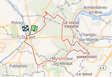
Tour Wandern von 18,5 km verfügbar auf Île-de-France, Seine-et-Marne, Trilport. Diese Tour wird von Randos du mercredi vorgeschlagen.
Beschreibung
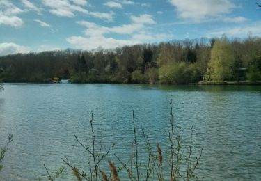
Un parcours dans un large méandre de la Marne, qui allie forêt, champs et territoires urbains, à apprécier en toute période.
Ort
Land:
France
Region :
Île-de-France
Abteilung/Provinz :
Seine-et-Marne
Kommune :
Trilport
Standort:
Unknown
Gehen Sie:(Dec)
Gehen Sie:(UTM)
496279 ; 5423014 (31U) N.
Kommentare
Touren in der Umgebung
![Tour Mountainbike Nanteuil-lès-Meaux - tite boucle Nanteuil par l'eau - Photo](https://media.geolcdn.com/t/375/260/ext.jpg?maxdim=2&url=https%3A%2F%2Fservices.sitytrail.com%2FGeolivesWS%2FDownloadMedia.ashx%3FTrailID%3D263705%26Media%3Dfix__20140406122359.jpg)
![Mountainbike Mountainbike](https://static1.geolcdn.com/sitytour/trail-icons/202.png)
tite boucle Nanteuil par l'eau
Mountainbike
Einfach
(1)
Nanteuil-lès-Meaux,
Île-de-France,
Seine-et-Marne,
France
![](/images/other/stat-length.png)
23 km | 26 km-effort
1h 48min
![](https://static1.geolcdn.com/siteimages/upload/files/16400158638029165_repeat_loop_refresh_sync_direction_icon.png)
Ja
![Tour Wandern Meaux - SM_MEAUX_LePâtis_8km. - Photo](https://media.geolcdn.com/t/375/260/59d59af8-64ac-4cd9-8525-6af37371405a.jpg&format=jpg&maxdim=2)
![Wandern Wandern](https://static1.geolcdn.com/sitytour/trail-icons/101.png)
SM_MEAUX_LePâtis_8km.
Wandern
Einfach
(3)
Meaux,
Île-de-France,
Seine-et-Marne,
France
![](/images/other/stat-length.png)
7,9 km | 8,4 km-effort
1h 54min
![](https://static1.geolcdn.com/siteimages/upload/files/16400158638029165_repeat_loop_refresh_sync_direction_icon.png)
Ja
![Tour Wandern Trilport - SityTrail - GR15-07 Trilport à - Photo](https://media.geolcdn.com/t/375/260/ext.jpg?maxdim=2&url=https%3A%2F%2Fstatic1.geolcdn.com%2Fsiteimages%2Fupload%2Ffiles%2F1553511878bg_sport_marche.png)
![Wandern Wandern](https://static1.geolcdn.com/sitytour/trail-icons/101.png)
SityTrail - GR15-07 Trilport à
Wandern
Schwierig
(1)
Trilport,
Île-de-France,
Seine-et-Marne,
France
![](/images/other/stat-length.png)
10,6 km | 12,7 km-effort
2h 52min
![](https://static1.geolcdn.com/siteimages/upload/files/16400158638029165_repeat_loop_refresh_sync_direction_icon.png)
Nein
![Tour Wandern Meaux - Canal autour de Meaux - Photo](https://media.geolcdn.com/t/375/260/ext.jpg?maxdim=2&url=https%3A%2F%2Fstatic1.geolcdn.com%2Fsiteimages%2Fupload%2Ffiles%2F1553511878bg_sport_marche.png)
![Wandern Wandern](https://static1.geolcdn.com/sitytour/trail-icons/101.png)
Canal autour de Meaux
Wandern
Einfach
(1)
Meaux,
Île-de-France,
Seine-et-Marne,
France
![](/images/other/stat-length.png)
11,4 km | 12,3 km-effort
2h 51min
![](https://static1.geolcdn.com/siteimages/upload/files/16400158638029165_repeat_loop_refresh_sync_direction_icon.png)
Ja
![Tour Wandern Chambry - Chambry Grand Parcours - Photo](https://media.geolcdn.com/t/375/260/ext.jpg?maxdim=2&url=https%3A%2F%2Fstatic1.geolcdn.com%2Fsiteimages%2Fupload%2Ffiles%2F1553511878bg_sport_marche.png)
![Wandern Wandern](https://static1.geolcdn.com/sitytour/trail-icons/101.png)
Chambry Grand Parcours
Wandern
Einfach
(2)
Chambry,
Île-de-France,
Seine-et-Marne,
France
![](/images/other/stat-length.png)
18,3 km | 20 km-effort
4h 29min
![](https://static1.geolcdn.com/siteimages/upload/files/16400158638029165_repeat_loop_refresh_sync_direction_icon.png)
Ja
![Tour Wandern Germigny-l'Évêque - ballade en forêt de montceaux - Photo](https://media.geolcdn.com/t/375/260/ext.jpg?maxdim=2&url=https%3A%2F%2Fstatic1.geolcdn.com%2Fsiteimages%2Fupload%2Ffiles%2F1553511878bg_sport_marche.png)
![Wandern Wandern](https://static1.geolcdn.com/sitytour/trail-icons/101.png)
ballade en forêt de montceaux
Wandern
Sehr leicht
(1)
Germigny-l'Évêque,
Île-de-France,
Seine-et-Marne,
France
![](/images/other/stat-length.png)
5 km | 5,8 km-effort
1h 23min
![](https://static1.geolcdn.com/siteimages/upload/files/16400158638029165_repeat_loop_refresh_sync_direction_icon.png)
Ja
![Tour Laufen Meaux - Meaux Condorcet - Photo](https://media.geolcdn.com/t/375/260/ext.jpg?maxdim=2&url=https%3A%2F%2Fstatic1.geolcdn.com%2Fsiteimages%2Fupload%2Ffiles%2F1524743154running.jpg)
![Laufen Laufen](https://static1.geolcdn.com/sitytour/trail-icons/103.png)
Meaux Condorcet
Laufen
Sehr leicht
(2)
Meaux,
Île-de-France,
Seine-et-Marne,
France
![](/images/other/stat-length.png)
11,5 km | 12,5 km-effort
1h 0min
![](https://static1.geolcdn.com/siteimages/upload/files/16400158638029165_repeat_loop_refresh_sync_direction_icon.png)
Ja
![Tour Laufen Mareuil-lès-Meaux - Collège Nanteuil - Photo](https://media.geolcdn.com/t/375/260/ext.jpg?maxdim=2&url=https%3A%2F%2Fstatic1.geolcdn.com%2Fsiteimages%2Fupload%2Ffiles%2F1524743154running.jpg)
![Laufen Laufen](https://static1.geolcdn.com/sitytour/trail-icons/103.png)
Collège Nanteuil
Laufen
Sehr leicht
(1)
Mareuil-lès-Meaux,
Île-de-France,
Seine-et-Marne,
France
![](/images/other/stat-length.png)
10,3 km | 11,6 km-effort
1h 0min
![](https://static1.geolcdn.com/siteimages/upload/files/16400158638029165_repeat_loop_refresh_sync_direction_icon.png)
Ja
![Tour Wandern Meaux - Le Parc naturel du Pâtis - Photo](https://media.geolcdn.com/t/375/260/ext.jpg?maxdim=2&url=https%3A%2F%2Fstatic1.geolcdn.com%2Fsiteimages%2Fupload%2Ffiles%2F1553511878bg_sport_marche.png)
![Wandern Wandern](https://static1.geolcdn.com/sitytour/trail-icons/101.png)
Le Parc naturel du Pâtis
Wandern
Einfach
(1)
Meaux,
Île-de-France,
Seine-et-Marne,
France
![](/images/other/stat-length.png)
12,5 km | 13,4 km-effort
2h 58min
![](https://static1.geolcdn.com/siteimages/upload/files/16400158638029165_repeat_loop_refresh_sync_direction_icon.png)
Ja