![](/images/other/stat-length.png)
![Tour Wandern Le Perréon - La Haye des... Le Perréon - Photo](https://media.geolcdn.com/t/1900/400/ext.pjpeg?maxdim=2&url=https%3A%2F%2Fstatic1.geolcdn.com%2Fsiteimages%2Fupload%2Ffiles%2F1553511878bg_sport_marche.png)
La Haye des... Le Perréon
fernand1254
Benutzer
![Länge](/images/other/stat-length.png)
Länge
19,4 km
![Maximale Höhe](https://static1.geolcdn.com/siteimages/upload/files/1508320355ic_sort_altitude_max_24dp.png)
Maximale Höhe
789 m
![Positive Höhendifferenz](https://static1.geolcdn.com/siteimages/upload/files/1508320355ic_sort_den_pos_24dp.png)
Positive Höhendifferenz
538 m
![Km-Effort](/images/other/stat-length.png)
Km-Effort
28 km
![Min. Höhe](https://static1.geolcdn.com/siteimages/upload/files/1508320355ic_sort_altitude_min_24dp.png)
Min. Höhe
305 m
![Negative Höhendifferenz](https://static1.geolcdn.com/siteimages/upload/files/1508320355ic_sort_den_neg_24dp.png)
Negative Höhendifferenz
946 m
![Boucle](https://static1.geolcdn.com/siteimages/upload/files/16400158638029165_repeat_loop_refresh_sync_direction_icon.png)
Boucle
Nein
Erstellungsdatum :
2023-10-03 12:07:46.708
Letzte Änderung :
2023-10-04 12:21:07.698
![Wandern](https://static1.geolcdn.com/sitytour/trail-icons/101.png)
4h00
Schwierigkeit : Medium
![Scannen Sie diesen QR-Code, um die Tour in der SityTrail-Anwendung zu öffnen](https://capi.geolives.com/qq0zvz2zws4bq2lad0pu/sitytour/trails/3828230/qr.png?size=200)
Kostenlosegpshiking-Anwendung
Über SityTrail
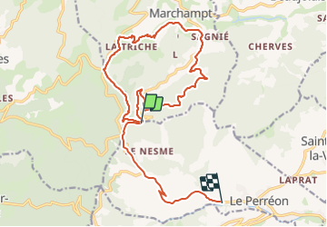
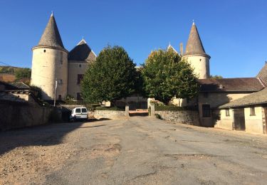
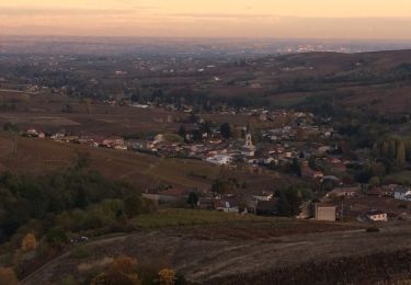
Tour Wandern von 19,4 km verfügbar auf Auvergne-Rhone-Alpen, Rhône, Le Perréon. Diese Tour wird von fernand1254 vorgeschlagen.
Beschreibung
Belle rando, pas de difficulté majeure.
Départ ai dessus du Pérréon par la D88 juste avant d'arriver à la croix Rosier au niveau du virage en. épingle prendre à droite direction Marchampt. Faire 1500m parking à gauche.
Ort
Land:
France
Region :
Auvergne-Rhone-Alpen
Abteilung/Provinz :
Rhône
Kommune :
Le Perréon
Standort:
Unknown
Gehen Sie:(Dec)
Gehen Sie:(UTM)
620312 ; 5104489 (31T) N.
Kommentare
Touren in der Umgebung
![Tour Zu Fuß Vaux-en-Beaujolais - SityTrail - 3843016 - etape-2 - Photo](https://media.geolcdn.com/t/375/260/e854eec2-8ed0-4512-9e04-68895c0881ec.jpg&format=jpg&maxdim=2)
![Zu Fuß Zu Fuß](https://static1.geolcdn.com/sitytour/trail-icons/100.png)
SityTrail - 3843016 - etape-2
Zu Fuß
Sehr schwierig
Vaux-en-Beaujolais,
Auvergne-Rhone-Alpen,
Rhône,
France
![](/images/other/stat-length.png)
22 km | 35 km-effort
7h 58min
![](https://static1.geolcdn.com/siteimages/upload/files/16400158638029165_repeat_loop_refresh_sync_direction_icon.png)
Nein
![Tour Reiten Quincié-en-Beaujolais - Quincié CxRozier Court - Photo](https://media.geolcdn.com/t/375/260/ext.jpg?maxdim=2&url=https%3A%2F%2Fstatic1.geolcdn.com%2Fsiteimages%2Fupload%2Ffiles%2F1524743154cheval.jpg)
![Reiten Reiten](https://static1.geolcdn.com/sitytour/trail-icons/301.png)
Quincié CxRozier Court
Reiten
Sehr schwierig
(1)
Quincié-en-Beaujolais,
Auvergne-Rhone-Alpen,
Rhône,
France
![](/images/other/stat-length.png)
28 km | 42 km-effort
5h 33min
![](https://static1.geolcdn.com/siteimages/upload/files/16400158638029165_repeat_loop_refresh_sync_direction_icon.png)
Ja
![Tour Reiten Quincié-en-Beaujolais - Quincié Croix ROZEIR - Photo](https://media.geolcdn.com/t/375/260/ext.jpg?maxdim=2&url=https%3A%2F%2Fstatic1.geolcdn.com%2Fsiteimages%2Fupload%2Ffiles%2F1524743154cheval.jpg)
![Reiten Reiten](https://static1.geolcdn.com/sitytour/trail-icons/301.png)
Quincié Croix ROZEIR
Reiten
Sehr schwierig
(1)
Quincié-en-Beaujolais,
Auvergne-Rhone-Alpen,
Rhône,
France
![](/images/other/stat-length.png)
31 km | 46 km-effort
6h 3min
![](https://static1.geolcdn.com/siteimages/upload/files/16400158638029165_repeat_loop_refresh_sync_direction_icon.png)
Ja
![Tour Reiten Quincié-en-Beaujolais - Quincié Croix - Photo](https://media.geolcdn.com/t/375/260/ext.jpg?maxdim=2&url=https%3A%2F%2Fstatic1.geolcdn.com%2Fsiteimages%2Fupload%2Ffiles%2F1524743154cheval.jpg)
![Reiten Reiten](https://static1.geolcdn.com/sitytour/trail-icons/301.png)
Quincié Croix
Reiten
Schwierig
(1)
Quincié-en-Beaujolais,
Auvergne-Rhone-Alpen,
Rhône,
France
![](/images/other/stat-length.png)
26 km | 40 km-effort
5h 14min
![](https://static1.geolcdn.com/siteimages/upload/files/16400158638029165_repeat_loop_refresh_sync_direction_icon.png)
Ja
![Tour Wandern Marchampt - 2021-09-04_10h15m01_Marchanp_V1 - Photo](https://media.geolcdn.com/t/375/260/ext.jpg?maxdim=2&url=https%3A%2F%2Fstatic1.geolcdn.com%2Fsiteimages%2Fupload%2Ffiles%2F1553511878bg_sport_marche.png)
![Wandern Wandern](https://static1.geolcdn.com/sitytour/trail-icons/101.png)
2021-09-04_10h15m01_Marchanp_V1
Wandern
Sehr schwierig
(1)
Marchampt,
Auvergne-Rhone-Alpen,
Rhône,
France
![](/images/other/stat-length.png)
19,7 km | 30 km-effort
6h 47min
![](https://static1.geolcdn.com/siteimages/upload/files/16400158638029165_repeat_loop_refresh_sync_direction_icon.png)
Ja
![Tour Wandern Claveisolles - rando autour de Claveisolles - Photo](https://media.geolcdn.com/t/375/260/bf0c1dbf-bf4b-44a0-9fd4-d5de986d160a.jpg&format=jpg&maxdim=2)
![Wandern Wandern](https://static1.geolcdn.com/sitytour/trail-icons/101.png)
rando autour de Claveisolles
Wandern
Einfach
Claveisolles,
Auvergne-Rhone-Alpen,
Rhône,
France
![](/images/other/stat-length.png)
7,3 km | 10,1 km-effort
2h 21min
![](https://static1.geolcdn.com/siteimages/upload/files/16400158638029165_repeat_loop_refresh_sync_direction_icon.png)
Ja
![Tour Wandern Vaux-en-Beaujolais - Vaulx en beaujolais - Photo](https://media.geolcdn.com/t/375/260/5d38e822-f001-465a-8b11-8660c8452a0b.jpg&format=jpg&maxdim=2)
![Wandern Wandern](https://static1.geolcdn.com/sitytour/trail-icons/101.png)
Vaulx en beaujolais
Wandern
Einfach
(1)
Vaux-en-Beaujolais,
Auvergne-Rhone-Alpen,
Rhône,
France
![](/images/other/stat-length.png)
14,3 km | 22 km-effort
4h 25min
![](https://static1.geolcdn.com/siteimages/upload/files/16400158638029165_repeat_loop_refresh_sync_direction_icon.png)
Ja
![Tour Wandern Quincié-en-Beaujolais - Quincié-En-Beaujolais (10,5 km-D.378) - Photo](https://media.geolcdn.com/t/375/260/ext.jpg?maxdim=2&url=https%3A%2F%2Fservices.sitytrail.com%2FGeolivesWS%2FDownloadMedia.ashx%3FTrailID%3D852331%26Media%3D20171026161848.jpg)
![Wandern Wandern](https://static1.geolcdn.com/sitytour/trail-icons/101.png)
Quincié-En-Beaujolais (10,5 km-D.378)
Wandern
Einfach
Quincié-en-Beaujolais,
Auvergne-Rhone-Alpen,
Rhône,
France
![](/images/other/stat-length.png)
10,4 km | 14,8 km-effort
3h 14min
![](https://static1.geolcdn.com/siteimages/upload/files/16400158638029165_repeat_loop_refresh_sync_direction_icon.png)
Ja
![Tour Wandern Le Perréon - le Perréon (69) - Photo](https://media.geolcdn.com/t/375/260/ext.jpg?maxdim=2&url=https%3A%2F%2Fservices.sitytrail.com%2FGeolivesWS%2FDownloadMedia.ashx%3FTrailID%3D661414%26Media%3D20161117165057.jpg)
![Wandern Wandern](https://static1.geolcdn.com/sitytour/trail-icons/101.png)
le Perréon (69)
Wandern
Einfach
Le Perréon,
Auvergne-Rhone-Alpen,
Rhône,
France
![](/images/other/stat-length.png)
10,8 km | 16,5 km-effort
3h 17min
![](https://static1.geolcdn.com/siteimages/upload/files/16400158638029165_repeat_loop_refresh_sync_direction_icon.png)
Ja