![](/images/other/stat-length.png)
![Tour Wandern Nogent-le-Rotrou - Tour des Collines du Perche 1 - Photo](https://media.geolcdn.com/t/1900/400/ext.pjpeg?maxdim=2&url=https%3A%2F%2Fstatic1.geolcdn.com%2Fsiteimages%2Fupload%2Ffiles%2F1553511878bg_sport_marche.png)
Tour des Collines du Perche 1
togolo28
Benutzer
![Länge](/images/other/stat-length.png)
Länge
28 km
![Maximale Höhe](https://static1.geolcdn.com/siteimages/upload/files/1508320355ic_sort_altitude_max_24dp.png)
Maximale Höhe
229 m
![Positive Höhendifferenz](https://static1.geolcdn.com/siteimages/upload/files/1508320355ic_sort_den_pos_24dp.png)
Positive Höhendifferenz
436 m
![Km-Effort](/images/other/stat-length.png)
Km-Effort
33 km
![Min. Höhe](https://static1.geolcdn.com/siteimages/upload/files/1508320355ic_sort_altitude_min_24dp.png)
Min. Höhe
107 m
![Negative Höhendifferenz](https://static1.geolcdn.com/siteimages/upload/files/1508320355ic_sort_den_neg_24dp.png)
Negative Höhendifferenz
409 m
![Boucle](https://static1.geolcdn.com/siteimages/upload/files/16400158638029165_repeat_loop_refresh_sync_direction_icon.png)
Boucle
Nein
Erstellungsdatum :
2016-10-18 00:00:00.0
Letzte Änderung :
2016-10-18 00:00:00.0
![Wandern](https://static1.geolcdn.com/sitytour/trail-icons/101.png)
7h12
Schwierigkeit : Medium
![Scannen Sie diesen QR-Code, um die Tour in der SityTrail-Anwendung zu öffnen](https://capi.geolives.com/qq0zvz2zws4bq2lad0pu/sitytour/trails/381768/qr.png?size=200)
Kostenlosegpshiking-Anwendung
Über SityTrail
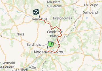
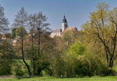
Tour Wandern von 28 km verfügbar auf Zentrum-Loiretal, Eure-et-Loir, Nogent-le-Rotrou. Diese Tour wird von togolo28 vorgeschlagen.
Beschreibung
Le Tour des Collines du Perche à été réalisé par l'association « Itinéraires Ruraux » de Pervenchères (orne). Vous pouvez consulter leur site internet : http://itinerairesduperche.org
Ort
Land:
France
Region :
Zentrum-Loiretal
Abteilung/Provinz :
Eure-et-Loir
Kommune :
Nogent-le-Rotrou
Standort:
Unknown
Gehen Sie:(Dec)
Gehen Sie:(UTM)
337690 ; 5354797 (31U) N.
Kommentare
Touren in der Umgebung
![Tour Wandern Trizay-Coutretot-Saint-Serge - Trizay 100-B - Photo](https://media.geolcdn.com/t/375/260/ext.jpg?maxdim=2&url=https%3A%2F%2Fstatic1.geolcdn.com%2Fsiteimages%2Fupload%2Ffiles%2F1553511878bg_sport_marche.png)
![Wandern Wandern](https://static1.geolcdn.com/sitytour/trail-icons/101.png)
Trizay 100-B
Wandern
Schwierig
(2)
Trizay-Coutretot-Saint-Serge,
Zentrum-Loiretal,
Eure-et-Loir,
France
![](/images/other/stat-length.png)
48 km | 56 km-effort
12h 1min
![](https://static1.geolcdn.com/siteimages/upload/files/16400158638029165_repeat_loop_refresh_sync_direction_icon.png)
Ja
![Tour Wandern Nogent-le-Rotrou - NOGENT LE ROTROU - Photo](https://media.geolcdn.com/t/375/260/c00ba3d7-9b96-49a3-b019-bc489240b465.jpg&format=jpg&maxdim=2)
![Wandern Wandern](https://static1.geolcdn.com/sitytour/trail-icons/101.png)
NOGENT LE ROTROU
Wandern
Medium
Nogent-le-Rotrou,
Zentrum-Loiretal,
Eure-et-Loir,
France
![](/images/other/stat-length.png)
5,8 km | 6,9 km-effort
1h 33min
![](https://static1.geolcdn.com/siteimages/upload/files/16400158638029165_repeat_loop_refresh_sync_direction_icon.png)
Ja
![Tour Wandern Nogent-le-Rotrou - SityTrail - Nogent-le-Rotrou - Saint-Victor-de-Buthon 19 km - Photo](https://media.geolcdn.com/t/375/260/c6e34c0a-1640-462d-a835-4ae8958f9be6.jpg&format=jpg&maxdim=2)
![Wandern Wandern](https://static1.geolcdn.com/sitytour/trail-icons/101.png)
SityTrail - Nogent-le-Rotrou - Saint-Victor-de-Buthon 19 km
Wandern
Sehr schwierig
Nogent-le-Rotrou,
Zentrum-Loiretal,
Eure-et-Loir,
France
![](/images/other/stat-length.png)
19 km | 23 km-effort
5h 5min
![](https://static1.geolcdn.com/siteimages/upload/files/16400158638029165_repeat_loop_refresh_sync_direction_icon.png)
Nein
![Tour Wandern Berd'huis - SityTrail - Berd'huis - Condé-sur-Huisne 14 km - Photo](https://media.geolcdn.com/t/375/260/e562d127-d462-4485-b928-bb7147049073.png&format=jpg&maxdim=2)
![Wandern Wandern](https://static1.geolcdn.com/sitytour/trail-icons/101.png)
SityTrail - Berd'huis - Condé-sur-Huisne 14 km
Wandern
Schwierig
Berd'huis,
Normandie,
Orne,
France
![](/images/other/stat-length.png)
13,9 km | 16,7 km-effort
3h 37min
![](https://static1.geolcdn.com/siteimages/upload/files/16400158638029165_repeat_loop_refresh_sync_direction_icon.png)
Nein
![Tour Wandern Berd'huis - SityTrail - Berd'huis - Saint-Cyr-la-Rosière via Préaux-du-Perche 12 km - Photo](https://media.geolcdn.com/t/375/260/9f597d4c-6499-477b-a914-13f046dbb439.jpg&format=jpg&maxdim=2)
![Wandern Wandern](https://static1.geolcdn.com/sitytour/trail-icons/101.png)
SityTrail - Berd'huis - Saint-Cyr-la-Rosière via Préaux-du-Perche 12 km
Wandern
Sehr leicht
Berd'huis,
Normandie,
Orne,
France
![](/images/other/stat-length.png)
4,1 km | 4,9 km-effort
1h 0min
![](https://static1.geolcdn.com/siteimages/upload/files/16400158638029165_repeat_loop_refresh_sync_direction_icon.png)
Nein
![Tour Wandern Nogent-le-Rotrou - 10981160-ZProjet Nogent - Thiron 2 - Photo](https://media.geolcdn.com/t/375/260/8889b3ec-9799-4b99-8939-6db73505b4bd.jpg&format=jpg&maxdim=2)
![Wandern Wandern](https://static1.geolcdn.com/sitytour/trail-icons/101.png)
10981160-ZProjet Nogent - Thiron 2
Wandern
Sehr schwierig
Nogent-le-Rotrou,
Zentrum-Loiretal,
Eure-et-Loir,
France
![](/images/other/stat-length.png)
22 km | 26 km-effort
6h 0min
![](https://static1.geolcdn.com/siteimages/upload/files/16400158638029165_repeat_loop_refresh_sync_direction_icon.png)
Nein
![Tour Wandern Nogent-le-Rotrou - Nogent-le-Rotrou - Saint-Pierre-la-Bruyère 5,5 km - Photo](https://media.geolcdn.com/t/375/260/eef3d37d-dc69-482d-942f-97ed22dd3c19.jpg&format=jpg&maxdim=2)
![Wandern Wandern](https://static1.geolcdn.com/sitytour/trail-icons/101.png)
Nogent-le-Rotrou - Saint-Pierre-la-Bruyère 5,5 km
Wandern
Einfach
Nogent-le-Rotrou,
Zentrum-Loiretal,
Eure-et-Loir,
France
![](/images/other/stat-length.png)
5,5 km | 6,9 km-effort
3h 42min
![](https://static1.geolcdn.com/siteimages/upload/files/16400158638029165_repeat_loop_refresh_sync_direction_icon.png)
Nein
![Tour Wandern Berd'huis - Bellême - Berd'huis 23 km - Photo](https://media.geolcdn.com/t/375/260/35d6aa94-04a5-460b-b4a9-5d8e7085755b.jpg&format=jpg&maxdim=2)
![Wandern Wandern](https://static1.geolcdn.com/sitytour/trail-icons/101.png)
Bellême - Berd'huis 23 km
Wandern
Schwierig
Berd'huis,
Normandie,
Orne,
France
![](/images/other/stat-length.png)
23 km | 27 km-effort
5h 59min
![](https://static1.geolcdn.com/siteimages/upload/files/16400158638029165_repeat_loop_refresh_sync_direction_icon.png)
Nein
![Tour Wandern Saint-Pierre-la-Bruyère - Condé-sur-Huisne - Saint-Pierre-la-Bruyère via Villeray 8,5 km - Photo](https://media.geolcdn.com/t/375/260/3374e628-d3bf-422a-bb99-175704d9ab1f.jpg&format=jpg&maxdim=2)
![Wandern Wandern](https://static1.geolcdn.com/sitytour/trail-icons/101.png)
Condé-sur-Huisne - Saint-Pierre-la-Bruyère via Villeray 8,5 km
Wandern
Einfach
Saint-Pierre-la-Bruyère,
Normandie,
Orne,
France
![](/images/other/stat-length.png)
8,5 km | 10 km-effort
3h 23min
![](https://static1.geolcdn.com/siteimages/upload/files/16400158638029165_repeat_loop_refresh_sync_direction_icon.png)
Nein