![](/images/other/stat-length.png)
![Tour Wandern Saint-Bonnet-en-Champsaur - Les infournas - Lac des Barbeyroux 22/09/23 - Photo](https://media.geolcdn.com/t/1900/400/0538c280-feb5-4d65-96e8-19b0b69c47f0.jpg&format=pjpeg&maxdim=2)
Les infournas - Lac des Barbeyroux 22/09/23
R@ph
Benutzer GUIDE
![Länge](/images/other/stat-length.png)
![Maximale Höhe](https://static1.geolcdn.com/siteimages/upload/files/1508320355ic_sort_altitude_max_24dp.png)
![Positive Höhendifferenz](https://static1.geolcdn.com/siteimages/upload/files/1508320355ic_sort_den_pos_24dp.png)
![Km-Effort](/images/other/stat-length.png)
![Min. Höhe](https://static1.geolcdn.com/siteimages/upload/files/1508320355ic_sort_altitude_min_24dp.png)
![Negative Höhendifferenz](https://static1.geolcdn.com/siteimages/upload/files/1508320355ic_sort_den_neg_24dp.png)
![Boucle](https://static1.geolcdn.com/siteimages/upload/files/16400158638029165_repeat_loop_refresh_sync_direction_icon.png)
![Wandern](https://static1.geolcdn.com/sitytour/trail-icons/101.png)
3h38
Schwierigkeit : Schwierig
![Scannen Sie diesen QR-Code, um die Tour in der SityTrail-Anwendung zu öffnen](https://capi.geolives.com/qq0zvz2zws4bq2lad0pu/sitytour/trails/3814536/qr.png?size=200)
Kostenlosegpshiking-Anwendung
Über SityTrail
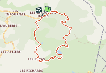
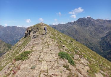
Tour Wandern von 10,1 km verfügbar auf Provence-Alpes-Côte d'Azur, Hochalpen, Saint-Bonnet-en-Champsaur. Diese Tour wird von R@ph vorgeschlagen.
Beschreibung
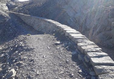
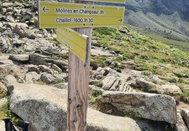
Un parking est disponible au départ des Infournas Hauts dirigez vous vers la maison forestière de Subeyrannes, suivez ensuite le chemin pour arriver au Serre du Moulin. Une barrière est présente sur le chemin de droite prenez à gauche, après une légère montée, vous redescendez ensuite vers le lac des Barbeyroux.
Ort
Kommentare
Touren in der Umgebung
![Tour Wandern La Motte-en-Champsaur - Jas de Jartier - Photo](https://media.geolcdn.com/t/375/260/f77a6a7c-6e5d-40aa-9152-87e370bb16b8.jpg&format=jpg&maxdim=2)
![Wandern Wandern](https://static1.geolcdn.com/sitytour/trail-icons/101.png)
Wandern
![](/images/other/stat-length.png)
![](https://static1.geolcdn.com/siteimages/upload/files/16400158638029165_repeat_loop_refresh_sync_direction_icon.png)
![Tour Wandern Saint-Michel-de-Chaillol - Col de l'Escalier - Photo](https://media.geolcdn.com/t/375/260/ab16f81e-2013-445c-8eb3-48638c0edd61.jpg&format=jpg&maxdim=2)
![Wandern Wandern](https://static1.geolcdn.com/sitytour/trail-icons/101.png)
Wandern
![](/images/other/stat-length.png)
![](https://static1.geolcdn.com/siteimages/upload/files/16400158638029165_repeat_loop_refresh_sync_direction_icon.png)
![Tour Wandern Saint-Michel-de-Chaillol - Pic Queyrel - Photo](https://media.geolcdn.com/t/375/260/3587472a-93b3-4434-9291-823cc836fe6a.jpg&format=jpg&maxdim=2)
![Wandern Wandern](https://static1.geolcdn.com/sitytour/trail-icons/101.png)
Wandern
![](/images/other/stat-length.png)
![](https://static1.geolcdn.com/siteimages/upload/files/16400158638029165_repeat_loop_refresh_sync_direction_icon.png)
![Tour Wandern Saint-Michel-de-Chaillol - Pic du Tourond - Photo](https://media.geolcdn.com/t/375/260/01ce6341-dc1d-4078-9a13-caf8c777653c.jpg&format=jpg&maxdim=2)
![Wandern Wandern](https://static1.geolcdn.com/sitytour/trail-icons/101.png)
Wandern
![](/images/other/stat-length.png)
![](https://static1.geolcdn.com/siteimages/upload/files/16400158638029165_repeat_loop_refresh_sync_direction_icon.png)
![Tour Wandern Saint-Michel-de-Chaillol - Lac de Malcros - Photo](https://media.geolcdn.com/t/375/260/6a7a1b5d-0b23-46a5-9179-bf8c821d0afb.jpg&format=jpg&maxdim=2)
![Wandern Wandern](https://static1.geolcdn.com/sitytour/trail-icons/101.png)
Wandern
![](/images/other/stat-length.png)
![](https://static1.geolcdn.com/siteimages/upload/files/16400158638029165_repeat_loop_refresh_sync_direction_icon.png)
![Tour Wandern Saint-Michel-de-Chaillol - pic de queyrel - Photo](https://media.geolcdn.com/t/375/260/16bf5dfe-1e8f-41f7-8280-542f457efdf9.jpg&format=jpg&maxdim=2)
![Wandern Wandern](https://static1.geolcdn.com/sitytour/trail-icons/101.png)
Wandern
![](/images/other/stat-length.png)
![](https://static1.geolcdn.com/siteimages/upload/files/16400158638029165_repeat_loop_refresh_sync_direction_icon.png)
![Tour Wandern Saint-Michel-de-Chaillol - Tête ouest de Mal Cros 11/08/18 - Photo](https://media.geolcdn.com/t/375/260/8702d498-6db2-40a6-b115-ed3ce3d7c0b6.jpg&format=jpg&maxdim=2)
![Wandern Wandern](https://static1.geolcdn.com/sitytour/trail-icons/101.png)
Wandern
![](/images/other/stat-length.png)
![](https://static1.geolcdn.com/siteimages/upload/files/16400158638029165_repeat_loop_refresh_sync_direction_icon.png)
![Tour Wandern Saint-Michel-de-Chaillol - col de la pisse - Photo](https://media.geolcdn.com/t/375/260/8e690fd3-f0ad-4120-9a92-3c8fe4646f31.jpg&format=jpg&maxdim=2)
![Wandern Wandern](https://static1.geolcdn.com/sitytour/trail-icons/101.png)
Wandern
![](/images/other/stat-length.png)
![](https://static1.geolcdn.com/siteimages/upload/files/16400158638029165_repeat_loop_refresh_sync_direction_icon.png)
![Tour Wandern Saint-Michel-de-Chaillol - Pic Queyrel 2435m 3.8.24 - Photo](https://media.geolcdn.com/t/375/260/fd697448-1d28-4c85-90d7-854b061fcf83.jpg&format=jpg&maxdim=2)
![Wandern Wandern](https://static1.geolcdn.com/sitytour/trail-icons/101.png)
Wandern
![](/images/other/stat-length.png)
![](https://static1.geolcdn.com/siteimages/upload/files/16400158638029165_repeat_loop_refresh_sync_direction_icon.png)