![](/images/other/stat-length.png)
![Tour Wandern Bassens - St Saturnin-Tilleret-18-09-23 - Photo](https://media.geolcdn.com/t/1900/400/ext.pjpeg?maxdim=2&url=https%3A%2F%2Fstatic1.geolcdn.com%2Fsiteimages%2Fupload%2Ffiles%2F1553511878bg_sport_marche.png)
St Saturnin-Tilleret-18-09-23
papou73
Benutzer
![Länge](/images/other/stat-length.png)
Länge
7,3 km
![Maximale Höhe](https://static1.geolcdn.com/siteimages/upload/files/1508320355ic_sort_altitude_max_24dp.png)
Maximale Höhe
563 m
![Positive Höhendifferenz](https://static1.geolcdn.com/siteimages/upload/files/1508320355ic_sort_den_pos_24dp.png)
Positive Höhendifferenz
305 m
![Km-Effort](/images/other/stat-length.png)
Km-Effort
11,4 km
![Min. Höhe](https://static1.geolcdn.com/siteimages/upload/files/1508320355ic_sort_altitude_min_24dp.png)
Min. Höhe
317 m
![Negative Höhendifferenz](https://static1.geolcdn.com/siteimages/upload/files/1508320355ic_sort_den_neg_24dp.png)
Negative Höhendifferenz
306 m
![Boucle](https://static1.geolcdn.com/siteimages/upload/files/16400158638029165_repeat_loop_refresh_sync_direction_icon.png)
Boucle
Ja
Erstellungsdatum :
2023-09-18 07:29:17.044
Letzte Änderung :
2023-09-18 07:36:11.623
![Wandern](https://static1.geolcdn.com/sitytour/trail-icons/101.png)
2h35
Schwierigkeit : Medium
![Scannen Sie diesen QR-Code, um die Tour in der SityTrail-Anwendung zu öffnen](https://capi.geolives.com/qq0zvz2zws4bq2lad0pu/sitytour/trails/3810172/qr.png?size=200)
Kostenlosegpshiking-Anwendung
Über SityTrail
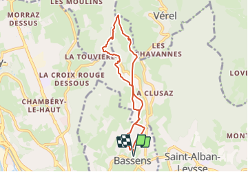
Tour Wandern von 7,3 km verfügbar auf Auvergne-Rhone-Alpen, Savoyen, Bassens. Diese Tour wird von papou73 vorgeschlagen.
Beschreibung
Au départ du parking Espace colombe (église de Bassens) circuit par la chapelle St Saturnin, le roc Mandrin, le Tilleret, la croix de bon secours, la Clusaz et retour Bassens.
Ort
Land:
France
Region :
Auvergne-Rhone-Alpen
Abteilung/Provinz :
Savoyen
Kommune :
Bassens
Standort:
Unknown
Gehen Sie:(Dec)
Gehen Sie:(UTM)
729438 ; 5051844 (31T) N.
Kommentare
Touren in der Umgebung
![Tour Laufen Saint-Jean-d'Arvey - Tour du plateau de la Leysse - Photo](https://media.geolcdn.com/t/375/260/ext.jpg?maxdim=2&url=https%3A%2F%2Fservices.sitytrail.com%2FGeolivesWS%2FDownloadMedia.ashx%3FTrailID%3D127434%26Media%3D08a8806c-d534-407b-8c02-e91e2473a9c8.JPG)
![Laufen Laufen](https://static1.geolcdn.com/sitytour/trail-icons/103.png)
Tour du plateau de la Leysse
Laufen
Sehr leicht
(1)
Saint-Jean-d'Arvey,
Auvergne-Rhone-Alpen,
Savoyen,
France
![](/images/other/stat-length.png)
47 km | 82 km-effort
10h 0min
![](https://static1.geolcdn.com/siteimages/upload/files/16400158638029165_repeat_loop_refresh_sync_direction_icon.png)
Ja
![Tour Wandern Challes-les-Eaux - Le Mont Saint-Michel 895 m, depuis Challes-les-Eaux - Photo](https://media.geolcdn.com/t/375/260/ext.jpg?maxdim=2&url=https%3A%2F%2Fservices.sitytrail.com%2FGeolivesWS%2FDownloadMedia.ashx%3FTrailID%3D191627%26Media%3D15268_1.jpg)
![Wandern Wandern](https://static1.geolcdn.com/sitytour/trail-icons/101.png)
Le Mont Saint-Michel 895 m, depuis Challes-les-Eaux
Wandern
Schwierig
(1)
Challes-les-Eaux,
Auvergne-Rhone-Alpen,
Savoyen,
France
![](/images/other/stat-length.png)
7,6 km | 15 km-effort
4h 15min
![](https://static1.geolcdn.com/siteimages/upload/files/16400158638029165_repeat_loop_refresh_sync_direction_icon.png)
Ja
![Tour Mountainbike Bassens - Pragondra - Photo](https://media.geolcdn.com/t/375/260/ext.jpg?maxdim=2&url=https%3A%2F%2Fservices.sitytrail.com%2FGeolivesWS%2FDownloadMedia.ashx%3FTrailID%3D147927%26Media%3D20120818110710.jpg)
![Mountainbike Mountainbike](https://static1.geolcdn.com/sitytour/trail-icons/202.png)
Pragondra
Mountainbike
Sehr leicht
(1)
Bassens,
Auvergne-Rhone-Alpen,
Savoyen,
France
![](/images/other/stat-length.png)
24 km | 34 km-effort
2h 49min
![](https://static1.geolcdn.com/siteimages/upload/files/16400158638029165_repeat_loop_refresh_sync_direction_icon.png)
Nein
![Tour Mountainbike Cognin - Autour du Corbeley - Photo](https://media.geolcdn.com/t/375/260/ext.jpg?maxdim=2&url=https%3A%2F%2Fstatic1.geolcdn.com%2Fsiteimages%2Fupload%2Ffiles%2F1524743154velo.jpg)
![Mountainbike Mountainbike](https://static1.geolcdn.com/sitytour/trail-icons/202.png)
Autour du Corbeley
Mountainbike
Medium
(1)
Cognin,
Auvergne-Rhone-Alpen,
Savoyen,
France
![](/images/other/stat-length.png)
25 km | 38 km-effort
2h 23min
![](https://static1.geolcdn.com/siteimages/upload/files/16400158638029165_repeat_loop_refresh_sync_direction_icon.png)
Ja
![Tour Wandern Saint-Alban-Leysse - 73- Le chemin des poussettes - Photo](https://media.geolcdn.com/t/375/260/ext.jpg?maxdim=2&url=https%3A%2F%2Fstatic1.geolcdn.com%2Fsiteimages%2Fupload%2Ffiles%2F1553511878bg_sport_marche.png)
![Wandern Wandern](https://static1.geolcdn.com/sitytour/trail-icons/101.png)
73- Le chemin des poussettes
Wandern
Einfach
(1)
Saint-Alban-Leysse,
Auvergne-Rhone-Alpen,
Savoyen,
France
![](/images/other/stat-length.png)
4,9 km | 10,6 km-effort
2h 2min
![](https://static1.geolcdn.com/siteimages/upload/files/16400158638029165_repeat_loop_refresh_sync_direction_icon.png)
Ja
![Tour Mountainbike Saint-Alban-Leysse - 2012-03-24 - Malpassant+ St sat - Photo](https://media.geolcdn.com/t/375/260/ext.jpg?maxdim=2&url=https%3A%2F%2Fstatic1.geolcdn.com%2Fsiteimages%2Fupload%2Ffiles%2F1524743154velo.jpg)
![Mountainbike Mountainbike](https://static1.geolcdn.com/sitytour/trail-icons/202.png)
2012-03-24 - Malpassant+ St sat
Mountainbike
Medium
(1)
Saint-Alban-Leysse,
Auvergne-Rhone-Alpen,
Savoyen,
France
![](/images/other/stat-length.png)
27 km | 44 km-effort
3h 2min
![](https://static1.geolcdn.com/siteimages/upload/files/16400158638029165_repeat_loop_refresh_sync_direction_icon.png)
Ja
![Tour Wandern Les Déserts - Nivolet - Photo](https://media.geolcdn.com/t/375/260/048cf6ab-404d-4bce-bd74-e2c4ccef4fd8.jpg&format=jpg&maxdim=2)
![Wandern Wandern](https://static1.geolcdn.com/sitytour/trail-icons/101.png)
Nivolet
Wandern
Medium
Les Déserts,
Auvergne-Rhone-Alpen,
Savoyen,
France
![](/images/other/stat-length.png)
8,5 km | 19 km-effort
5h 29min
![](https://static1.geolcdn.com/siteimages/upload/files/16400158638029165_repeat_loop_refresh_sync_direction_icon.png)
Ja
![Tour Hybrid-Bike Cognin - Chambéry jujurieux - Photo](https://media.geolcdn.com/t/375/260/718fb78c-ba3a-4f4f-9193-923a356e563d.jpg&format=jpg&maxdim=2)
![Hybrid-Bike Hybrid-Bike](https://static1.geolcdn.com/sitytour/trail-icons/203.png)
Chambéry jujurieux
Hybrid-Bike
Schwierig
Cognin,
Auvergne-Rhone-Alpen,
Savoyen,
France
![](/images/other/stat-length.png)
123 km | 143 km-effort
7h 30min
![](https://static1.geolcdn.com/siteimages/upload/files/16400158638029165_repeat_loop_refresh_sync_direction_icon.png)
Nein
![Tour Wandern Les Déserts - CROIX DU NIVOLET depuis maison brûlée - Photo](https://media.geolcdn.com/t/375/260/91c62f02-6ade-47f8-b1f4-e1f1b7b238a1.jpg&format=jpg&maxdim=2)
![Wandern Wandern](https://static1.geolcdn.com/sitytour/trail-icons/101.png)
CROIX DU NIVOLET depuis maison brûlée
Wandern
Schwierig
Les Déserts,
Auvergne-Rhone-Alpen,
Savoyen,
France
![](/images/other/stat-length.png)
11,1 km | 23 km-effort
7h 42min
![](https://static1.geolcdn.com/siteimages/upload/files/16400158638029165_repeat_loop_refresh_sync_direction_icon.png)
Ja