![](/images/other/stat-length.png)
![Tour Wandern Lennik - gaasbeek (départ du parking du château) - Photo](https://media.geolcdn.com/t/1900/400/b65667a1-6a17-4664-a23a-2140eac1eacf.jpg&format=pjpeg&maxdim=2)
gaasbeek (départ du parking du château)
ELISECRO
Benutzer
![Länge](/images/other/stat-length.png)
Länge
7,2 km
![Maximale Höhe](https://static1.geolcdn.com/siteimages/upload/files/1508320355ic_sort_altitude_max_24dp.png)
Maximale Höhe
88 m
![Positive Höhendifferenz](https://static1.geolcdn.com/siteimages/upload/files/1508320355ic_sort_den_pos_24dp.png)
Positive Höhendifferenz
103 m
![Km-Effort](/images/other/stat-length.png)
Km-Effort
8,6 km
![Min. Höhe](https://static1.geolcdn.com/siteimages/upload/files/1508320355ic_sort_altitude_min_24dp.png)
Min. Höhe
31 m
![Negative Höhendifferenz](https://static1.geolcdn.com/siteimages/upload/files/1508320355ic_sort_den_neg_24dp.png)
Negative Höhendifferenz
111 m
![Boucle](https://static1.geolcdn.com/siteimages/upload/files/16400158638029165_repeat_loop_refresh_sync_direction_icon.png)
Boucle
Nein
Erstellungsdatum :
2023-09-14 08:17:30.894
Letzte Änderung :
2024-05-13 14:06:29.209
![Wandern](https://static1.geolcdn.com/sitytour/trail-icons/101.png)
1h57
Schwierigkeit : Medium
![Scannen Sie diesen QR-Code, um die Tour in der SityTrail-Anwendung zu öffnen](https://capi.geolives.com/qq0zvz2zws4bq2lad0pu/sitytour/trails/3805904/qr.png?size=200)
Kostenlosegpshiking-Anwendung
Über SityTrail
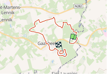
Tour Wandern von 7,2 km verfügbar auf Flandern, Flämisch-Brabant, Lennik. Diese Tour wird von ELISECRO vorgeschlagen.
Beschreibung
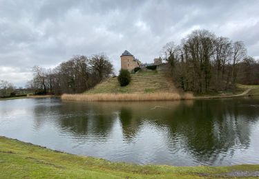
promenade dans le domaine du château du GROENENBERG et ensuite sentiers et petits chemins dans le pajottenland; retour par le domaine du château de GAASBEEK (parcours complet à l'arrière de celui-ci par les étangs , le ruisseau et les bois et remontée vers le château)
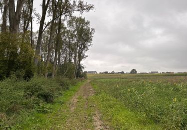
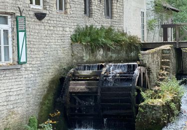
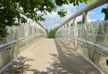
Ort
Land:
Belgium
Region :
Flandern
Abteilung/Provinz :
Flämisch-Brabant
Kommune :
Lennik
Standort:
Gaasbeek
Gehen Sie:(Dec)
Gehen Sie:(UTM)
584684 ; 5628257 (31U) N.
Kommentare
Touren in der Umgebung
![Tour Wandern Lennik - Autour de Gaasbeek - Photo](https://media.geolcdn.com/t/375/260/5c335b1b-d34f-4c3a-9430-6e6f640c8bc4.jpg&format=jpg&maxdim=2)
![Wandern Wandern](https://static1.geolcdn.com/sitytour/trail-icons/101.png)
Autour de Gaasbeek
Wandern
Einfach
(1)
Lennik,
Flandern,
Flämisch-Brabant,
Belgium
![](/images/other/stat-length.png)
9,1 km | 10,9 km-effort
2h 10min
![](https://static1.geolcdn.com/siteimages/upload/files/16400158638029165_repeat_loop_refresh_sync_direction_icon.png)
Ja
![Tour Wandern Sint-Pieters-Leeuw - pajottenland_0521 - Photo](https://media.geolcdn.com/t/375/260/ext.jpg?maxdim=2&url=https%3A%2F%2Fstatic1.geolcdn.com%2Fsiteimages%2Fupload%2Ffiles%2F1553511878bg_sport_marche.png)
![Wandern Wandern](https://static1.geolcdn.com/sitytour/trail-icons/101.png)
pajottenland_0521
Wandern
Medium
(1)
Sint-Pieters-Leeuw,
Flandern,
Flämisch-Brabant,
Belgium
![](/images/other/stat-length.png)
8,7 km | 9,7 km-effort
2h 14min
![](https://static1.geolcdn.com/siteimages/upload/files/16400158638029165_repeat_loop_refresh_sync_direction_icon.png)
Ja
![Tour Wandern Sint-Pieters-Leeuw - Leeuw Saint Pierre 21,6 km - Photo](https://media.geolcdn.com/t/375/260/d1761a3a-5d29-4e75-930e-e4d45b33cda9.jpg&format=jpg&maxdim=2)
![Wandern Wandern](https://static1.geolcdn.com/sitytour/trail-icons/101.png)
Leeuw Saint Pierre 21,6 km
Wandern
Einfach
Sint-Pieters-Leeuw,
Flandern,
Flämisch-Brabant,
Belgium
![](/images/other/stat-length.png)
22 km | 25 km-effort
5h 49min
![](https://static1.geolcdn.com/siteimages/upload/files/16400158638029165_repeat_loop_refresh_sync_direction_icon.png)
Ja
![Tour Wandern Lennik - Gaasbeeck matin - Photo](https://media.geolcdn.com/t/375/260/ext.jpg?maxdim=2&url=https%3A%2F%2Fstatic1.geolcdn.com%2Fsiteimages%2Fupload%2Ffiles%2F1553511878bg_sport_marche.png)
![Wandern Wandern](https://static1.geolcdn.com/sitytour/trail-icons/101.png)
Gaasbeeck matin
Wandern
Sehr leicht
(3)
Lennik,
Flandern,
Flämisch-Brabant,
Belgium
![](/images/other/stat-length.png)
9,4 km | 10,8 km-effort
2h 34min
![](https://static1.geolcdn.com/siteimages/upload/files/16400158638029165_repeat_loop_refresh_sync_direction_icon.png)
Ja
![Tour Zu Fuß Anderlecht - Bruegel route (du resto den Appelboom) - Photo](https://media.geolcdn.com/t/375/260/ext.jpg?maxdim=2&url=https%3A%2F%2Fstatic1.geolcdn.com%2Fsiteimages%2Fupload%2Ffiles%2F1545311037marcheuse_200dpi.jpg)
![Zu Fuß Zu Fuß](https://static1.geolcdn.com/sitytour/trail-icons/100.png)
Bruegel route (du resto den Appelboom)
Zu Fuß
Einfach
(1)
Anderlecht,
Brüssel-Hauptstadt,
Unbekannt,
Belgium
![](/images/other/stat-length.png)
8,2 km | 9,7 km-effort
Unbekannt
![](https://static1.geolcdn.com/siteimages/upload/files/16400158638029165_repeat_loop_refresh_sync_direction_icon.png)
Ja
![Tour Wandern Lennik - schepdaal 14 km - Photo](https://media.geolcdn.com/t/375/260/ext.jpg?maxdim=2&url=https%3A%2F%2Fstatic1.geolcdn.com%2Fsiteimages%2Fupload%2Ffiles%2F1553511878bg_sport_marche.png)
![Wandern Wandern](https://static1.geolcdn.com/sitytour/trail-icons/101.png)
schepdaal 14 km
Wandern
Sehr leicht
(1)
Lennik,
Flandern,
Flämisch-Brabant,
Belgium
![](/images/other/stat-length.png)
14,2 km | 16,9 km-effort
2h 58min
![](https://static1.geolcdn.com/siteimages/upload/files/16400158638029165_repeat_loop_refresh_sync_direction_icon.png)
Ja
![Tour Wandern Lennik - Sint Martens Lennik 7,9 km - Photo](https://media.geolcdn.com/t/375/260/1ff1b843-1bd4-4c35-9997-d2a88eb92555.jpg&format=jpg&maxdim=2)
![Wandern Wandern](https://static1.geolcdn.com/sitytour/trail-icons/101.png)
Sint Martens Lennik 7,9 km
Wandern
Einfach
Lennik,
Flandern,
Flämisch-Brabant,
Belgium
![](/images/other/stat-length.png)
7,9 km | 8,8 km-effort
1h 59min
![](https://static1.geolcdn.com/siteimages/upload/files/16400158638029165_repeat_loop_refresh_sync_direction_icon.png)
Ja
![Tour Rennrad Sint-Pieters-Leeuw - La promenade verte autour de Bruxelles - Photo](https://media.geolcdn.com/t/375/260/6ea46bbe-3105-4327-905a-f71e3260e1e4.jpg&format=jpg&maxdim=2)
![Rennrad Rennrad](https://static1.geolcdn.com/sitytour/trail-icons/201.png)
La promenade verte autour de Bruxelles
Rennrad
Medium
Sint-Pieters-Leeuw,
Flandern,
Flämisch-Brabant,
Belgium
![](/images/other/stat-length.png)
65 km | 75 km-effort
9h 57min
![](https://static1.geolcdn.com/siteimages/upload/files/16400158638029165_repeat_loop_refresh_sync_direction_icon.png)
Ja
![Tour Wandern Dilbeek - Sint Anna Pede petit tour - Photo](https://media.geolcdn.com/t/375/260/21da7e7d-422b-4f67-9990-46a447269bd4.jpg&format=jpg&maxdim=2)
![Wandern Wandern](https://static1.geolcdn.com/sitytour/trail-icons/101.png)
Sint Anna Pede petit tour
Wandern
Sehr leicht
Dilbeek,
Flandern,
Flämisch-Brabant,
Belgium
![](/images/other/stat-length.png)
7,5 km | 8,1 km-effort
2h 9min
![](https://static1.geolcdn.com/siteimages/upload/files/16400158638029165_repeat_loop_refresh_sync_direction_icon.png)
Ja