![](/images/other/stat-length.png)
![Tour Mountainbike Gréasque - De Gréasque autour de Belcodène - Photo](https://media.geolcdn.com/t/1900/400/ext.pjpeg?maxdim=2&url=https%3A%2F%2Fstatic1.geolcdn.com%2Fsiteimages%2Fupload%2Ffiles%2F1524743154velo.jpg)
De Gréasque autour de Belcodène
Coqorico
Benutzer
![Länge](/images/other/stat-length.png)
Länge
27 km
![Maximale Höhe](https://static1.geolcdn.com/siteimages/upload/files/1508320355ic_sort_altitude_max_24dp.png)
Maximale Höhe
453 m
![Positive Höhendifferenz](https://static1.geolcdn.com/siteimages/upload/files/1508320355ic_sort_den_pos_24dp.png)
Positive Höhendifferenz
543 m
![Km-Effort](/images/other/stat-length.png)
Km-Effort
34 km
![Min. Höhe](https://static1.geolcdn.com/siteimages/upload/files/1508320355ic_sort_altitude_min_24dp.png)
Min. Höhe
273 m
![Negative Höhendifferenz](https://static1.geolcdn.com/siteimages/upload/files/1508320355ic_sort_den_neg_24dp.png)
Negative Höhendifferenz
544 m
![Boucle](https://static1.geolcdn.com/siteimages/upload/files/16400158638029165_repeat_loop_refresh_sync_direction_icon.png)
Boucle
Ja
Erstellungsdatum :
2016-04-03 00:00:00.0
Letzte Änderung :
2016-04-03 00:00:00.0
![Mountainbike](https://static1.geolcdn.com/sitytour/trail-icons/202.png)
2h12
Schwierigkeit : Medium
![Scannen Sie diesen QR-Code, um die Tour in der SityTrail-Anwendung zu öffnen](https://capi.geolives.com/qq0zvz2zws4bq2lad0pu/sitytour/trails/380255/qr.png?size=200)
Kostenlosegpshiking-Anwendung
Über SityTrail
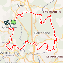
Tour Mountainbike von 27 km verfügbar auf Provence-Alpes-Côte d'Azur, Bouches-du-Rhône, Gréasque. Diese Tour wird von Coqorico vorgeschlagen.
Beschreibung
Boucle d'un peu plus de 2h.
Des variantes sont possibles, essentiellement pour la raccourcir ou réduire la difficulté, elles sont signalées via des POI.
POIs
Ort
Land:
France
Region :
Provence-Alpes-Côte d'Azur
Abteilung/Provinz :
Bouches-du-Rhône
Kommune :
Gréasque
Standort:
Unknown
Gehen Sie:(Dec)
Gehen Sie:(UTM)
705964 ; 4811876 (31T) N.
Kommentare
Touren in der Umgebung
![Mountainbike Mountainbike](https://static1.geolcdn.com/sitytour/trail-icons/202.png)
Le Regagnas par Belcodène retour par Kirbon et Les Michels D+715m
Mountainbike
Sehr schwierig
(1)
Fuveau,
Provence-Alpes-Côte d'Azur,
Bouches-du-Rhône,
France
![](/images/other/stat-length.png)
33 km | 43 km-effort
2h 59min
![](https://static1.geolcdn.com/siteimages/upload/files/16400158638029165_repeat_loop_refresh_sync_direction_icon.png)
Ja
![Wandern Wandern](https://static1.geolcdn.com/sitytour/trail-icons/101.png)
Canal par le chemin de fer
Wandern
Sehr schwierig
(1)
Fuveau,
Provence-Alpes-Côte d'Azur,
Bouches-du-Rhône,
France
![](/images/other/stat-length.png)
16,8 km | 21 km-effort
4h 40min
![](https://static1.geolcdn.com/siteimages/upload/files/16400158638029165_repeat_loop_refresh_sync_direction_icon.png)
Ja
![Mountainbike Mountainbike](https://static1.geolcdn.com/sitytour/trail-icons/202.png)
La corniche des 2 barrages de Ste Victoire
Mountainbike
Sehr schwierig
(1)
Fuveau,
Provence-Alpes-Côte d'Azur,
Bouches-du-Rhône,
France
![](/images/other/stat-length.png)
35 km | 45 km-effort
3h 7min
![](https://static1.geolcdn.com/siteimages/upload/files/16400158638029165_repeat_loop_refresh_sync_direction_icon.png)
Ja
![Rennrad Rennrad](https://static1.geolcdn.com/sitytour/trail-icons/201.png)
Vallée de l'Arc et retour par Pourrières Puyloubier Chateauneuf
Rennrad
Sehr schwierig
(1)
Fuveau,
Provence-Alpes-Côte d'Azur,
Bouches-du-Rhône,
France
![](/images/other/stat-length.png)
42 km | 47 km-effort
2h 52min
![](https://static1.geolcdn.com/siteimages/upload/files/16400158638029165_repeat_loop_refresh_sync_direction_icon.png)
Ja
![Mountainbike Mountainbike](https://static1.geolcdn.com/sitytour/trail-icons/202.png)
4 Termes, Chateau-bas, Siminane, Pilon, Col St-Anne, Mimet, Gréasque
Mountainbike
Sehr schwierig
(1)
Fuveau,
Provence-Alpes-Côte d'Azur,
Bouches-du-Rhône,
France
![](/images/other/stat-length.png)
36 km | 47 km-effort
3h 13min
![](https://static1.geolcdn.com/siteimages/upload/files/16400158638029165_repeat_loop_refresh_sync_direction_icon.png)
Ja
![Wandern Wandern](https://static1.geolcdn.com/sitytour/trail-icons/101.png)
La centrale photovoltaique par le chemin de fer
Wandern
Schwierig
(1)
Fuveau,
Provence-Alpes-Côte d'Azur,
Bouches-du-Rhône,
France
![](/images/other/stat-length.png)
10,1 km | 12,6 km-effort
2h 52min
![](https://static1.geolcdn.com/siteimages/upload/files/16400158638029165_repeat_loop_refresh_sync_direction_icon.png)
Ja
![Rennrad Rennrad](https://static1.geolcdn.com/sitytour/trail-icons/201.png)
Tour Ste Victoire D+1200m
Rennrad
Sehr schwierig
(1)
Fuveau,
Provence-Alpes-Côte d'Azur,
Bouches-du-Rhône,
France
![](/images/other/stat-length.png)
72 km | 88 km-effort
5h 21min
![](https://static1.geolcdn.com/siteimages/upload/files/16400158638029165_repeat_loop_refresh_sync_direction_icon.png)
Ja
![Mountainbike Mountainbike](https://static1.geolcdn.com/sitytour/trail-icons/202.png)
Fuveau, Regagnas, La Couelle, Kirbon, Les Michels, Fuveau D+790m
Mountainbike
Sehr schwierig
(1)
Fuveau,
Provence-Alpes-Côte d'Azur,
Bouches-du-Rhône,
France
![](/images/other/stat-length.png)
38 km | 49 km-effort
3h 24min
![](https://static1.geolcdn.com/siteimages/upload/files/16400158638029165_repeat_loop_refresh_sync_direction_icon.png)
Ja
![Rennrad Rennrad](https://static1.geolcdn.com/sitytour/trail-icons/201.png)
Maison de la Ste Victoire D+590m
Rennrad
Sehr schwierig
(1)
Fuveau,
Provence-Alpes-Côte d'Azur,
Bouches-du-Rhône,
France
![](/images/other/stat-length.png)
36 km | 44 km-effort
2h 40min
![](https://static1.geolcdn.com/siteimages/upload/files/16400158638029165_repeat_loop_refresh_sync_direction_icon.png)
Ja