![](/images/other/stat-length.png)
![Tour Wandern Pierre-la-Treiche - Pierre la Treiche - Photo](https://media.geolcdn.com/t/1900/400/ext.pjpeg?maxdim=2&url=https%3A%2F%2Fstatic1.geolcdn.com%2Fsiteimages%2Fupload%2Ffiles%2F1553511878bg_sport_marche.png)
Pierre la Treiche
joelclaudel
Benutzer
![Länge](/images/other/stat-length.png)
Länge
12,2 km
![Maximale Höhe](https://static1.geolcdn.com/siteimages/upload/files/1508320355ic_sort_altitude_max_24dp.png)
Maximale Höhe
254 m
![Positive Höhendifferenz](https://static1.geolcdn.com/siteimages/upload/files/1508320355ic_sort_den_pos_24dp.png)
Positive Höhendifferenz
106 m
![Km-Effort](/images/other/stat-length.png)
Km-Effort
13,6 km
![Min. Höhe](https://static1.geolcdn.com/siteimages/upload/files/1508320355ic_sort_altitude_min_24dp.png)
Min. Höhe
200 m
![Negative Höhendifferenz](https://static1.geolcdn.com/siteimages/upload/files/1508320355ic_sort_den_neg_24dp.png)
Negative Höhendifferenz
106 m
![Boucle](https://static1.geolcdn.com/siteimages/upload/files/16400158638029165_repeat_loop_refresh_sync_direction_icon.png)
Boucle
Ja
Erstellungsdatum :
2015-01-28 00:00:00.0
Letzte Änderung :
2015-01-28 00:00:00.0
![Wandern](https://static1.geolcdn.com/sitytour/trail-icons/101.png)
3h02
Schwierigkeit : Einfach
![Scannen Sie diesen QR-Code, um die Tour in der SityTrail-Anwendung zu öffnen](https://capi.geolives.com/qq0zvz2zws4bq2lad0pu/sitytour/trails/379530/qr.png?size=200)
Kostenlosegpshiking-Anwendung
Über SityTrail
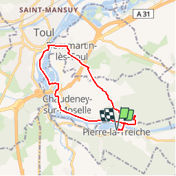
Tour Wandern von 12,2 km verfügbar auf Großer Osten, Mörthe und Mosel, Pierre-la-Treiche. Diese Tour wird von joelclaudel vorgeschlagen.
Beschreibung
Départ parking terrain de foot Pierre la Treiche.
Traverser la Moselle et prendre immédiatement à gauche (balisage rectangle jaune).
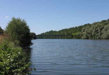
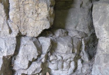
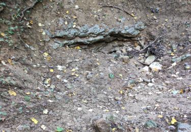
Passage par Chaudeney, Toul, puis GR 5, Dommartin les Toul, Forêt de Pierre la Treiche, grottes Ste Reine.l
Ort
Land:
France
Region :
Großer Osten
Abteilung/Provinz :
Mörthe und Mosel
Kommune :
Pierre-la-Treiche
Standort:
Unknown
Gehen Sie:(Dec)
Gehen Sie:(UTM)
715869 ; 5392007 (31U) N.
Kommentare
Touren in der Umgebung
![Tour Mountainbike Toul - Côtes de Toul 50k 2012 - Photo](https://media.geolcdn.com/t/375/260/ext.jpg?maxdim=2&url=https%3A%2F%2Fstatic1.geolcdn.com%2Fsiteimages%2Fupload%2Ffiles%2F1524743154velo.jpg)
![Mountainbike Mountainbike](https://static1.geolcdn.com/sitytour/trail-icons/202.png)
Côtes de Toul 50k 2012
Mountainbike
Schwierig
(2)
Toul,
Großer Osten,
Mörthe und Mosel,
France
![](/images/other/stat-length.png)
59 km | 75 km-effort
5h 15min
![](https://static1.geolcdn.com/siteimages/upload/files/16400158638029165_repeat_loop_refresh_sync_direction_icon.png)
Ja
![Tour Pferd Villey-le-Sec - La Poudrière - Villey le Sec - Photo](https://media.geolcdn.com/t/375/260/ext.jpg?maxdim=2&url=https%3A%2F%2Fstatic1.geolcdn.com%2Fsiteimages%2Fupload%2Ffiles%2F1524743154cheval.jpg)
![Pferd Pferd](https://static1.geolcdn.com/sitytour/trail-icons/300.png)
La Poudrière - Villey le Sec
Pferd
Medium
(1)
Villey-le-Sec,
Großer Osten,
Mörthe und Mosel,
France
![](/images/other/stat-length.png)
8,6 km | 10,7 km-effort
1h 30min
![](https://static1.geolcdn.com/siteimages/upload/files/16400158638029165_repeat_loop_refresh_sync_direction_icon.png)
Ja
![Tour Zu Fuß Dommartin-lès-Toul - Circuit du Luxembourg - Photo](https://media.geolcdn.com/t/375/260/ext.jpg?maxdim=2&url=https%3A%2F%2Fmedia.geolcdn.com%2Ff%2F0b892edf-20a9-4dc3-9c45-de322eacd10b.jpeg)
![Zu Fuß Zu Fuß](https://static1.geolcdn.com/sitytour/trail-icons/100.png)
Circuit du Luxembourg
Zu Fuß
Einfach
Dommartin-lès-Toul,
Großer Osten,
Mörthe und Mosel,
France
![](/images/other/stat-length.png)
12,5 km | 15,3 km-effort
3h 28min
![](https://static1.geolcdn.com/siteimages/upload/files/16400158638029165_repeat_loop_refresh_sync_direction_icon.png)
Nein
![Tour Zu Fuß Chaudeney-sur-Moselle - Circuit du Bois Gaillard - Photo](https://media.geolcdn.com/t/375/260/ext.jpg?maxdim=2&url=https%3A%2F%2Fmedia.geolcdn.com%2Ff%2F364b66ae-a850-43a5-ac8b-a20441661ead.jpeg)
![Zu Fuß Zu Fuß](https://static1.geolcdn.com/sitytour/trail-icons/100.png)
Circuit du Bois Gaillard
Zu Fuß
Einfach
Chaudeney-sur-Moselle,
Großer Osten,
Mörthe und Mosel,
France
![](/images/other/stat-length.png)
6,6 km | 7,5 km-effort
1h 42min
![](https://static1.geolcdn.com/siteimages/upload/files/16400158638029165_repeat_loop_refresh_sync_direction_icon.png)
Ja
![Tour Wandern Villey-le-Sec - Villey le sec - Les grottes - Le fort - Photo](https://media.geolcdn.com/t/375/260/ext.jpg?maxdim=2&url=https%3A%2F%2Fmedia.geolcdn.com%2Ff%2F174cce53-dd0d-4b92-98b6-4348d839bb57.jpg)
![Wandern Wandern](https://static1.geolcdn.com/sitytour/trail-icons/101.png)
Villey le sec - Les grottes - Le fort
Wandern
Medium
Villey-le-Sec,
Großer Osten,
Mörthe und Mosel,
France
![](/images/other/stat-length.png)
10,5 km | 12,5 km-effort
4h 30min
![](https://static1.geolcdn.com/siteimages/upload/files/16400158638029165_repeat_loop_refresh_sync_direction_icon.png)
Ja
![Tour Wandern Pierre-la-Treiche - pierre la triche grottes - Photo](https://media.geolcdn.com/t/375/260/ext.jpg?maxdim=2&url=https%3A%2F%2Fstatic1.geolcdn.com%2Fsiteimages%2Fupload%2Ffiles%2F1553511878bg_sport_marche.png)
![Wandern Wandern](https://static1.geolcdn.com/sitytour/trail-icons/101.png)
pierre la triche grottes
Wandern
Sehr leicht
(1)
Pierre-la-Treiche,
Großer Osten,
Mörthe und Mosel,
France
![](/images/other/stat-length.png)
5,7 km | 6,5 km-effort
1h 22min
![](https://static1.geolcdn.com/siteimages/upload/files/16400158638029165_repeat_loop_refresh_sync_direction_icon.png)
Ja
![Tour Wandern Pierre-la-Treiche - pierrre la treiche la deuille 1/5/2018 - Photo](https://media.geolcdn.com/t/375/260/ext.jpg?maxdim=2&url=https%3A%2F%2Fstatic1.geolcdn.com%2Fsiteimages%2Fupload%2Ffiles%2F1553511878bg_sport_marche.png)
![Wandern Wandern](https://static1.geolcdn.com/sitytour/trail-icons/101.png)
pierrre la treiche la deuille 1/5/2018
Wandern
Sehr leicht
(2)
Pierre-la-Treiche,
Großer Osten,
Mörthe und Mosel,
France
![](/images/other/stat-length.png)
10,8 km | 13,1 km-effort
2h 57min
![](https://static1.geolcdn.com/siteimages/upload/files/16400158638029165_repeat_loop_refresh_sync_direction_icon.png)
Ja
![Tour Wandern Villey-le-Sec - Villey le Sec Fort - Photo](https://media.geolcdn.com/t/375/260/ext.jpg?maxdim=2&url=https%3A%2F%2Fstatic1.geolcdn.com%2Fsiteimages%2Fupload%2Ffiles%2F1553511878bg_sport_marche.png)
![Wandern Wandern](https://static1.geolcdn.com/sitytour/trail-icons/101.png)
Villey le Sec Fort
Wandern
Sehr leicht
(1)
Villey-le-Sec,
Großer Osten,
Mörthe und Mosel,
France
![](/images/other/stat-length.png)
6,1 km | 7,5 km-effort
1h 38min
![](https://static1.geolcdn.com/siteimages/upload/files/16400158638029165_repeat_loop_refresh_sync_direction_icon.png)
Ja
![Tour Wandern Toul - Toul intra-muros - Photo](https://media.geolcdn.com/t/375/260/ext.jpg?maxdim=2&url=https%3A%2F%2Fmedia.geolcdn.com%2Ff%2F0d844f53-6ef8-4287-a628-6ea016c5a8ab.jpg)
![Wandern Wandern](https://static1.geolcdn.com/sitytour/trail-icons/101.png)
Toul intra-muros
Wandern
Medium
Toul,
Großer Osten,
Mörthe und Mosel,
France
![](/images/other/stat-length.png)
6,6 km | 7,2 km-effort
2h 22min
![](https://static1.geolcdn.com/siteimages/upload/files/16400158638029165_repeat_loop_refresh_sync_direction_icon.png)
Ja