![](/images/other/stat-length.png)
![Tour Wandern Drouges - Randonnée n°3,Drouges et Rannée - Photo](https://media.geolcdn.com/t/1900/400/ext.pjpeg?maxdim=2&url=https%3A%2F%2Fstatic1.geolcdn.com%2Fsiteimages%2Fupload%2Ffiles%2F1553511878bg_sport_marche.png)
Randonnée n°3,Drouges et Rannée
COUROUSBERNARD
Benutzer
![Länge](/images/other/stat-length.png)
Länge
16,1 km
![Maximale Höhe](https://static1.geolcdn.com/siteimages/upload/files/1508320355ic_sort_altitude_max_24dp.png)
Maximale Höhe
111 m
![Positive Höhendifferenz](https://static1.geolcdn.com/siteimages/upload/files/1508320355ic_sort_den_pos_24dp.png)
Positive Höhendifferenz
167 m
![Km-Effort](/images/other/stat-length.png)
Km-Effort
18,4 km
![Min. Höhe](https://static1.geolcdn.com/siteimages/upload/files/1508320355ic_sort_altitude_min_24dp.png)
Min. Höhe
56 m
![Negative Höhendifferenz](https://static1.geolcdn.com/siteimages/upload/files/1508320355ic_sort_den_neg_24dp.png)
Negative Höhendifferenz
167 m
![Boucle](https://static1.geolcdn.com/siteimages/upload/files/16400158638029165_repeat_loop_refresh_sync_direction_icon.png)
Boucle
Ja
Erstellungsdatum :
2023-09-04 15:02:14.495
Letzte Änderung :
2023-09-04 15:08:52.549
![Wandern](https://static1.geolcdn.com/sitytour/trail-icons/101.png)
4h10
Schwierigkeit : Schwierig
![Scannen Sie diesen QR-Code, um die Tour in der SityTrail-Anwendung zu öffnen](https://capi.geolives.com/qq0zvz2zws4bq2lad0pu/sitytour/trails/3795125/qr.png?size=200)
Kostenlosegpshiking-Anwendung
Über SityTrail
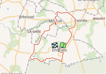
Tour Wandern von 16,1 km verfügbar auf Bretagne, Ille-et-Vilaine, Drouges. Diese Tour wird von COUROUSBERNARD vorgeschlagen.
Beschreibung
Circuit au départ de Drouges. circuit des braconniers N° 62 circuit des crêtes N°65 partiel et circuit pas des Romains N° 66 partiel. ( pique nique étang de Rannée )
Ort
Land:
France
Region :
Bretagne
Abteilung/Provinz :
Ille-et-Vilaine
Kommune :
Drouges
Standort:
Unknown
Gehen Sie:(Dec)
Gehen Sie:(UTM)
629628 ; 5306632 (30T) N.
Kommentare
Touren in der Umgebung
![Tour Wandern Rannée - Rannée circuit n°2 16 km - Photo](https://media.geolcdn.com/t/375/260/ext.jpg?maxdim=2&url=https%3A%2F%2Fstatic1.geolcdn.com%2Fsiteimages%2Fupload%2Ffiles%2F1553511878bg_sport_marche.png)
![Wandern Wandern](https://static1.geolcdn.com/sitytour/trail-icons/101.png)
Rannée circuit n°2 16 km
Wandern
Schwierig
Rannée,
Bretagne,
Ille-et-Vilaine,
France
![](/images/other/stat-length.png)
16 km | 17,4 km-effort
3h 57min
![](https://static1.geolcdn.com/siteimages/upload/files/16400158638029165_repeat_loop_refresh_sync_direction_icon.png)
Ja
![Tour Wandern Rannée - Rannée circuit n°1 18km - Photo](https://media.geolcdn.com/t/375/260/ext.jpg?maxdim=2&url=https%3A%2F%2Fstatic1.geolcdn.com%2Fsiteimages%2Fupload%2Ffiles%2F1553511878bg_sport_marche.png)
![Wandern Wandern](https://static1.geolcdn.com/sitytour/trail-icons/101.png)
Rannée circuit n°1 18km
Wandern
Sehr schwierig
Rannée,
Bretagne,
Ille-et-Vilaine,
France
![](/images/other/stat-length.png)
17,7 km | 19,5 km-effort
4h 25min
![](https://static1.geolcdn.com/siteimages/upload/files/16400158638029165_repeat_loop_refresh_sync_direction_icon.png)
Ja
![Tour Andere Aktivitäten Moussé - moussé - Photo](https://media.geolcdn.com/t/375/260/ext.jpg?maxdim=2&url=https%3A%2F%2Fstatic1.geolcdn.com%2Fsiteimages%2Fupload%2Ffiles%2F1545311037marcheuse_200dpi.jpg)
![Andere Aktivitäten Andere Aktivitäten](https://static1.geolcdn.com/sitytour/trail-icons/900.png)
moussé
Andere Aktivitäten
Sehr leicht
Moussé,
Bretagne,
Ille-et-Vilaine,
France
![](/images/other/stat-length.png)
8,2 km | 9,2 km-effort
2h 28min
![](https://static1.geolcdn.com/siteimages/upload/files/16400158638029165_repeat_loop_refresh_sync_direction_icon.png)
Ja
![Tour Wandern La Guerche-de-Bretagne - La Guerche-de-Bretagne / Pouencé - Photo](https://media.geolcdn.com/t/375/260/ext.jpg?maxdim=2&url=https%3A%2F%2Fstatic1.geolcdn.com%2Fsiteimages%2Fupload%2Ffiles%2F1553511878bg_sport_marche.png)
![Wandern Wandern](https://static1.geolcdn.com/sitytour/trail-icons/101.png)
La Guerche-de-Bretagne / Pouencé
Wandern
Einfach
La Guerche-de-Bretagne,
Bretagne,
Ille-et-Vilaine,
France
![](/images/other/stat-length.png)
31 km | 35 km-effort
Unbekannt
![](https://static1.geolcdn.com/siteimages/upload/files/16400158638029165_repeat_loop_refresh_sync_direction_icon.png)
Nein
![Tour Wandern Arbrissel - Arbrissel 02/11/24 - Photo](https://media.geolcdn.com/t/375/260/ext.jpg?maxdim=2&url=https%3A%2F%2Fstatic1.geolcdn.com%2Fsiteimages%2Fupload%2Ffiles%2F1553511878bg_sport_marche.png)
![Wandern Wandern](https://static1.geolcdn.com/sitytour/trail-icons/101.png)
Arbrissel 02/11/24
Wandern
Schwierig
Arbrissel,
Bretagne,
Ille-et-Vilaine,
France
![](/images/other/stat-length.png)
11 km | 12,1 km-effort
2h 56min
![](https://static1.geolcdn.com/siteimages/upload/files/16400158638029165_repeat_loop_refresh_sync_direction_icon.png)
Ja
![Tour Wandern Drouges - drouges après-midi - Photo](https://media.geolcdn.com/t/375/260/ext.jpg?maxdim=2&url=https%3A%2F%2Fstatic1.geolcdn.com%2Fsiteimages%2Fupload%2Ffiles%2F1553511878bg_sport_marche.png)
![Wandern Wandern](https://static1.geolcdn.com/sitytour/trail-icons/101.png)
drouges après-midi
Wandern
Medium
Drouges,
Bretagne,
Ille-et-Vilaine,
France
![](/images/other/stat-length.png)
6,8 km | 7,8 km-effort
1h 41min
![](https://static1.geolcdn.com/siteimages/upload/files/16400158638029165_repeat_loop_refresh_sync_direction_icon.png)
Ja
![Tour Wandern La Guerche-de-Bretagne - la guerche de Bretagne 19/11/23 - Photo](https://media.geolcdn.com/t/375/260/ext.jpg?maxdim=2&url=https%3A%2F%2Fstatic1.geolcdn.com%2Fsiteimages%2Fupload%2Ffiles%2F1553511878bg_sport_marche.png)
![Wandern Wandern](https://static1.geolcdn.com/sitytour/trail-icons/101.png)
la guerche de Bretagne 19/11/23
Wandern
Schwierig
La Guerche-de-Bretagne,
Bretagne,
Ille-et-Vilaine,
France
![](/images/other/stat-length.png)
11,8 km | 13,3 km-effort
3h 6min
![](https://static1.geolcdn.com/siteimages/upload/files/16400158638029165_repeat_loop_refresh_sync_direction_icon.png)
Ja
![Tour Wandern La Guerche-de-Bretagne - la guerche 04/11/2023 - Photo](https://media.geolcdn.com/t/375/260/ext.jpg?maxdim=2&url=https%3A%2F%2Fstatic1.geolcdn.com%2Fsiteimages%2Fupload%2Ffiles%2F1553511878bg_sport_marche.png)
![Wandern Wandern](https://static1.geolcdn.com/sitytour/trail-icons/101.png)
la guerche 04/11/2023
Wandern
Schwierig
La Guerche-de-Bretagne,
Bretagne,
Ille-et-Vilaine,
France
![](/images/other/stat-length.png)
13,4 km | 14,9 km-effort
3h 20min
![](https://static1.geolcdn.com/siteimages/upload/files/16400158638029165_repeat_loop_refresh_sync_direction_icon.png)
Ja
![Tour Wandern Drouges - DROUGES / MOUSSE / RANNEE 10/09/2023 - Photo](https://media.geolcdn.com/t/375/260/ext.jpg?maxdim=2&url=https%3A%2F%2Fstatic1.geolcdn.com%2Fsiteimages%2Fupload%2Ffiles%2F1553511878bg_sport_marche.png)
![Wandern Wandern](https://static1.geolcdn.com/sitytour/trail-icons/101.png)
DROUGES / MOUSSE / RANNEE 10/09/2023
Wandern
Sehr schwierig
Drouges,
Bretagne,
Ille-et-Vilaine,
France
![](/images/other/stat-length.png)
17,3 km | 19,7 km-effort
4h 28min
![](https://static1.geolcdn.com/siteimages/upload/files/16400158638029165_repeat_loop_refresh_sync_direction_icon.png)
Ja