![](/images/other/stat-length.png)
![Tour Wandern Abetone Cutigliano - Pian-di-Novello - Poggione - Uccelliera - Poggio degli Agli - Photo](https://media.geolcdn.com/t/1900/400/51a0eee2-5779-415d-9319-e60ea25f5e65.jpg&format=pjpeg&maxdim=2)
Pian-di-Novello - Poggione - Uccelliera - Poggio degli Agli
Elis Barbieri - Crb
Benutzer
![Länge](/images/other/stat-length.png)
![Maximale Höhe](https://static1.geolcdn.com/siteimages/upload/files/1508320355ic_sort_altitude_max_24dp.png)
![Positive Höhendifferenz](https://static1.geolcdn.com/siteimages/upload/files/1508320355ic_sort_den_pos_24dp.png)
![Km-Effort](/images/other/stat-length.png)
![Min. Höhe](https://static1.geolcdn.com/siteimages/upload/files/1508320355ic_sort_altitude_min_24dp.png)
![Negative Höhendifferenz](https://static1.geolcdn.com/siteimages/upload/files/1508320355ic_sort_den_neg_24dp.png)
![Boucle](https://static1.geolcdn.com/siteimages/upload/files/16400158638029165_repeat_loop_refresh_sync_direction_icon.png)
![Wandern](https://static1.geolcdn.com/sitytour/trail-icons/101.png)
6h32
Schwierigkeit : Medium
![Scannen Sie diesen QR-Code, um die Tour in der SityTrail-Anwendung zu öffnen](https://capi.geolives.com/qq0zvz2zws4bq2lad0pu/sitytour/trails/3794048/qr.png?size=200)
Kostenlosegpshiking-Anwendung
Über SityTrail
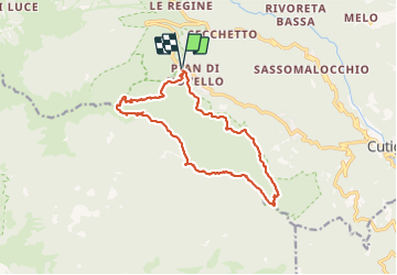
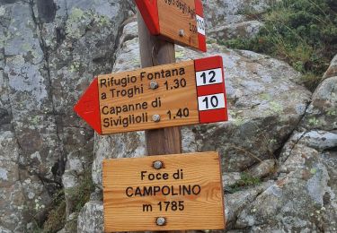
Tour Wandern von 15,3 km verfügbar auf Toskana, Pistoia, Abetone Cutigliano. Diese Tour wird von Elis Barbieri - Crb vorgeschlagen.
Beschreibung
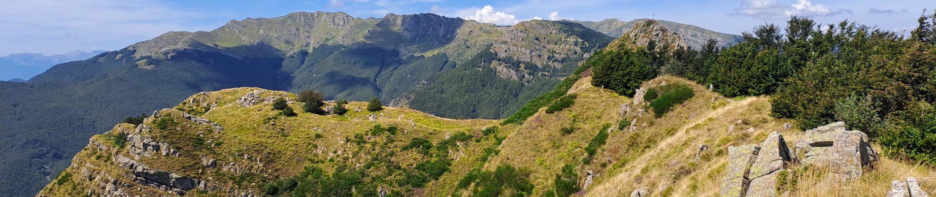
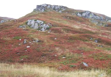
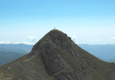
Rando très diversifiée en trois parties, l'ascension initiale assez sportive avec des pourcentages importants puis le long sentier de crête avec beaucoup de passages en sentier caché par la végétation : bruyères, fougères, framboisiers, joncs, etc. (pantalons longs indispensables...) et enfin le retour par un large chemin forestier facile qui revient en pente douce vers Pian-di-Novello.
Ort
Kommentare
Touren in der Umgebung
![Tour Zu Fuß Abetone Cutigliano - IT-507 - Photo](https://media.geolcdn.com/t/375/260/b0e1bc75-1c50-479c-ada2-a5db2babd61b.jpeg&format=jpg&maxdim=2)
![Zu Fuß Zu Fuß](https://static1.geolcdn.com/sitytour/trail-icons/100.png)
Zu Fuß
![](/images/other/stat-length.png)
![](https://static1.geolcdn.com/siteimages/upload/files/16400158638029165_repeat_loop_refresh_sync_direction_icon.png)
![Tour Zu Fuß Abetone Cutigliano - (SI L15) Abetone (Boscolungo) - Lago Santo Modenese - Photo](https://media.geolcdn.com/t/375/260/d9c856e7-0fee-46cb-b1dc-d250ecd0b74b.jpeg&format=jpg&maxdim=2)
![Zu Fuß Zu Fuß](https://static1.geolcdn.com/sitytour/trail-icons/100.png)
Zu Fuß
![](/images/other/stat-length.png)
![](https://static1.geolcdn.com/siteimages/upload/files/16400158638029165_repeat_loop_refresh_sync_direction_icon.png)
![Tour Zu Fuß Abetone Cutigliano - IT-100 - Photo](https://media.geolcdn.com/t/375/260/555a5dd0-53d5-431c-8b7e-814ca8ca46c4.jpeg&format=jpg&maxdim=2)
![Zu Fuß Zu Fuß](https://static1.geolcdn.com/sitytour/trail-icons/100.png)
Zu Fuß
![](/images/other/stat-length.png)
![](https://static1.geolcdn.com/siteimages/upload/files/16400158638029165_repeat_loop_refresh_sync_direction_icon.png)
![Tour Zu Fuß Abetone Cutigliano - Sentiero del Tedesco - Photo](https://media.geolcdn.com/t/375/260/ab8c7a67-de8b-49bd-88d7-f633522fd8d7.jpeg&format=jpg&maxdim=2)
![Zu Fuß Zu Fuß](https://static1.geolcdn.com/sitytour/trail-icons/100.png)
Zu Fuß
![](/images/other/stat-length.png)
![](https://static1.geolcdn.com/siteimages/upload/files/16400158638029165_repeat_loop_refresh_sync_direction_icon.png)
![Tour Zu Fuß Abetone Cutigliano - 102 - Photo](https://media.geolcdn.com/t/375/260/555a5dd0-53d5-431c-8b7e-814ca8ca46c4.jpeg&format=jpg&maxdim=2)
![Zu Fuß Zu Fuß](https://static1.geolcdn.com/sitytour/trail-icons/100.png)
![Tour Zu Fuß Fiumalbo - IT-435 - Photo](https://media.geolcdn.com/t/375/260/129dad30-8654-4316-99b2-cfd55f57a1c1.jpeg&format=jpg&maxdim=2)
![Zu Fuß Zu Fuß](https://static1.geolcdn.com/sitytour/trail-icons/100.png)
![Tour Zu Fuß Abetone Cutigliano - IT-08 - Photo](https://media.geolcdn.com/t/375/260/129dad30-8654-4316-99b2-cfd55f57a1c1.jpeg&format=jpg&maxdim=2)
![Zu Fuß Zu Fuß](https://static1.geolcdn.com/sitytour/trail-icons/100.png)
Zu Fuß
![](/images/other/stat-length.png)
![](https://static1.geolcdn.com/siteimages/upload/files/16400158638029165_repeat_loop_refresh_sync_direction_icon.png)
![Tour Zu Fuß Abetone Cutigliano - IT-519 - Photo](https://media.geolcdn.com/t/375/260/d9c856e7-0fee-46cb-b1dc-d250ecd0b74b.jpeg&format=jpg&maxdim=2)
![Zu Fuß Zu Fuß](https://static1.geolcdn.com/sitytour/trail-icons/100.png)
Zu Fuß
![](/images/other/stat-length.png)
![](https://static1.geolcdn.com/siteimages/upload/files/16400158638029165_repeat_loop_refresh_sync_direction_icon.png)
![Tour Wandern Abetone Cutigliano - Boucle du mont Poggione par le Lago Nero et le jardin botanique - Photo](https://media.geolcdn.com/t/375/260/c03edddb-8f6b-4b68-ad79-8797560634fd.jpg&format=jpg&maxdim=2)
![Wandern Wandern](https://static1.geolcdn.com/sitytour/trail-icons/101.png)
Wandern
![](/images/other/stat-length.png)
![](https://static1.geolcdn.com/siteimages/upload/files/16400158638029165_repeat_loop_refresh_sync_direction_icon.png)