![](/images/other/stat-length.png)
![Tour Wandern Estavar - Estavar - Sant-Vicenç- Estavar - Photo](https://media.geolcdn.com/t/1900/400/ext.pjpeg?maxdim=2&url=https%3A%2F%2Fstatic1.geolcdn.com%2Fsiteimages%2Fupload%2Ffiles%2F1553511878bg_sport_marche.png)
Estavar - Sant-Vicenç- Estavar
rene091957
Benutzer
![Länge](/images/other/stat-length.png)
Länge
12,1 km
![Maximale Höhe](https://static1.geolcdn.com/siteimages/upload/files/1508320355ic_sort_altitude_max_24dp.png)
Maximale Höhe
1515 m
![Positive Höhendifferenz](https://static1.geolcdn.com/siteimages/upload/files/1508320355ic_sort_den_pos_24dp.png)
Positive Höhendifferenz
398 m
![Km-Effort](/images/other/stat-length.png)
Km-Effort
17,4 km
![Min. Höhe](https://static1.geolcdn.com/siteimages/upload/files/1508320355ic_sort_altitude_min_24dp.png)
Min. Höhe
1221 m
![Negative Höhendifferenz](https://static1.geolcdn.com/siteimages/upload/files/1508320355ic_sort_den_neg_24dp.png)
Negative Höhendifferenz
399 m
![Boucle](https://static1.geolcdn.com/siteimages/upload/files/16400158638029165_repeat_loop_refresh_sync_direction_icon.png)
Boucle
Ja
Erstellungsdatum :
2023-09-03 14:55:23.679
Letzte Änderung :
2023-09-03 15:14:18.26
![Wandern](https://static1.geolcdn.com/sitytour/trail-icons/101.png)
3h57
Schwierigkeit : Schwierig
![Scannen Sie diesen QR-Code, um die Tour in der SityTrail-Anwendung zu öffnen](https://capi.geolives.com/qq0zvz2zws4bq2lad0pu/sitytour/trails/3793966/qr.png?size=200)
Kostenlosegpshiking-Anwendung
Über SityTrail
Tour Wandern von 12,1 km verfügbar auf Okzitanien, Ostpyrenäen, Estavar. Diese Tour wird von rene091957 vorgeschlagen.
Beschreibung
Estavar, Bajande, corniche Rec de Bajande, Sant Vicenç de Portoles, descente sur Bajande, Estavar.
Ort
Land:
France
Region :
Okzitanien
Abteilung/Provinz :
Ostpyrenäen
Kommune :
Estavar
Standort:
Unknown
Gehen Sie:(Dec)
Gehen Sie:(UTM)
417631 ; 4702219 (31T) N.
Kommentare
Touren in der Umgebung
![Tour Wandern Nahuja - boucle de Nahuja - Photo](https://media.geolcdn.com/t/375/260/ext.jpg?maxdim=2&url=https%3A%2F%2Fservices.sitytrail.com%2FGeolivesWS%2FDownloadMedia.ashx%3FTrailID%3D558835%26Media%3D20160425135530.jpg)
![Wandern Wandern](https://static1.geolcdn.com/sitytour/trail-icons/101.png)
boucle de Nahuja
Wandern
Medium
(1)
Nahuja,
Okzitanien,
Ostpyrenäen,
France
![](/images/other/stat-length.png)
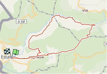
11,8 km | 18,2 km-effort
2h 44min
![](https://static1.geolcdn.com/siteimages/upload/files/16400158638029165_repeat_loop_refresh_sync_direction_icon.png)
Ja
![Tour Schneeschuhwandern Font-Romeu-Odeillo-Via - pic dels moros - Photo](https://media.geolcdn.com/t/375/260/ext.jpg?maxdim=2&url=https%3A%2F%2Fservices.sitytrail.com%2FGeolivesWS%2FDownloadMedia.ashx%3FTrailID%3D509986%26Media%3Dfix__20140323122816.jpg)
![Schneeschuhwandern Schneeschuhwandern](https://static1.geolcdn.com/sitytour/trail-icons/504.png)
pic dels moros
Schneeschuhwandern
Medium
(1)
Font-Romeu-Odeillo-Via,
Okzitanien,
Ostpyrenäen,
France
![](/images/other/stat-length.png)
12,6 km | 19,4 km-effort
4h 46min
![](https://static1.geolcdn.com/siteimages/upload/files/16400158638029165_repeat_loop_refresh_sync_direction_icon.png)
Ja
![Tour Wandern Font-Romeu-Odeillo-Via - Font Romeu Egat - Photo](https://media.geolcdn.com/t/375/260/ext.jpg?maxdim=2&url=https%3A%2F%2Fservices.sitytrail.com%2FGeolivesWS%2FDownloadMedia.ashx%3FTrailID%3D555215%26Media%3D20160418074519.jpg)
![Wandern Wandern](https://static1.geolcdn.com/sitytour/trail-icons/101.png)
Font Romeu Egat
Wandern
Medium
(2)
Font-Romeu-Odeillo-Via,
Okzitanien,
Ostpyrenäen,
France
![](/images/other/stat-length.png)
2,5 km | 3,4 km-effort
44min
![](https://static1.geolcdn.com/siteimages/upload/files/16400158638029165_repeat_loop_refresh_sync_direction_icon.png)
Ja
![Tour Schneeschuhwandern Font-Romeu-Odeillo-Via - Pic dels Moros avec Pierre - Photo](https://media.geolcdn.com/t/375/260/ext.jpg?maxdim=2&url=https%3A%2F%2Fservices.sitytrail.com%2FGeolivesWS%2FDownloadMedia.ashx%3FTrailID%3D542171%26Media%3Dfix__20160322124727.jpg)
![Schneeschuhwandern Schneeschuhwandern](https://static1.geolcdn.com/sitytour/trail-icons/504.png)
Pic dels Moros avec Pierre
Schneeschuhwandern
Medium
(1)
Font-Romeu-Odeillo-Via,
Okzitanien,
Ostpyrenäen,
France
![](/images/other/stat-length.png)
10,5 km | 15,9 km-effort
4h 4min
![](https://static1.geolcdn.com/siteimages/upload/files/16400158638029165_repeat_loop_refresh_sync_direction_icon.png)
Ja
![Tour Wandern Égat - Egat Puig Moro - Photo](https://media.geolcdn.com/t/375/260/ext.jpg?maxdim=2&url=https%3A%2F%2Fservices.sitytrail.com%2FGeolivesWS%2FDownloadMedia.ashx%3FTrailID%3D460362%26Media%3Dfix__20150817141649.jpg)
![Wandern Wandern](https://static1.geolcdn.com/sitytour/trail-icons/101.png)
Egat Puig Moro
Wandern
Medium
(1)
Égat,
Okzitanien,
Ostpyrenäen,
France
![](/images/other/stat-length.png)
13,4 km | 19,3 km-effort
4h 51min
![](https://static1.geolcdn.com/siteimages/upload/files/16400158638029165_repeat_loop_refresh_sync_direction_icon.png)
Ja
![Tour Wandern Égat - La croix d'Egat - Photo](https://media.geolcdn.com/t/375/260/ext.jpg?maxdim=2&url=https%3A%2F%2Fservices.sitytrail.com%2FGeolivesWS%2FDownloadMedia.ashx%3FTrailID%3D143230%26Media%3D20120803102022.jpeg)
![Wandern Wandern](https://static1.geolcdn.com/sitytour/trail-icons/101.png)
La croix d'Egat
Wandern
Einfach
(1)
Égat,
Okzitanien,
Ostpyrenäen,
France
![](/images/other/stat-length.png)
7,1 km | 10,4 km-effort
2h 2min
![](https://static1.geolcdn.com/siteimages/upload/files/16400158638029165_repeat_loop_refresh_sync_direction_icon.png)
Ja
![Tour Wandern Égat - Le Pic dels Moros - Photo](https://media.geolcdn.com/t/375/260/ext.jpg?maxdim=2&url=https%3A%2F%2Fservices.sitytrail.com%2FGeolivesWS%2FDownloadMedia.ashx%3FTrailID%3D108942%26Media%3D2804_1.jpg)
![Wandern Wandern](https://static1.geolcdn.com/sitytour/trail-icons/101.png)
Le Pic dels Moros
Wandern
Schwierig
(2)
Égat,
Okzitanien,
Ostpyrenäen,
France
![](/images/other/stat-length.png)
12,1 km | 18,8 km-effort
5h 30min
![](https://static1.geolcdn.com/siteimages/upload/files/16400158638029165_repeat_loop_refresh_sync_direction_icon.png)
Ja
![Tour Mountainbike Font-Romeu-Odeillo-Via - Espace VTT FFC Pyrénées Catalanes - Circuit n° 6 - Forêt d'Egat - Photo](https://media.geolcdn.com/t/375/260/ext.jpg?maxdim=2&url=https%3A%2F%2Fservices.sitytrail.com%2FGeolivesWS%2FDownloadMedia.ashx%3FTrailID%3D102104%26Media%3D2487_1.jpg)
![Mountainbike Mountainbike](https://static1.geolcdn.com/sitytour/trail-icons/202.png)
Espace VTT FFC Pyrénées Catalanes - Circuit n° 6 - Forêt d'Egat
Mountainbike
Medium
(2)
Font-Romeu-Odeillo-Via,
Okzitanien,
Ostpyrenäen,
France
![](/images/other/stat-length.png)
7,6 km | 10,1 km-effort
1h 0min
![](https://static1.geolcdn.com/siteimages/upload/files/16400158638029165_repeat_loop_refresh_sync_direction_icon.png)
Ja
![Tour sport Saillagouse - 20240623 Saillagouse -Err - Photo](https://media.geolcdn.com/t/375/260/d03d78d9-6da5-4117-90c7-02839286e5c6.jpg&format=jpg&maxdim=2)
20240623 Saillagouse -Err
sport
Sehr leicht
Saillagouse,
Okzitanien,
Ostpyrenäen,
France
![](/images/other/stat-length.png)
11,9 km | 15,5 km-effort
Unbekannt
![](https://static1.geolcdn.com/siteimages/upload/files/16400158638029165_repeat_loop_refresh_sync_direction_icon.png)
Ja