![](/images/other/stat-length.png)
![Tour Mountainbike Gien - De Gien à Isdes par GR3C Gien-Chambord Étape 1/3 - Photo](https://media.geolcdn.com/t/1900/400/ext.pjpeg?maxdim=2&url=https%3A%2F%2Fstatic1.geolcdn.com%2Fsiteimages%2Fupload%2Ffiles%2F1524743154velo.jpg)
De Gien à Isdes par GR3C Gien-Chambord Étape 1/3
dhommee
Benutzer
![Länge](/images/other/stat-length.png)
Länge
55 km
![Maximale Höhe](https://static1.geolcdn.com/siteimages/upload/files/1508320355ic_sort_altitude_max_24dp.png)
Maximale Höhe
181 m
![Positive Höhendifferenz](https://static1.geolcdn.com/siteimages/upload/files/1508320355ic_sort_den_pos_24dp.png)
Positive Höhendifferenz
422 m
![Km-Effort](/images/other/stat-length.png)
Km-Effort
61 km
![Min. Höhe](https://static1.geolcdn.com/siteimages/upload/files/1508320355ic_sort_altitude_min_24dp.png)
Min. Höhe
116 m
![Negative Höhendifferenz](https://static1.geolcdn.com/siteimages/upload/files/1508320355ic_sort_den_neg_24dp.png)
Negative Höhendifferenz
390 m
![Boucle](https://static1.geolcdn.com/siteimages/upload/files/16400158638029165_repeat_loop_refresh_sync_direction_icon.png)
Boucle
Nein
Erstellungsdatum :
2023-09-02 07:03:39.952
Letzte Änderung :
2023-09-02 16:51:21.884
![Mountainbike](https://static1.geolcdn.com/sitytour/trail-icons/202.png)
2h43
Schwierigkeit : Schwierig
![Scannen Sie diesen QR-Code, um die Tour in der SityTrail-Anwendung zu öffnen](https://capi.geolives.com/qq0zvz2zws4bq2lad0pu/sitytour/trails/3792349/qr.png?size=200)
Kostenlosegpshiking-Anwendung
Über SityTrail
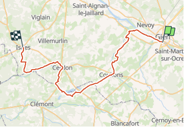
Tour Mountainbike von 55 km verfügbar auf Zentrum-Loiretal, Loiret, Gien. Diese Tour wird von dhommee vorgeschlagen.
Beschreibung
Chemins roulants pour la plupart. Quelques passage sur petites routes. Un peu d'herbes, un peu de sable pour faire travailler les muscles. Pas de chemin technique.
Ort
Land:
France
Region :
Zentrum-Loiretal
Abteilung/Provinz :
Loiret
Kommune :
Gien
Standort:
Unknown
Gehen Sie:(Dec)
Gehen Sie:(UTM)
472256 ; 5280922 (31T) N.
Kommentare
Touren in der Umgebung
![Tour Wandern Gien - gien Paulette - Photo](https://media.geolcdn.com/t/375/260/534c7fa9-f307-420f-a95d-291da4c7b928.jpg&format=jpg&maxdim=2)
![Wandern Wandern](https://static1.geolcdn.com/sitytour/trail-icons/101.png)
gien Paulette
Wandern
Schwierig
Gien,
Zentrum-Loiretal,
Loiret,
France
![](/images/other/stat-length.png)
14,4 km | 16,5 km-effort
3h 31min
![](https://static1.geolcdn.com/siteimages/upload/files/16400158638029165_repeat_loop_refresh_sync_direction_icon.png)
Nein
![Tour Wandern Gien - Gien à briare 45 - Photo](https://media.geolcdn.com/t/375/260/4dafb5ab-7682-4a42-b7b5-0fa4d7d55205.jpg&format=jpg&maxdim=2)
![Wandern Wandern](https://static1.geolcdn.com/sitytour/trail-icons/101.png)
Gien à briare 45
Wandern
Medium
Gien,
Zentrum-Loiretal,
Loiret,
France
![](/images/other/stat-length.png)
13,2 km | 14,9 km-effort
3h 4min
![](https://static1.geolcdn.com/siteimages/upload/files/16400158638029165_repeat_loop_refresh_sync_direction_icon.png)
Nein
![Tour Wandern Gien - Gien - Photo](https://media.geolcdn.com/t/375/260/ext.jpg?maxdim=2&url=https%3A%2F%2Fstatic1.geolcdn.com%2Fsiteimages%2Fupload%2Ffiles%2F1553511878bg_sport_marche.png)
![Wandern Wandern](https://static1.geolcdn.com/sitytour/trail-icons/101.png)
![Tour Rennrad Poilly-lez-Gien - j5 - Photo](https://media.geolcdn.com/t/375/260/ext.jpg?maxdim=2&url=https%3A%2F%2Fstatic1.geolcdn.com%2Fsiteimages%2Fupload%2Ffiles%2F1524743154velo.jpg)
![Rennrad Rennrad](https://static1.geolcdn.com/sitytour/trail-icons/201.png)
j5
Rennrad
Sehr schwierig
Poilly-lez-Gien,
Zentrum-Loiretal,
Loiret,
France
![](/images/other/stat-length.png)
59 km | 65 km-effort
3h 30min
![](https://static1.geolcdn.com/siteimages/upload/files/16400158638029165_repeat_loop_refresh_sync_direction_icon.png)
Nein
![Tour Wandern Poilly-lez-Gien - gr3 - Photo](https://media.geolcdn.com/t/375/260/ext.jpg?maxdim=2&url=https%3A%2F%2Fstatic1.geolcdn.com%2Fsiteimages%2Fupload%2Ffiles%2F1553511878bg_sport_marche.png)
![Wandern Wandern](https://static1.geolcdn.com/sitytour/trail-icons/101.png)
gr3
Wandern
Schwierig
Poilly-lez-Gien,
Zentrum-Loiretal,
Loiret,
France
![](/images/other/stat-length.png)
14,3 km | 15,8 km-effort
5h 58min
![](https://static1.geolcdn.com/siteimages/upload/files/16400158638029165_repeat_loop_refresh_sync_direction_icon.png)
Nein
![Tour Wandern Saint-Martin-sur-Ocre - St Martin sur Ocre - Photo](https://media.geolcdn.com/t/375/260/ext.jpg?maxdim=2&url=https%3A%2F%2Fstatic1.geolcdn.com%2Fsiteimages%2Fupload%2Ffiles%2F1553511878bg_sport_marche.png)
![Wandern Wandern](https://static1.geolcdn.com/sitytour/trail-icons/101.png)
St Martin sur Ocre
Wandern
Medium
Saint-Martin-sur-Ocre,
Zentrum-Loiretal,
Loiret,
France
![](/images/other/stat-length.png)
9,7 km | 10,6 km-effort
2h 32min
![](https://static1.geolcdn.com/siteimages/upload/files/16400158638029165_repeat_loop_refresh_sync_direction_icon.png)
Ja
![Tour Wandern Nevoy - Nevoy - Photo](https://media.geolcdn.com/t/375/260/ext.jpg?maxdim=2&url=https%3A%2F%2Fstatic1.geolcdn.com%2Fsiteimages%2Fupload%2Ffiles%2F1553511878bg_sport_marche.png)
![Wandern Wandern](https://static1.geolcdn.com/sitytour/trail-icons/101.png)
![Tour Zu Fuß Poilly-lez-Gien - Poilly-Lez-Gien 45 9km7 - Photo](https://media.geolcdn.com/t/375/260/ext.jpg?maxdim=2&url=https%3A%2F%2Fstatic1.geolcdn.com%2Fsiteimages%2Fupload%2Ffiles%2F1545311037marcheuse_200dpi.jpg)
![Zu Fuß Zu Fuß](https://static1.geolcdn.com/sitytour/trail-icons/100.png)
Poilly-Lez-Gien 45 9km7
Zu Fuß
Einfach
Poilly-lez-Gien,
Zentrum-Loiretal,
Loiret,
France
![](/images/other/stat-length.png)
9,7 km | 11 km-effort
Unbekannt
![](https://static1.geolcdn.com/siteimages/upload/files/16400158638029165_repeat_loop_refresh_sync_direction_icon.png)
Ja
![Tour Wandern Saint-Martin-sur-Ocre - St Martin sur ocre - Photo](https://media.geolcdn.com/t/375/260/ext.jpg?maxdim=2&url=https%3A%2F%2Fstatic1.geolcdn.com%2Fsiteimages%2Fupload%2Ffiles%2F1553511878bg_sport_marche.png)
![Wandern Wandern](https://static1.geolcdn.com/sitytour/trail-icons/101.png)
St Martin sur ocre
Wandern
Einfach
Saint-Martin-sur-Ocre,
Zentrum-Loiretal,
Loiret,
France
![](/images/other/stat-length.png)
10,9 km | 12,1 km-effort
3h 26min
![](https://static1.geolcdn.com/siteimages/upload/files/16400158638029165_repeat_loop_refresh_sync_direction_icon.png)
Ja