![](/images/other/stat-length.png)
![Tour Wandern Delincourt - Delincourt, Reilly, Latainville, Chambors, Delincourt - Photo](https://media.geolcdn.com/t/1900/400/ext.pjpeg?maxdim=2&url=https%3A%2F%2Fstatic1.geolcdn.com%2Fsiteimages%2Fupload%2Ffiles%2F1553511878bg_sport_marche.png)
Delincourt, Reilly, Latainville, Chambors, Delincourt
Marie-Claire-mcp
Benutzer
![Länge](/images/other/stat-length.png)
Länge
11,2 km
![Maximale Höhe](https://static1.geolcdn.com/siteimages/upload/files/1508320355ic_sort_altitude_max_24dp.png)
Maximale Höhe
144 m
![Positive Höhendifferenz](https://static1.geolcdn.com/siteimages/upload/files/1508320355ic_sort_den_pos_24dp.png)
Positive Höhendifferenz
213 m
![Km-Effort](/images/other/stat-length.png)
Km-Effort
14 km
![Min. Höhe](https://static1.geolcdn.com/siteimages/upload/files/1508320355ic_sort_altitude_min_24dp.png)
Min. Höhe
60 m
![Negative Höhendifferenz](https://static1.geolcdn.com/siteimages/upload/files/1508320355ic_sort_den_neg_24dp.png)
Negative Höhendifferenz
211 m
![Boucle](https://static1.geolcdn.com/siteimages/upload/files/16400158638029165_repeat_loop_refresh_sync_direction_icon.png)
Boucle
Ja
Erstellungsdatum :
2015-01-19 00:00:00.0
Letzte Änderung :
2015-01-19 00:00:00.0
![Wandern](https://static1.geolcdn.com/sitytour/trail-icons/101.png)
2h30
Schwierigkeit : Medium
![Scannen Sie diesen QR-Code, um die Tour in der SityTrail-Anwendung zu öffnen](https://capi.geolives.com/qq0zvz2zws4bq2lad0pu/sitytour/trails/378602/qr.png?size=200)
Kostenlosegpshiking-Anwendung
Über SityTrail
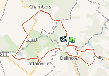
Tour Wandern von 11,2 km verfügbar auf Nordfrankreich, Oise, Delincourt. Diese Tour wird von Marie-Claire-mcp vorgeschlagen.
Beschreibung
Départ Mairie de Delincourt, rue du Mesnil, puis chemin à droite, Reilly, puis à droite et chemin de la vierge, cimetière de Delincourt puis Lattainville, puis Chambors et par le bois du dessus Delincourt
Ort
Land:
France
Region :
Nordfrankreich
Abteilung/Provinz :
Oise
Kommune :
Delincourt
Standort:
Unknown
Gehen Sie:(Dec)
Gehen Sie:(UTM)
414895 ; 5455587 (31U) N.
Kommentare
Touren in der Umgebung
![Tour Wandern Delincourt - Delincourt, Le Mesnil, Reilly, La vierge, Delincourt - Photo](https://media.geolcdn.com/t/375/260/e0951489-e018-4b39-a4ca-54d29c362145.jpg&format=jpg&maxdim=2)
![Wandern Wandern](https://static1.geolcdn.com/sitytour/trail-icons/101.png)
Delincourt, Le Mesnil, Reilly, La vierge, Delincourt
Wandern
Medium
(1)
Delincourt,
Nordfrankreich,
Oise,
France
![](/images/other/stat-length.png)
8,7 km | 10,4 km-effort
2h 16min
![](https://static1.geolcdn.com/siteimages/upload/files/16400158638029165_repeat_loop_refresh_sync_direction_icon.png)
Ja
![Tour Wandern Chambors - CHAMBORS - Lattainville-Delincourt-Reillly - Photo](https://media.geolcdn.com/t/375/260/ext.jpg?maxdim=2&url=https%3A%2F%2Fstatic1.geolcdn.com%2Fsiteimages%2Fupload%2Ffiles%2F1553511878bg_sport_marche.png)
![Wandern Wandern](https://static1.geolcdn.com/sitytour/trail-icons/101.png)
CHAMBORS - Lattainville-Delincourt-Reillly
Wandern
Sehr leicht
(1)
Chambors,
Nordfrankreich,
Oise,
France
![](/images/other/stat-length.png)
12,3 km | 15,2 km-effort
2h 54min
![](https://static1.geolcdn.com/siteimages/upload/files/16400158638029165_repeat_loop_refresh_sync_direction_icon.png)
Ja
![Tour Nordic Walking Chambors - Marche Nordique 61 Chambors - Photo](https://media.geolcdn.com/t/375/260/ext.jpg?maxdim=2&url=https%3A%2F%2Fstatic1.geolcdn.com%2Fsiteimages%2Fupload%2Ffiles%2F1545311037marcheuse_200dpi.jpg)
![Nordic Walking Nordic Walking](https://static1.geolcdn.com/sitytour/trail-icons/102.png)
Marche Nordique 61 Chambors
Nordic Walking
Einfach
(1)
Chambors,
Nordfrankreich,
Oise,
France
![](/images/other/stat-length.png)
8,4 km | 10,3 km-effort
1h 30min
![](https://static1.geolcdn.com/siteimages/upload/files/16400158638029165_repeat_loop_refresh_sync_direction_icon.png)
Ja
![Tour Wandern Trie-Château - Trie Château - La vallée de l'Aunette - Photo](https://media.geolcdn.com/t/375/260/ext.jpg?maxdim=2&url=https%3A%2F%2Fstatic1.geolcdn.com%2Fsiteimages%2Fupload%2Ffiles%2F1553511878bg_sport_marche.png)
![Wandern Wandern](https://static1.geolcdn.com/sitytour/trail-icons/101.png)
Trie Château - La vallée de l'Aunette
Wandern
Schwierig
(1)
Trie-Château,
Nordfrankreich,
Oise,
France
![](/images/other/stat-length.png)
11,8 km | 13,7 km-effort
3h 0min
![](https://static1.geolcdn.com/siteimages/upload/files/16400158638029165_repeat_loop_refresh_sync_direction_icon.png)
Ja
![Tour Wandern Montjavoult - Montjavoult - Vaudancourt - Photo](https://media.geolcdn.com/t/375/260/ext.jpg?maxdim=2&url=https%3A%2F%2Fstatic1.geolcdn.com%2Fsiteimages%2Fupload%2Ffiles%2F1553511878bg_sport_marche.png)
![Wandern Wandern](https://static1.geolcdn.com/sitytour/trail-icons/101.png)
Montjavoult - Vaudancourt
Wandern
Einfach
(1)
Montjavoult,
Nordfrankreich,
Oise,
France
![](/images/other/stat-length.png)
10,2 km | 12,2 km-effort
2h 39min
![](https://static1.geolcdn.com/siteimages/upload/files/16400158638029165_repeat_loop_refresh_sync_direction_icon.png)
Ja
![Tour Wandern Chambors - Chambors - le dolmen 12 - Photo](https://media.geolcdn.com/t/375/260/ext.jpg?maxdim=2&url=https%3A%2F%2Fstatic1.geolcdn.com%2Fsiteimages%2Fupload%2Ffiles%2F1553511878bg_sport_marche.png)
![Wandern Wandern](https://static1.geolcdn.com/sitytour/trail-icons/101.png)
Chambors - le dolmen 12
Wandern
Einfach
(1)
Chambors,
Nordfrankreich,
Oise,
France
![](/images/other/stat-length.png)
12,4 km | 16 km-effort
3h 31min
![](https://static1.geolcdn.com/siteimages/upload/files/16400158638029165_repeat_loop_refresh_sync_direction_icon.png)
Ja
![Tour Wandern Chambors - Chambors - le dolmen 9 - Photo](https://media.geolcdn.com/t/375/260/ext.jpg?maxdim=2&url=https%3A%2F%2Fstatic1.geolcdn.com%2Fsiteimages%2Fupload%2Ffiles%2F1553511878bg_sport_marche.png)
![Wandern Wandern](https://static1.geolcdn.com/sitytour/trail-icons/101.png)
Chambors - le dolmen 9
Wandern
Einfach
(4)
Chambors,
Nordfrankreich,
Oise,
France
![](/images/other/stat-length.png)
9,3 km | 12,1 km-effort
2h 38min
![](https://static1.geolcdn.com/siteimages/upload/files/16400158638029165_repeat_loop_refresh_sync_direction_icon.png)
Ja
![Tour Wandern Gisors - gisors champêtre et historique - Photo](https://media.geolcdn.com/t/375/260/578633a8-4c05-457b-921d-405112e7b824.jpg&format=jpg&maxdim=2)
![Wandern Wandern](https://static1.geolcdn.com/sitytour/trail-icons/101.png)
gisors champêtre et historique
Wandern
Schwierig
Gisors,
Normandie,
Eure,
France
![](/images/other/stat-length.png)
12,1 km | 13,6 km-effort
2h 13min
![](https://static1.geolcdn.com/siteimages/upload/files/16400158638029165_repeat_loop_refresh_sync_direction_icon.png)
Ja
![Tour Wandern Montjavoult - Montjavoult le gibet Valécourt - Photo](https://media.geolcdn.com/t/375/260/2cb6e3f0-fdc2-4bbc-af55-043b8b032a0d.jpg&format=jpg&maxdim=2)
![Wandern Wandern](https://static1.geolcdn.com/sitytour/trail-icons/101.png)
Montjavoult le gibet Valécourt
Wandern
Schwierig
Montjavoult,
Nordfrankreich,
Oise,
France
![](/images/other/stat-length.png)
12,8 km | 15,4 km-effort
2h 19min
![](https://static1.geolcdn.com/siteimages/upload/files/16400158638029165_repeat_loop_refresh_sync_direction_icon.png)
Ja