![](/images/other/stat-length.png)
![Tour Wandern Montfermeil - GRP CV-IDF 11R Montfermeil à Chelles - Photo](https://media.geolcdn.com/t/1900/400/5eb6e624-b5d8-403c-9227-5ad3885fc26c.jpg&format=pjpeg&maxdim=2)
GRP CV-IDF 11R Montfermeil à Chelles
clalaur
Benutzer
![Länge](/images/other/stat-length.png)
Länge
10,3 km
![Maximale Höhe](https://static1.geolcdn.com/siteimages/upload/files/1508320355ic_sort_altitude_max_24dp.png)
Maximale Höhe
115 m
![Positive Höhendifferenz](https://static1.geolcdn.com/siteimages/upload/files/1508320355ic_sort_den_pos_24dp.png)
Positive Höhendifferenz
106 m
![Km-Effort](/images/other/stat-length.png)
Km-Effort
11,9 km
![Min. Höhe](https://static1.geolcdn.com/siteimages/upload/files/1508320355ic_sort_altitude_min_24dp.png)
Min. Höhe
38 m
![Negative Höhendifferenz](https://static1.geolcdn.com/siteimages/upload/files/1508320355ic_sort_den_neg_24dp.png)
Negative Höhendifferenz
179 m
![Boucle](https://static1.geolcdn.com/siteimages/upload/files/16400158638029165_repeat_loop_refresh_sync_direction_icon.png)
Boucle
Nein
Erstellungsdatum :
2023-08-27 09:10:49.382
Letzte Änderung :
2024-01-21 10:48:40.149
![Wandern](https://static1.geolcdn.com/sitytour/trail-icons/101.png)
2h42
Schwierigkeit : Medium
![Scannen Sie diesen QR-Code, um die Tour in der SityTrail-Anwendung zu öffnen](https://capi.geolives.com/qq0zvz2zws4bq2lad0pu/sitytour/trails/3785794/qr.png?size=200)
Kostenlosegpshiking-Anwendung
Über SityTrail
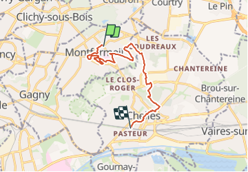
Tour Wandern von 10,3 km verfügbar auf Île-de-France, Seine-Saint-Denis, Montfermeil. Diese Tour wird von clalaur vorgeschlagen.
Beschreibung
Randonnée faite le 12 janvier 2024 dans l'après-midi.
Départ : Hôpital de Montfermeil (Tram T4) Montfermeil ; Arrivée : Chelles - Gournay (RER E ; Train P) Chelles
Ort
Land:
France
Region :
Île-de-France
Abteilung/Provinz :
Seine-Saint-Denis
Kommune :
Montfermeil
Standort:
Unknown
Gehen Sie:(Dec)
Gehen Sie:(UTM)
468546 ; 5416544 (31U) N.
Kommentare
Touren in der Umgebung
![Tour Wandern Chelles - GRP CV-IDF 06 - Photo](https://media.geolcdn.com/t/375/260/3e851a57-05bf-470c-9490-37cd07bf40e9.jpg&format=jpg&maxdim=2)
![Wandern Wandern](https://static1.geolcdn.com/sitytour/trail-icons/101.png)
GRP CV-IDF 06
Wandern
Medium
(1)
Chelles,
Île-de-France,
Seine-et-Marne,
France
![](/images/other/stat-length.png)
15 km | 16,7 km-effort
3h 47min
![](https://static1.geolcdn.com/siteimages/upload/files/16400158638029165_repeat_loop_refresh_sync_direction_icon.png)
Nein
![Tour Wandern Gournay-sur-Marne - Boucle Gournay/ Marne - Noisy le Grand - Champs sur Marne - Photo](https://media.geolcdn.com/t/375/260/89921577-96fb-496f-92ce-fb28ab23f5a4.jpg&format=jpg&maxdim=2)
![Wandern Wandern](https://static1.geolcdn.com/sitytour/trail-icons/101.png)
Boucle Gournay/ Marne - Noisy le Grand - Champs sur Marne
Wandern
Sehr leicht
Gournay-sur-Marne,
Île-de-France,
Seine-Saint-Denis,
France
![](/images/other/stat-length.png)
20 km | 23 km-effort
4h 41min
![](https://static1.geolcdn.com/siteimages/upload/files/16400158638029165_repeat_loop_refresh_sync_direction_icon.png)
Ja
![Tour Wandern Noisiel - Noisiel Grand parcours - Photo](https://media.geolcdn.com/t/375/260/ext.jpg?maxdim=2&url=https%3A%2F%2Fstatic1.geolcdn.com%2Fsiteimages%2Fupload%2Ffiles%2F1553511878bg_sport_marche.png)
![Wandern Wandern](https://static1.geolcdn.com/sitytour/trail-icons/101.png)
Noisiel Grand parcours
Wandern
Einfach
(1)
Noisiel,
Île-de-France,
Seine-et-Marne,
France
![](/images/other/stat-length.png)
21 km | 23 km-effort
4h 50min
![](https://static1.geolcdn.com/siteimages/upload/files/16400158638029165_repeat_loop_refresh_sync_direction_icon.png)
Ja
![Tour Zu Fuß Gournay-sur-Marne - PR des Bords de Marne - Photo](https://media.geolcdn.com/t/375/260/35af0a4c-48e1-4bf2-9200-6ffba4c50b2f.jpeg&format=jpg&maxdim=2)
![Zu Fuß Zu Fuß](https://static1.geolcdn.com/sitytour/trail-icons/100.png)
PR des Bords de Marne
Zu Fuß
Einfach
Gournay-sur-Marne,
Île-de-France,
Seine-Saint-Denis,
France
![](/images/other/stat-length.png)
7,3 km | 8 km-effort
1h 48min
![](https://static1.geolcdn.com/siteimages/upload/files/16400158638029165_repeat_loop_refresh_sync_direction_icon.png)
Nein
![Tour Wandern Chelles - Chelles_Montfermeil_Chelles-11039915-1628508469-77 - Photo](https://media.geolcdn.com/t/375/260/ext.jpg?maxdim=2&url=https%3A%2F%2Fstatic1.geolcdn.com%2Fsiteimages%2Fupload%2Ffiles%2F1553511878bg_sport_marche.png)
![Wandern Wandern](https://static1.geolcdn.com/sitytour/trail-icons/101.png)
Chelles_Montfermeil_Chelles-11039915-1628508469-77
Wandern
Sehr schwierig
(1)
Chelles,
Île-de-France,
Seine-et-Marne,
France
![](/images/other/stat-length.png)
17,5 km | 21 km-effort
4h 44min
![](https://static1.geolcdn.com/siteimages/upload/files/16400158638029165_repeat_loop_refresh_sync_direction_icon.png)
Ja
![Tour Wandern Sevran - 10671022-FORET DE BONDY - Photo](https://media.geolcdn.com/t/375/260/ext.jpg?maxdim=2&url=https%3A%2F%2Fstatic1.geolcdn.com%2Fsiteimages%2Fupload%2Ffiles%2F1553511878bg_sport_marche.png)
![Wandern Wandern](https://static1.geolcdn.com/sitytour/trail-icons/101.png)
10671022-FORET DE BONDY
Wandern
Sehr schwierig
(1)
Sevran,
Île-de-France,
Seine-Saint-Denis,
France
![](/images/other/stat-length.png)
16,4 km | 19,3 km-effort
4h 22min
![](https://static1.geolcdn.com/siteimages/upload/files/16400158638029165_repeat_loop_refresh_sync_direction_icon.png)
Nein
![Tour Wandern Sevran - SEVRAN > MITRY 17 KM - Photo](https://media.geolcdn.com/t/375/260/ext.jpg?maxdim=2&url=https%3A%2F%2Fstatic1.geolcdn.com%2Fsiteimages%2Fupload%2Ffiles%2F1553511878bg_sport_marche.png)
![Wandern Wandern](https://static1.geolcdn.com/sitytour/trail-icons/101.png)
SEVRAN > MITRY 17 KM
Wandern
Einfach
(1)
Sevran,
Île-de-France,
Seine-Saint-Denis,
France
![](/images/other/stat-length.png)
16,4 km | 17,9 km-effort
40min
![](https://static1.geolcdn.com/siteimages/upload/files/16400158638029165_repeat_loop_refresh_sync_direction_icon.png)
Nein
![Tour Wandern Sevran - SityTrail - GRP CV-IDF - Photo](https://media.geolcdn.com/t/375/260/18441606-1eb8-4ce4-9102-146617f13bed.jpg&format=jpg&maxdim=2)
![Wandern Wandern](https://static1.geolcdn.com/sitytour/trail-icons/101.png)
SityTrail - GRP CV-IDF
Wandern
Medium
Sevran,
Île-de-France,
Seine-Saint-Denis,
France
![](/images/other/stat-length.png)
17,9 km | 19,7 km-effort
4h 30min
![](https://static1.geolcdn.com/siteimages/upload/files/16400158638029165_repeat_loop_refresh_sync_direction_icon.png)
Nein
![Tour Wandern Chelles - SityTrail - GRP CV-IDF - Photo](https://media.geolcdn.com/t/375/260/1a91b0c8-12d6-449b-baf1-7e52147f06ef.jpg&format=jpg&maxdim=2)
![Wandern Wandern](https://static1.geolcdn.com/sitytour/trail-icons/101.png)
SityTrail - GRP CV-IDF
Wandern
Medium
Chelles,
Île-de-France,
Seine-et-Marne,
France
![](/images/other/stat-length.png)
20 km | 24 km-effort
5h 45min
![](https://static1.geolcdn.com/siteimages/upload/files/16400158638029165_repeat_loop_refresh_sync_direction_icon.png)
Nein