![](/images/other/stat-length.png)
![Tour Wandern Sevran - GRP CV-IDF 2023 - Photo](https://media.geolcdn.com/t/1900/400/950950b2-9364-4198-942f-a4494e346704.jpg&format=pjpeg&maxdim=2)
GRP CV-IDF 2023
clalaur
Benutzer
![Länge](/images/other/stat-length.png)
Länge
12,9 km
![Maximale Höhe](https://static1.geolcdn.com/siteimages/upload/files/1508320355ic_sort_altitude_max_24dp.png)
Maximale Höhe
129 m
![Positive Höhendifferenz](https://static1.geolcdn.com/siteimages/upload/files/1508320355ic_sort_den_pos_24dp.png)
Positive Höhendifferenz
157 m
![Km-Effort](/images/other/stat-length.png)
Km-Effort
14,8 km
![Min. Höhe](https://static1.geolcdn.com/siteimages/upload/files/1508320355ic_sort_altitude_min_24dp.png)
Min. Höhe
55 m
![Negative Höhendifferenz](https://static1.geolcdn.com/siteimages/upload/files/1508320355ic_sort_den_neg_24dp.png)
Negative Höhendifferenz
101 m
![Boucle](https://static1.geolcdn.com/siteimages/upload/files/16400158638029165_repeat_loop_refresh_sync_direction_icon.png)
Boucle
Nein
Erstellungsdatum :
2023-08-27 08:13:08.254
Letzte Änderung :
2024-01-21 10:18:07.111
![Wandern](https://static1.geolcdn.com/sitytour/trail-icons/101.png)
3h22
Schwierigkeit : Medium
![Scannen Sie diesen QR-Code, um die Tour in der SityTrail-Anwendung zu öffnen](https://capi.geolives.com/qq0zvz2zws4bq2lad0pu/sitytour/trails/3785724/qr.png?size=200)
Kostenlosegpshiking-Anwendung
Über SityTrail
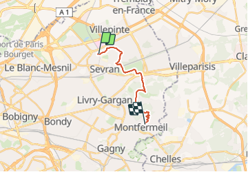
Tour Wandern von 12,9 km verfügbar auf Île-de-France, Seine-Saint-Denis, Sevran. Diese Tour wird von clalaur vorgeschlagen.
Beschreibung
Randonnée faite le 12 janvier 2004 le matin.
Départ : Gare Sevran-Beaudottes (RER B) Sevran ; Arrivée : Hôpital de Montfermeil (Bus 613) Montfermeil
Ort
Land:
France
Region :
Île-de-France
Abteilung/Provinz :
Seine-Saint-Denis
Kommune :
Sevran
Standort:
Unknown
Gehen Sie:(Dec)
Gehen Sie:(UTM)
465187 ; 5421707 (31U) N.
Kommentare
Touren in der Umgebung
![Tour Wandern Sevran - 10671022-FORET DE BONDY - Photo](https://media.geolcdn.com/t/375/260/ext.jpg?maxdim=2&url=https%3A%2F%2Fstatic1.geolcdn.com%2Fsiteimages%2Fupload%2Ffiles%2F1553511878bg_sport_marche.png)
![Wandern Wandern](https://static1.geolcdn.com/sitytour/trail-icons/101.png)
10671022-FORET DE BONDY
Wandern
Sehr schwierig
(1)
Sevran,
Île-de-France,
Seine-Saint-Denis,
France
![](/images/other/stat-length.png)
16,4 km | 19,3 km-effort
4h 22min
![](https://static1.geolcdn.com/siteimages/upload/files/16400158638029165_repeat_loop_refresh_sync_direction_icon.png)
Nein
![Tour Wandern Sevran - SEVRAN > MITRY 17 KM - Photo](https://media.geolcdn.com/t/375/260/ext.jpg?maxdim=2&url=https%3A%2F%2Fstatic1.geolcdn.com%2Fsiteimages%2Fupload%2Ffiles%2F1553511878bg_sport_marche.png)
![Wandern Wandern](https://static1.geolcdn.com/sitytour/trail-icons/101.png)
SEVRAN > MITRY 17 KM
Wandern
Einfach
(1)
Sevran,
Île-de-France,
Seine-Saint-Denis,
France
![](/images/other/stat-length.png)
16,4 km | 17,9 km-effort
40min
![](https://static1.geolcdn.com/siteimages/upload/files/16400158638029165_repeat_loop_refresh_sync_direction_icon.png)
Nein
![Tour Wandern Sevran - SityTrail - GRP CV-IDF - Photo](https://media.geolcdn.com/t/375/260/18441606-1eb8-4ce4-9102-146617f13bed.jpg&format=jpg&maxdim=2)
![Wandern Wandern](https://static1.geolcdn.com/sitytour/trail-icons/101.png)
SityTrail - GRP CV-IDF
Wandern
Medium
Sevran,
Île-de-France,
Seine-Saint-Denis,
France
![](/images/other/stat-length.png)
17,9 km | 19,7 km-effort
4h 30min
![](https://static1.geolcdn.com/siteimages/upload/files/16400158638029165_repeat_loop_refresh_sync_direction_icon.png)
Nein
![Tour Andere Aktivitäten Coubron - autour de coubron - Photo](https://media.geolcdn.com/t/375/260/ext.jpg?maxdim=2&url=https%3A%2F%2Fstatic1.geolcdn.com%2Fsiteimages%2Fupload%2Ffiles%2F1545311037marcheuse_200dpi.jpg)
![Andere Aktivitäten Andere Aktivitäten](https://static1.geolcdn.com/sitytour/trail-icons/900.png)
autour de coubron
Andere Aktivitäten
Einfach
(1)
Coubron,
Île-de-France,
Seine-Saint-Denis,
France
![](/images/other/stat-length.png)
8,8 km | 10,4 km-effort
2h 16min
![](https://static1.geolcdn.com/siteimages/upload/files/16400158638029165_repeat_loop_refresh_sync_direction_icon.png)
Ja
![Tour Wandern Sevran - sevran - Photo](https://media.geolcdn.com/t/375/260/4adabccb-5fe9-404a-8b34-afb8df8dbc6b.jpg&format=jpg&maxdim=2)
![Wandern Wandern](https://static1.geolcdn.com/sitytour/trail-icons/101.png)
sevran
Wandern
Medium
Sevran,
Île-de-France,
Seine-Saint-Denis,
France
![](/images/other/stat-length.png)
6,1 km | 6,4 km-effort
1h 46min
![](https://static1.geolcdn.com/siteimages/upload/files/16400158638029165_repeat_loop_refresh_sync_direction_icon.png)
Ja
![Tour Wandern Les Pavillons-sous-Bois - balade - Photo](https://media.geolcdn.com/t/375/260/6b45e378-7c4b-4a7a-9c60-cbd336290f71.jpg&format=jpg&maxdim=2)
![Wandern Wandern](https://static1.geolcdn.com/sitytour/trail-icons/101.png)
balade
Wandern
Medium
Les Pavillons-sous-Bois,
Île-de-France,
Seine-Saint-Denis,
France
![](/images/other/stat-length.png)
8 km | 8,4 km-effort
1h 46min
![](https://static1.geolcdn.com/siteimages/upload/files/16400158638029165_repeat_loop_refresh_sync_direction_icon.png)
Ja
![Tour Wandern Clichy-sous-Bois - chevaux et dhyus - Photo](https://media.geolcdn.com/t/375/260/35c8b8d1-70bd-4357-b3b1-7676ad7b26ad.jpg&format=jpg&maxdim=2)
![Wandern Wandern](https://static1.geolcdn.com/sitytour/trail-icons/101.png)
chevaux et dhyus
Wandern
Medium
Clichy-sous-Bois,
Île-de-France,
Seine-Saint-Denis,
France
![](/images/other/stat-length.png)
6,8 km | 7,9 km-effort
1h 37min
![](https://static1.geolcdn.com/siteimages/upload/files/16400158638029165_repeat_loop_refresh_sync_direction_icon.png)
Nein
![Tour Wandern Coubron - Coteaux de l'Aulnoye - Photo](https://media.geolcdn.com/t/375/260/71ec1a59-2520-4102-8466-b3b0e980753d.jpg&format=jpg&maxdim=2)
![Wandern Wandern](https://static1.geolcdn.com/sitytour/trail-icons/101.png)
Coteaux de l'Aulnoye
Wandern
Sehr leicht
Coubron,
Île-de-France,
Seine-Saint-Denis,
France
![](/images/other/stat-length.png)
4,6 km | 5,5 km-effort
1h 10min
![](https://static1.geolcdn.com/siteimages/upload/files/16400158638029165_repeat_loop_refresh_sync_direction_icon.png)
Ja
![Tour Wandern Vaujours - Aqueduc de la Dhuis et retour par le canal de l'Ourq - Photo](https://media.geolcdn.com/t/375/260/ext.jpg?maxdim=2&url=https%3A%2F%2Fservices.sitytrail.com%2FGeolivesWS%2FDownloadMedia.ashx%3FTrailID%3D191340%26Media%3D14898_2.jpg)
![Wandern Wandern](https://static1.geolcdn.com/sitytour/trail-icons/101.png)
Aqueduc de la Dhuis et retour par le canal de l'Ourq
Wandern
Medium
Vaujours,
Île-de-France,
Seine-Saint-Denis,
France
![](/images/other/stat-length.png)
28 km | 31 km-effort
5h 0min
![](https://static1.geolcdn.com/siteimages/upload/files/16400158638029165_repeat_loop_refresh_sync_direction_icon.png)
Ja