![](/images/other/stat-length.png)
![Tour Wandern Laveissière - Balade à Lavaissiére - Photo](https://media.geolcdn.com/t/1900/400/290103a2-7d42-4bdd-a3ae-9f858a857d85.jpg&format=pjpeg&maxdim=2)
Balade à Lavaissiére
alainjoseph6
Benutzer
![Länge](/images/other/stat-length.png)
Länge
2,4 km
![Maximale Höhe](https://static1.geolcdn.com/siteimages/upload/files/1508320355ic_sort_altitude_max_24dp.png)
Maximale Höhe
946 m
![Positive Höhendifferenz](https://static1.geolcdn.com/siteimages/upload/files/1508320355ic_sort_den_pos_24dp.png)
Positive Höhendifferenz
34 m
![Km-Effort](/images/other/stat-length.png)
Km-Effort
2,8 km
![Min. Höhe](https://static1.geolcdn.com/siteimages/upload/files/1508320355ic_sort_altitude_min_24dp.png)
Min. Höhe
921 m
![Negative Höhendifferenz](https://static1.geolcdn.com/siteimages/upload/files/1508320355ic_sort_den_neg_24dp.png)
Negative Höhendifferenz
34 m
![Boucle](https://static1.geolcdn.com/siteimages/upload/files/16400158638029165_repeat_loop_refresh_sync_direction_icon.png)
Boucle
Ja
Erstellungsdatum :
2023-08-26 16:22:58.592
Letzte Änderung :
2023-08-26 17:26:31.593
![Wandern](https://static1.geolcdn.com/sitytour/trail-icons/101.png)
1h02
Schwierigkeit : Einfach
![Scannen Sie diesen QR-Code, um die Tour in der SityTrail-Anwendung zu öffnen](https://capi.geolives.com/qq0zvz2zws4bq2lad0pu/sitytour/trails/3785373/qr.png?size=200)
Kostenlosegpshiking-Anwendung
Über SityTrail
Tour Wandern von 2,4 km verfügbar auf Auvergne-Rhone-Alpen, Cantal, Laveissière. Diese Tour wird von alainjoseph6 vorgeschlagen.
Beschreibung
Une petite balade au départ du camping le Lavagnon en suivant le petit torrent vers le lac et retour par le village.
Ort
Land:
France
Region :
Auvergne-Rhone-Alpen
Abteilung/Provinz :
Cantal
Kommune :
Laveissière
Standort:
Unknown
Gehen Sie:(Dec)
Gehen Sie:(UTM)
485150 ; 4995852 (31T) N.
Kommentare
Touren in der Umgebung
![Tour Wandern Dienne - Cantal - le Chaumeil - Dienne et Rocher de Laqueille - 9km 265m 2h50 - 2019 07 05 - Photo](https://media.geolcdn.com/t/375/260/0c8731bc-bb27-41ed-bdb7-c3b60f017a8f.jpg&format=jpg&maxdim=2)
![Wandern Wandern](https://static1.geolcdn.com/sitytour/trail-icons/101.png)
Cantal - le Chaumeil - Dienne et Rocher de Laqueille - 9km 265m 2h50 - 2019 0...
Wandern
Sehr leicht
(1)
Dienne,
Auvergne-Rhone-Alpen,
Cantal,
France
![](/images/other/stat-length.png)
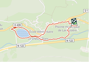
9 km | 12,6 km-effort
2h 50min
![](https://static1.geolcdn.com/siteimages/upload/files/16400158638029165_repeat_loop_refresh_sync_direction_icon.png)
Ja
![Tour Wandern Albepierre-Bredons - Cantal - Albepierre - les Cascades - 9.6km 330m 3h25 - 2019 06 23 - Photo](https://media.geolcdn.com/t/375/260/7c343e5b-9b79-4737-bf33-8f8bb008b3a2.jpg&format=jpg&maxdim=2)
![Wandern Wandern](https://static1.geolcdn.com/sitytour/trail-icons/101.png)
Cantal - Albepierre - les Cascades - 9.6km 330m 3h25 - 2019 06 23
Wandern
Einfach
(1)
Albepierre-Bredons,
Auvergne-Rhone-Alpen,
Cantal,
France
![](/images/other/stat-length.png)
9,6 km | 14,1 km-effort
3h 26min
![](https://static1.geolcdn.com/siteimages/upload/files/16400158638029165_repeat_loop_refresh_sync_direction_icon.png)
Ja
![Tour Wandern Murat - les estives et tourbière de Chastel sur Murat - Photo](https://media.geolcdn.com/t/375/260/177cc3c3-d770-480f-901b-cbeaabf71678.jpg&format=jpg&maxdim=2)
![Wandern Wandern](https://static1.geolcdn.com/sitytour/trail-icons/101.png)
les estives et tourbière de Chastel sur Murat
Wandern
Einfach
(1)
Murat,
Auvergne-Rhone-Alpen,
Cantal,
France
![](/images/other/stat-length.png)
7,7 km | 10,5 km-effort
2h 16min
![](https://static1.geolcdn.com/siteimages/upload/files/16400158638029165_repeat_loop_refresh_sync_direction_icon.png)
Ja
![Tour Wandern Laveissière - Le Puy Griou de Super Lioran - Photo](https://media.geolcdn.com/t/375/260/ext.jpg?maxdim=2&url=https%3A%2F%2Fservices.sitytrail.com%2FGeolivesWS%2FDownloadMedia.ashx%3FTrailID%3D105565%26Media%3D9330_5.jpg)
![Wandern Wandern](https://static1.geolcdn.com/sitytour/trail-icons/101.png)
Le Puy Griou de Super Lioran
Wandern
Medium
(2)
Laveissière,
Auvergne-Rhone-Alpen,
Cantal,
France
![](/images/other/stat-length.png)
11,9 km | 19,7 km-effort
5h 0min
![](https://static1.geolcdn.com/siteimages/upload/files/16400158638029165_repeat_loop_refresh_sync_direction_icon.png)
Ja
![Tour Wandern Laveissière - Le plomb du Cantal - Le Lioran - Photo](https://media.geolcdn.com/t/375/260/ext.jpg?maxdim=2&url=https%3A%2F%2Fservices.sitytrail.com%2FGeolivesWS%2FDownloadMedia.ashx%3FTrailID%3D105562%26Media%3D9325_5.jpg)
![Wandern Wandern](https://static1.geolcdn.com/sitytour/trail-icons/101.png)
Le plomb du Cantal - Le Lioran
Wandern
Medium
(1)
Laveissière,
Auvergne-Rhone-Alpen,
Cantal,
France
![](/images/other/stat-length.png)
14,4 km | 27 km-effort
6h 0min
![](https://static1.geolcdn.com/siteimages/upload/files/16400158638029165_repeat_loop_refresh_sync_direction_icon.png)
Ja
![Tour Wandern Laveissière - Le lac Glory de Laveissière - Photo](https://media.geolcdn.com/t/375/260/ext.jpg?maxdim=2&url=https%3A%2F%2Fservices.sitytrail.com%2FGeolivesWS%2FDownloadMedia.ashx%3FTrailID%3D106468%26Media%3D10983_1.jpg)
![Wandern Wandern](https://static1.geolcdn.com/sitytour/trail-icons/101.png)
Le lac Glory de Laveissière
Wandern
Medium
(2)
Laveissière,
Auvergne-Rhone-Alpen,
Cantal,
France
![](/images/other/stat-length.png)
11,1 km | 16,8 km-effort
4h 0min
![](https://static1.geolcdn.com/siteimages/upload/files/16400158638029165_repeat_loop_refresh_sync_direction_icon.png)
Ja
![Tour Rennrad Albepierre-Bredons - cascades de Veyrines et lac du pêcher - Photo](https://media.geolcdn.com/t/375/260/51bbe222-68fd-40c8-b03d-d522f834567b.jpg&format=jpg&maxdim=2)
![Rennrad Rennrad](https://static1.geolcdn.com/sitytour/trail-icons/201.png)
cascades de Veyrines et lac du pêcher
Rennrad
Medium
Albepierre-Bredons,
Auvergne-Rhone-Alpen,
Cantal,
France
![](/images/other/stat-length.png)
73 km | 90 km-effort
4h 12min
![](https://static1.geolcdn.com/siteimages/upload/files/16400158638029165_repeat_loop_refresh_sync_direction_icon.png)
Ja
![Tour Rennrad Albepierre-Bredons - Sanissage 5 cascades - Photo](https://media.geolcdn.com/t/375/260/85ecf86a-b278-4ee6-890b-5b284e817c7d.jpg&format=jpg&maxdim=2)
![Rennrad Rennrad](https://static1.geolcdn.com/sitytour/trail-icons/201.png)
Sanissage 5 cascades
Rennrad
Medium
Albepierre-Bredons,
Auvergne-Rhone-Alpen,
Cantal,
France
![](/images/other/stat-length.png)
19,3 km | 28 km-effort
1h 12min
![](https://static1.geolcdn.com/siteimages/upload/files/16400158638029165_repeat_loop_refresh_sync_direction_icon.png)
Nein
![Tour Rennrad Albepierre-Bredons - Le puy Mary par St Jacques des blats retour Dienne - Photo](https://media.geolcdn.com/t/375/260/27e4b2a9-b34d-4064-9ff2-6d8b9b60bab0.jpg&format=jpg&maxdim=2)
![Rennrad Rennrad](https://static1.geolcdn.com/sitytour/trail-icons/201.png)
Le puy Mary par St Jacques des blats retour Dienne
Rennrad
Schwierig
Albepierre-Bredons,
Auvergne-Rhone-Alpen,
Cantal,
France
![](/images/other/stat-length.png)
84 km | 115 km-effort
4h 7min
![](https://static1.geolcdn.com/siteimages/upload/files/16400158638029165_repeat_loop_refresh_sync_direction_icon.png)
Ja