![](/images/other/stat-length.png)
![Tour Wandern L'Étang-la-Ville - GRP CV-IDF 2023 - Photo](https://media.geolcdn.com/t/1900/400/5b76ffb0-032e-4c30-9eff-c534da0117fa.jpg&format=pjpeg&maxdim=2)
GRP CV-IDF 2023
clalaur
Benutzer
![Länge](/images/other/stat-length.png)
Länge
10,7 km
![Maximale Höhe](https://static1.geolcdn.com/siteimages/upload/files/1508320355ic_sort_altitude_max_24dp.png)
Maximale Höhe
182 m
![Positive Höhendifferenz](https://static1.geolcdn.com/siteimages/upload/files/1508320355ic_sort_den_pos_24dp.png)
Positive Höhendifferenz
198 m
![Km-Effort](/images/other/stat-length.png)
Km-Effort
13,7 km
![Min. Höhe](https://static1.geolcdn.com/siteimages/upload/files/1508320355ic_sort_altitude_min_24dp.png)
Min. Höhe
49 m
![Negative Höhendifferenz](https://static1.geolcdn.com/siteimages/upload/files/1508320355ic_sort_den_neg_24dp.png)
Negative Höhendifferenz
285 m
![Boucle](https://static1.geolcdn.com/siteimages/upload/files/16400158638029165_repeat_loop_refresh_sync_direction_icon.png)
Boucle
Nein
Erstellungsdatum :
2023-08-23 16:13:36.998
Letzte Änderung :
2023-09-19 10:02:35.696
![Wandern](https://static1.geolcdn.com/sitytour/trail-icons/101.png)
3h06
Schwierigkeit : Schwierig
![Scannen Sie diesen QR-Code, um die Tour in der SityTrail-Anwendung zu öffnen](https://capi.geolives.com/qq0zvz2zws4bq2lad0pu/sitytour/trails/3782365/qr.png?size=200)
Kostenlosegpshiking-Anwendung
Über SityTrail
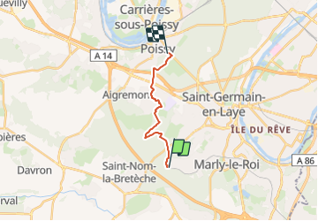
Tour Wandern von 10,7 km verfügbar auf Île-de-France, Yvelines, L'Étang-la-Ville. Diese Tour wird von clalaur vorgeschlagen.
Beschreibung
Randonnée faite le vendredi 15 septembre 2023 dans la matinée. Départ : Gare de Saint-Nom la Bretèche - Forêt de Marly (Train L) ; Arrivée : Arrêt Fernand Lefèbvre (BUS 1) Poissy
Ort
Land:
France
Region :
Île-de-France
Abteilung/Provinz :
Yvelines
Kommune :
L'Étang-la-Ville
Standort:
Unknown
Gehen Sie:(Dec)
Gehen Sie:(UTM)
430442 ; 5413048 (31U) N.
Kommentare
Touren in der Umgebung
![Tour Wandern Chambourcy - Ballade autour du golf de Chambourcy - Photo](https://media.geolcdn.com/t/375/260/ec912980-2058-4871-9f73-872617e204cc.jpg&format=jpg&maxdim=2)
![Wandern Wandern](https://static1.geolcdn.com/sitytour/trail-icons/101.png)
Ballade autour du golf de Chambourcy
Wandern
Medium
(1)
Chambourcy,
Île-de-France,
Yvelines,
France
![](/images/other/stat-length.png)
8,5 km | 10,6 km-effort
1h 55min
![](https://static1.geolcdn.com/siteimages/upload/files/16400158638029165_repeat_loop_refresh_sync_direction_icon.png)
Ja
![Tour Wandern Marly-le-Roi - Boucle 25 km Marly le Roi - Chambourcy - Photo](https://media.geolcdn.com/t/375/260/1fe661ec-cb67-45eb-bf71-8b90e4b33a5d.jpg&format=jpg&maxdim=2)
![Wandern Wandern](https://static1.geolcdn.com/sitytour/trail-icons/101.png)
Boucle 25 km Marly le Roi - Chambourcy
Wandern
Medium
Marly-le-Roi,
Île-de-France,
Yvelines,
France
![](/images/other/stat-length.png)
25 km | 32 km-effort
7h 15min
![](https://static1.geolcdn.com/siteimages/upload/files/16400158638029165_repeat_loop_refresh_sync_direction_icon.png)
Ja
![Tour Wandern Saint-Germain-en-Laye - Audax St Germain en Laye - Paris Tour Eiffel - Photo](https://media.geolcdn.com/t/375/260/5e15adf7-e627-4ac0-b5fd-8bf0b40406ac.jpg&format=jpg&maxdim=2)
![Wandern Wandern](https://static1.geolcdn.com/sitytour/trail-icons/101.png)
Audax St Germain en Laye - Paris Tour Eiffel
Wandern
Einfach
Saint-Germain-en-Laye,
Île-de-France,
Yvelines,
France
![](/images/other/stat-length.png)
29 km | 35 km-effort
4h 59min
![](https://static1.geolcdn.com/siteimages/upload/files/16400158638029165_repeat_loop_refresh_sync_direction_icon.png)
Nein
![Tour Wandern L'Étang-la-Ville - Gare de St Nom - Boucle nocturne Gr ~2h 8,5km - Photo](https://media.geolcdn.com/t/375/260/ext.jpg?maxdim=2&url=https%3A%2F%2Fstatic1.geolcdn.com%2Fsiteimages%2Fupload%2Ffiles%2F1553511878bg_sport_marche.png)
![Wandern Wandern](https://static1.geolcdn.com/sitytour/trail-icons/101.png)
Gare de St Nom - Boucle nocturne Gr ~2h 8,5km
Wandern
Einfach
(1)
L'Étang-la-Ville,
Île-de-France,
Yvelines,
France
![](/images/other/stat-length.png)
24 km | 28 km-effort
12h 14min
![](https://static1.geolcdn.com/siteimages/upload/files/16400158638029165_repeat_loop_refresh_sync_direction_icon.png)
Nein
![Tour Zu Fuß L'Étang-la-Ville - Le tour du Grand Paris par le GR1 Etape 2 - Saint Nom la Bretèche - Triel sur Seine - Photo](https://media.geolcdn.com/t/375/260/1683ad58-8376-4601-9416-cabd4c0df082.jpg&format=jpg&maxdim=2)
![Zu Fuß Zu Fuß](https://static1.geolcdn.com/sitytour/trail-icons/100.png)
Le tour du Grand Paris par le GR1 Etape 2 - Saint Nom la Bretèche - Triel sur...
Zu Fuß
Schwierig
L'Étang-la-Ville,
Île-de-France,
Yvelines,
France
![](/images/other/stat-length.png)
31 km | 36 km-effort
8h 16min
![](https://static1.geolcdn.com/siteimages/upload/files/16400158638029165_repeat_loop_refresh_sync_direction_icon.png)
Nein
![Tour Wandern Marly-le-Roi - 2025 02 05 Louveciennes 11 km - Photo](https://media.geolcdn.com/t/375/260/ext.jpg?maxdim=2&url=https%3A%2F%2Fstatic1.geolcdn.com%2Fsiteimages%2Fupload%2Ffiles%2F1553511878bg_sport_marche.png)
![Wandern Wandern](https://static1.geolcdn.com/sitytour/trail-icons/101.png)
2025 02 05 Louveciennes 11 km
Wandern
Einfach
(1)
Marly-le-Roi,
Île-de-France,
Yvelines,
France
![](/images/other/stat-length.png)
11,2 km | 14,2 km-effort
3h 13min
![](https://static1.geolcdn.com/siteimages/upload/files/16400158638029165_repeat_loop_refresh_sync_direction_icon.png)
Ja
![Wandern Wandern](https://static1.geolcdn.com/sitytour/trail-icons/101.png)
2024-11-12-Rennemoulin-fontaine de Maltoute
Wandern
Medium
Rennemoulin,
Île-de-France,
Yvelines,
France
![](/images/other/stat-length.png)
6,6 km | 7,8 km-effort
1h 47min
![](https://static1.geolcdn.com/siteimages/upload/files/16400158638029165_repeat_loop_refresh_sync_direction_icon.png)
Ja
![Tour Wandern Le Pecq - 20230707 RS - Photo](https://media.geolcdn.com/t/375/260/ext.jpg?maxdim=2&url=https%3A%2F%2Fstatic1.geolcdn.com%2Fsiteimages%2Fupload%2Ffiles%2F1553511878bg_sport_marche.png)
![Wandern Wandern](https://static1.geolcdn.com/sitytour/trail-icons/101.png)
20230707 RS
Wandern
Einfach
(1)
Le Pecq,
Île-de-France,
Yvelines,
France
![](/images/other/stat-length.png)
5 km | 5,8 km-effort
1h 19min
![](https://static1.geolcdn.com/siteimages/upload/files/16400158638029165_repeat_loop_refresh_sync_direction_icon.png)
Ja
![Tour Wandern Saint-Germain-en-Laye - Terrasse st germain - Photo](https://media.geolcdn.com/t/375/260/e6b7601a-fda4-43a7-b3a4-d2256a08c415.jpg&format=jpg&maxdim=2)
![Wandern Wandern](https://static1.geolcdn.com/sitytour/trail-icons/101.png)
Terrasse st germain
Wandern
Sehr leicht
Saint-Germain-en-Laye,
Île-de-France,
Yvelines,
France
![](/images/other/stat-length.png)
5,4 km | 6,1 km-effort
1h 27min
![](https://static1.geolcdn.com/siteimages/upload/files/16400158638029165_repeat_loop_refresh_sync_direction_icon.png)
Nein