![](/images/other/stat-length.png)
![Tour Wandern Sceaux - SCEAUX - Photo](https://media.geolcdn.com/t/1900/400/ext.pjpeg?maxdim=2&url=https%3A%2F%2Fstatic1.geolcdn.com%2Fsiteimages%2Fupload%2Ffiles%2F1553511878bg_sport_marche.png)
SCEAUX
Martial LHUILLERY
Benutzer
![Länge](/images/other/stat-length.png)
Länge
20 km
![Maximale Höhe](https://static1.geolcdn.com/siteimages/upload/files/1508320355ic_sort_altitude_max_24dp.png)
Maximale Höhe
182 m
![Positive Höhendifferenz](https://static1.geolcdn.com/siteimages/upload/files/1508320355ic_sort_den_pos_24dp.png)
Positive Höhendifferenz
280 m
![Km-Effort](/images/other/stat-length.png)
Km-Effort
24 km
![Min. Höhe](https://static1.geolcdn.com/siteimages/upload/files/1508320355ic_sort_altitude_min_24dp.png)
Min. Höhe
56 m
![Negative Höhendifferenz](https://static1.geolcdn.com/siteimages/upload/files/1508320355ic_sort_den_neg_24dp.png)
Negative Höhendifferenz
276 m
![Boucle](https://static1.geolcdn.com/siteimages/upload/files/16400158638029165_repeat_loop_refresh_sync_direction_icon.png)
Boucle
Ja
Erstellungsdatum :
2023-08-23 07:46:20.188
Letzte Änderung :
2023-08-23 16:31:07.272
![Wandern](https://static1.geolcdn.com/sitytour/trail-icons/101.png)
4h28
Schwierigkeit : Schwierig
![Scannen Sie diesen QR-Code, um die Tour in der SityTrail-Anwendung zu öffnen](https://capi.geolives.com/qq0zvz2zws4bq2lad0pu/sitytour/trails/3782168/qr.png?size=200)
Kostenlosegpshiking-Anwendung
Über SityTrail
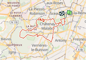
Tour Wandern von 20 km verfügbar auf Île-de-France, Hauts-de-Seine, Sceaux. Diese Tour wird von Martial LHUILLERY vorgeschlagen.
Beschreibung
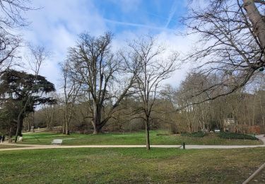
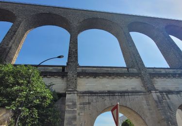
20km pour 280m , départ du Parc de Sceaux, rejoindre la Forêt de Verrières, puis traverser la cité jardin de la Butte rouge et le domaine de la Vallée aux Loups de Châtenay-Malabry, puis retour au Parc de Sceaux.
Ort
Land:
France
Region :
Île-de-France
Abteilung/Provinz :
Hauts-de-Seine
Kommune :
Sceaux
Standort:
Unknown
Gehen Sie:(Dec)
Gehen Sie:(UTM)
448803 ; 5402643 (31U) N.
Kommentare
Touren in der Umgebung
![Tour Wandern Verrières-le-Buisson - Sur les sentiers de découverte du Bois de Verrières - Photo](https://media.geolcdn.com/t/375/260/ext.jpg?maxdim=2&url=https%3A%2F%2Fservices.sitytrail.com%2FGeolivesWS%2FDownloadMedia.ashx%3FTrailID%3D110232%26Media%3D5500_1.jpg)
![Wandern Wandern](https://static1.geolcdn.com/sitytour/trail-icons/101.png)
Sur les sentiers de découverte du Bois de Verrières
Wandern
Medium
(2)
Verrières-le-Buisson,
Île-de-France,
Essonne,
France
![](/images/other/stat-length.png)
22 km | 27 km-effort
4h 40min
![](https://static1.geolcdn.com/siteimages/upload/files/16400158638029165_repeat_loop_refresh_sync_direction_icon.png)
Ja
![Tour Wandern Sceaux - Les Hauts de Bièvre - Photo](https://media.geolcdn.com/t/375/260/ext.jpg?maxdim=2&url=https%3A%2F%2Fservices.sitytrail.com%2FGeolivesWS%2FDownloadMedia.ashx%3FTrailID%3D110019%26Media%3D5127_1.jpg)
![Wandern Wandern](https://static1.geolcdn.com/sitytour/trail-icons/101.png)
Les Hauts de Bièvre
Wandern
Schwierig
(2)
Sceaux,
Île-de-France,
Hauts-de-Seine,
France
![](/images/other/stat-length.png)
25 km | 30 km-effort
6h 0min
![](https://static1.geolcdn.com/siteimages/upload/files/16400158638029165_repeat_loop_refresh_sync_direction_icon.png)
Ja
![Tour Wandern Fontenay-aux-Roses - Rando des 3 Parcs ! (des Gares RER) - Photo](https://media.geolcdn.com/t/375/260/ext.jpg?maxdim=2&url=https%3A%2F%2Fstatic1.geolcdn.com%2Fsiteimages%2Fupload%2Ffiles%2F1553511878bg_sport_marche.png)
![Wandern Wandern](https://static1.geolcdn.com/sitytour/trail-icons/101.png)
Rando des 3 Parcs ! (des Gares RER)
Wandern
Sehr schwierig
(2)
Fontenay-aux-Roses,
Île-de-France,
Hauts-de-Seine,
France
![](/images/other/stat-length.png)
15,9 km | 19,5 km-effort
4h 26min
![](https://static1.geolcdn.com/siteimages/upload/files/16400158638029165_repeat_loop_refresh_sync_direction_icon.png)
Nein
![Tour Zu Fuß Antony - Sur la Rive Gauche de la Bièvre - Photo](https://media.geolcdn.com/t/375/260/ext.jpg?maxdim=2&url=https%3A%2F%2Fmedia.geolcdn.com%2Ff%2F2c3929b8-0b44-4788-adde-07756b1afabd.jpeg)
![Zu Fuß Zu Fuß](https://static1.geolcdn.com/sitytour/trail-icons/100.png)
Sur la Rive Gauche de la Bièvre
Zu Fuß
Einfach
Antony,
Île-de-France,
Hauts-de-Seine,
France
![](/images/other/stat-length.png)
5 km | 6,2 km-effort
1h 24min
![](https://static1.geolcdn.com/siteimages/upload/files/16400158638029165_repeat_loop_refresh_sync_direction_icon.png)
Nein
![Tour Wandern Clamart - Tour des etangs - Bois de Clamart et de Meudon - Photo](https://media.geolcdn.com/t/375/260/ext.jpg?maxdim=2&url=https%3A%2F%2Fmedia.geolcdn.com%2Ff%2F95237daa-2f69-4622-acc2-897839c78a72.jpg)
![Wandern Wandern](https://static1.geolcdn.com/sitytour/trail-icons/101.png)
Tour des etangs - Bois de Clamart et de Meudon
Wandern
Einfach
Clamart,
Île-de-France,
Hauts-de-Seine,
France
![](/images/other/stat-length.png)
8 km | 9,9 km-effort
2h 16min
![](https://static1.geolcdn.com/siteimages/upload/files/16400158638029165_repeat_loop_refresh_sync_direction_icon.png)
Ja
![Tour Wandern Antony - De gare à gare - Photo](https://media.geolcdn.com/t/375/260/ext.jpg?maxdim=2&url=https%3A%2F%2Fstatic1.geolcdn.com%2Fsiteimages%2Fupload%2Ffiles%2F1553511878bg_sport_marche.png)
![Wandern Wandern](https://static1.geolcdn.com/sitytour/trail-icons/101.png)
De gare à gare
Wandern
Einfach
(1)
Antony,
Île-de-France,
Hauts-de-Seine,
France
![](/images/other/stat-length.png)
6,4 km | 7,2 km-effort
1h 29min
![](https://static1.geolcdn.com/siteimages/upload/files/16400158638029165_repeat_loop_refresh_sync_direction_icon.png)
Nein
![Tour Wandern Gentilly - BAGNEUX _ GENTILLY 5 KM - Photo](https://media.geolcdn.com/t/375/260/ext.jpg?maxdim=2&url=https%3A%2F%2Fstatic1.geolcdn.com%2Fsiteimages%2Fupload%2Ffiles%2F1553511878bg_sport_marche.png)
![Wandern Wandern](https://static1.geolcdn.com/sitytour/trail-icons/101.png)
BAGNEUX _ GENTILLY 5 KM
Wandern
Medium
(1)
Gentilly,
Île-de-France,
Val-de-Marne,
France
![](/images/other/stat-length.png)
5,3 km | 6,2 km-effort
1h 23min
![](https://static1.geolcdn.com/siteimages/upload/files/16400158638029165_repeat_loop_refresh_sync_direction_icon.png)
Nein
![Tour Wandern Sceaux - Sur les pas de Châteaubriant - Photo](https://media.geolcdn.com/t/375/260/ext.jpg?maxdim=2&url=https%3A%2F%2Fmedia.geolcdn.com%2Ff%2F6464ca19-73f5-4fbc-8f49-a3821d0ff0dc.jpg)
![Wandern Wandern](https://static1.geolcdn.com/sitytour/trail-icons/101.png)
Sur les pas de Châteaubriant
Wandern
Medium
Sceaux,
Île-de-France,
Hauts-de-Seine,
France
![](/images/other/stat-length.png)
16,7 km | 20 km-effort
4h 33min
![](https://static1.geolcdn.com/siteimages/upload/files/16400158638029165_repeat_loop_refresh_sync_direction_icon.png)
Ja
![Tour Wandern Bagneux - Chatillon - Photo](https://media.geolcdn.com/t/375/260/ext.jpg?maxdim=2&url=https%3A%2F%2Fmedia.geolcdn.com%2Ff%2Fca0c0ced-ef16-4ead-9352-c2531a0f1ae6.jpg)
![Wandern Wandern](https://static1.geolcdn.com/sitytour/trail-icons/101.png)
Chatillon
Wandern
Einfach
Bagneux,
Île-de-France,
Hauts-de-Seine,
France
![](/images/other/stat-length.png)
13,7 km | 16 km-effort
3h 31min
![](https://static1.geolcdn.com/siteimages/upload/files/16400158638029165_repeat_loop_refresh_sync_direction_icon.png)
Ja