![](/images/other/stat-length.png)
![Tour Mountainbike Vielsalm - Entre vallées du Rechter Bach et de l'Amblève - Photo](https://media.geolcdn.com/t/1900/400/ext.pjpeg?maxdim=2&url=https%3A%2F%2Fstatic1.geolcdn.com%2Fsiteimages%2Fupload%2Ffiles%2F1524743154velo.jpg)
Entre vallées du Rechter Bach et de l'Amblève
Nico222
Benutzer
![Länge](/images/other/stat-length.png)
Länge
36 km
![Maximale Höhe](https://static1.geolcdn.com/siteimages/upload/files/1508320355ic_sort_altitude_max_24dp.png)
Maximale Höhe
599 m
![Positive Höhendifferenz](https://static1.geolcdn.com/siteimages/upload/files/1508320355ic_sort_den_pos_24dp.png)
Positive Höhendifferenz
889 m
![Km-Effort](/images/other/stat-length.png)
Km-Effort
48 km
![Min. Höhe](https://static1.geolcdn.com/siteimages/upload/files/1508320355ic_sort_altitude_min_24dp.png)
Min. Höhe
341 m
![Negative Höhendifferenz](https://static1.geolcdn.com/siteimages/upload/files/1508320355ic_sort_den_neg_24dp.png)
Negative Höhendifferenz
883 m
![Boucle](https://static1.geolcdn.com/siteimages/upload/files/16400158638029165_repeat_loop_refresh_sync_direction_icon.png)
Boucle
Ja
Erstellungsdatum :
2015-01-22 00:00:00.0
Letzte Änderung :
2015-01-22 00:00:00.0
![Mountainbike](https://static1.geolcdn.com/sitytour/trail-icons/202.png)
3h03
Schwierigkeit : Medium
![Scannen Sie diesen QR-Code, um die Tour in der SityTrail-Anwendung zu öffnen](https://capi.geolives.com/qq0zvz2zws4bq2lad0pu/sitytour/trails/377796/qr.png?size=200)
Kostenlosegpshiking-Anwendung
Über SityTrail
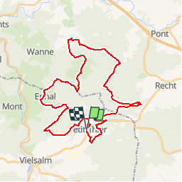
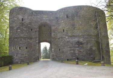
Tour Mountainbike von 36 km verfügbar auf Wallonien, Luxemburg, Vielsalm. Diese Tour wird von Nico222 vorgeschlagen.
Beschreibung
Rejoindre le guide au départ du parking de l'Eglise de Petit-Thier. Attention ce parcours peut être physique à certains endroits. Ne convient pas pour un public familiale.
Ort
Land:
Belgium
Region :
Wallonien
Abteilung/Provinz :
Luxemburg
Kommune :
Vielsalm
Standort:
Petit-Thier
Gehen Sie:(Dec)
Gehen Sie:(UTM)
711277 ; 5577022 (31U) N.
Kommentare
Touren in der Umgebung
![Tour Wandern Dreibrücken - Logbiermé. Natura 2000, des sites qui valent le détour ! Lg5 - Photo](https://media.geolcdn.com/t/375/260/ext.jpg?maxdim=2&url=https%3A%2F%2Fservices.sitytrail.com%2FGeolivesWS%2FDownloadMedia.ashx%3FTrailID%3D142605%26Media%3Db59446be-93ad-402a-bf6d-b5189e61bcf2.JPG)
![Wandern Wandern](https://static1.geolcdn.com/sitytour/trail-icons/101.png)
Logbiermé. Natura 2000, des sites qui valent le détour ! Lg5
Wandern
Einfach
(10)
Dreibrücken,
Wallonien,
Lüttich,
Belgium
![](/images/other/stat-length.png)
8,4 km | 10,9 km-effort
Unbekannt
![](https://static1.geolcdn.com/siteimages/upload/files/16400158638029165_repeat_loop_refresh_sync_direction_icon.png)
Ja
![Tour Wandern Vielsalm - 2023-04-02_15h38m24_Cirkwi-Vielsalm___Pays_du_bois,_de_la_pierre_de_l_eau - Photo](https://media.geolcdn.com/t/375/260/0c677089-4c6a-401e-ab95-09fc62ad11cf.jpg&format=jpg&maxdim=2)
![Wandern Wandern](https://static1.geolcdn.com/sitytour/trail-icons/101.png)
2023-04-02_15h38m24_Cirkwi-Vielsalm___Pays_du_bois,_de_la_pierre_de_l_eau
Wandern
Medium
(2)
Vielsalm,
Wallonien,
Luxemburg,
Belgium
![](/images/other/stat-length.png)
11,6 km | 15,6 km-effort
3h 32min
![](https://static1.geolcdn.com/siteimages/upload/files/16400158638029165_repeat_loop_refresh_sync_direction_icon.png)
Ja
![Tour Wandern Vielsalm - GG-Lu-16_Vielsalm - Gouvy - Photo](https://media.geolcdn.com/t/375/260/8dcabdae-2ff1-4908-b3bb-b5309e97313c.jpg&format=jpg&maxdim=2)
![Wandern Wandern](https://static1.geolcdn.com/sitytour/trail-icons/101.png)
GG-Lu-16_Vielsalm - Gouvy
Wandern
Sehr schwierig
(3)
Vielsalm,
Wallonien,
Luxemburg,
Belgium
![](/images/other/stat-length.png)
16 km | 22 km-effort
4h 48min
![](https://static1.geolcdn.com/siteimages/upload/files/16400158638029165_repeat_loop_refresh_sync_direction_icon.png)
Nein
![Tour Wandern Vielsalm - RB-LUX-03 - Raccourci - Dans les vallées de la Salm et du Glain - Photo](https://media.geolcdn.com/t/375/260/ext.jpg?maxdim=2&url=https%3A%2F%2Fservices.sitytrail.com%2FGeolivesWS%2FDownloadMedia.ashx%3FTrailID%3D216051%26Media%3D51a8d94d-ce85-4f46-8793-517bb65c5b20.jpg)
![Wandern Wandern](https://static1.geolcdn.com/sitytour/trail-icons/101.png)
RB-LUX-03 - Raccourci - Dans les vallées de la Salm et du Glain
Wandern
Einfach
(4)
Vielsalm,
Wallonien,
Luxemburg,
Belgium
![](/images/other/stat-length.png)
16,8 km | 23 km-effort
3h 36min
![](https://static1.geolcdn.com/siteimages/upload/files/16400158638029165_repeat_loop_refresh_sync_direction_icon.png)
Ja
![Tour Wandern Vielsalm - RB-LUX-03 - Dans les vallées de la Salm et du Glain - Photo](https://media.geolcdn.com/t/375/260/ext.jpg?maxdim=2&url=https%3A%2F%2Fservices.sitytrail.com%2FGeolivesWS%2FDownloadMedia.ashx%3FTrailID%3D179612%26Media%3Db9c1cda3-4257-4d22-9a9f-65f69e9d8092.jpg)
![Wandern Wandern](https://static1.geolcdn.com/sitytour/trail-icons/101.png)
RB-LUX-03 - Dans les vallées de la Salm et du Glain
Wandern
Medium
(4)
Vielsalm,
Wallonien,
Luxemburg,
Belgium
![](/images/other/stat-length.png)
22 km | 30 km-effort
6h 10min
![](https://static1.geolcdn.com/siteimages/upload/files/16400158638029165_repeat_loop_refresh_sync_direction_icon.png)
Ja
![Tour Wandern Vielsalm - Balade à Salmchateau - Photo](https://media.geolcdn.com/t/375/260/3de6bc27-49c3-4a0d-9844-4130c8ac5c83.jpeg&format=jpg&maxdim=2)
![Wandern Wandern](https://static1.geolcdn.com/sitytour/trail-icons/101.png)
Balade à Salmchateau
Wandern
Schwierig
Vielsalm,
Wallonien,
Luxemburg,
Belgium
![](/images/other/stat-length.png)
9,8 km | 13,4 km-effort
3h 2min
![](https://static1.geolcdn.com/siteimages/upload/files/16400158638029165_repeat_loop_refresh_sync_direction_icon.png)
Ja
![Tour Wandern Vielsalm - La nature en questions - Photo](https://media.geolcdn.com/t/375/260/c82c6954-3937-4349-a2df-80b6eaa40ce3.jpg&format=jpg&maxdim=2)
![Wandern Wandern](https://static1.geolcdn.com/sitytour/trail-icons/101.png)
La nature en questions
Wandern
Medium
Vielsalm,
Wallonien,
Luxemburg,
Belgium
![](/images/other/stat-length.png)
7 km | 9,8 km-effort
2h 13min
![](https://static1.geolcdn.com/siteimages/upload/files/16400158638029165_repeat_loop_refresh_sync_direction_icon.png)
Ja
![Tour Wandern Vielsalm - Forêt domaniale du Grand-Bois - Photo](https://media.geolcdn.com/t/375/260/fa7127a4-547c-440c-97b4-37600d149267.jpg&format=jpg&maxdim=2)
![Wandern Wandern](https://static1.geolcdn.com/sitytour/trail-icons/101.png)
Forêt domaniale du Grand-Bois
Wandern
Einfach
Vielsalm,
Wallonien,
Luxemburg,
Belgium
![](/images/other/stat-length.png)
4,1 km | 4,9 km-effort
1h 7min
![](https://static1.geolcdn.com/siteimages/upload/files/16400158638029165_repeat_loop_refresh_sync_direction_icon.png)
Ja
![Wandern Wandern](https://static1.geolcdn.com/sitytour/trail-icons/101.png)
20220504 - TOTEMUS Salmchateau 4.3 Km
Wandern
Medium
Vielsalm,
Wallonien,
Luxemburg,
Belgium
![](/images/other/stat-length.png)
4,2 km | 5,4 km-effort
1h 36min
![](https://static1.geolcdn.com/siteimages/upload/files/16400158638029165_repeat_loop_refresh_sync_direction_icon.png)
Ja