![](/images/other/stat-length.png)
![Tour Wandern Laroque-des-Albères - RP66 - LAROQUE - EV8 - SOREDE - centre - LAROQUE - pistes - canal - roca-Vella - Photo](https://media.geolcdn.com/t/1900/400/ext.pjpeg?maxdim=2&url=https%3A%2F%2Fstatic1.geolcdn.com%2Fsiteimages%2Fupload%2Ffiles%2F1553511878bg_sport_marche.png)
RP66 - LAROQUE - EV8 - SOREDE - centre - LAROQUE - pistes - canal - roca-Vella
jeff66
Benutzer
![Länge](/images/other/stat-length.png)
![Maximale Höhe](https://static1.geolcdn.com/siteimages/upload/files/1508320355ic_sort_altitude_max_24dp.png)
![Positive Höhendifferenz](https://static1.geolcdn.com/siteimages/upload/files/1508320355ic_sort_den_pos_24dp.png)
![Km-Effort](/images/other/stat-length.png)
![Min. Höhe](https://static1.geolcdn.com/siteimages/upload/files/1508320355ic_sort_altitude_min_24dp.png)
![Negative Höhendifferenz](https://static1.geolcdn.com/siteimages/upload/files/1508320355ic_sort_den_neg_24dp.png)
![Boucle](https://static1.geolcdn.com/siteimages/upload/files/16400158638029165_repeat_loop_refresh_sync_direction_icon.png)
![Wandern](https://static1.geolcdn.com/sitytour/trail-icons/101.png)
1h51
Schwierigkeit : Schwierig
![Scannen Sie diesen QR-Code, um die Tour in der SityTrail-Anwendung zu öffnen](https://capi.geolives.com/qq0zvz2zws4bq2lad0pu/sitytour/trails/3774788/qr.png?size=200)
Kostenlosegpshiking-Anwendung
Über SityTrail
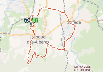
Tour Wandern von 10,8 km verfügbar auf Okzitanien, Ostpyrenäen, Laroque-des-Albères. Diese Tour wird von jeff66 vorgeschlagen.
Beschreibung
RP66 - LAROQUE - EV8 - mas montauriol - Chemin de Tanya - mas sant Julia - gués - domaine Massines - SOREDE - cellers d’en vassals - écoles - rue de la GABARRE - rue du centre - place combes - rue des micocouliers - rue du Formiguer - rue des lilas - passerelle - rue du veinat - place du christ - rue du mas Félix - gué - clos du moulin - Moulin Cassanyes - avenue de ls vallée heureuse - réservoir - piste DFCI AL C 30 - LAROQUE - Chemin de la forge - chemin de la montagne - mas Bellevue - mas mazac - piste DFCI AL 12 bis - mas bordes - réservoir - canal - gué - chapelle ruinée - rue de Roca-vella - chapelle sant Sebastia - rue des micocouliers - rue des chênes
Ort
Kommentare
Touren in der Umgebung
![Tour Wandern Laroque-des-Albères - Laroque-des-Albères, petit tour des mas - Photo](https://media.geolcdn.com/t/375/260/a38763d0-1e12-4df0-8310-6577414297bd.jpg&format=jpg&maxdim=2)
![Wandern Wandern](https://static1.geolcdn.com/sitytour/trail-icons/101.png)
Wandern
![](/images/other/stat-length.png)
![](https://static1.geolcdn.com/siteimages/upload/files/16400158638029165_repeat_loop_refresh_sync_direction_icon.png)
![Tour Wandern Laroque-des-Albères - 66 LAROQUE DES ALBERES (maison) SOREDE, par pistes DFCI AL12 et 19, mas del Ca et mas Manere, Itin.16 - Photo](https://media.geolcdn.com/t/375/260/ext.jpg?maxdim=2&url=https%3A%2F%2Fservices.sitytrail.com%2FGeolivesWS%2FDownloadMedia.ashx%3FTrailID%3D585179%26Media%3D20160616145650.jpg)
![Wandern Wandern](https://static1.geolcdn.com/sitytour/trail-icons/101.png)
Wandern
![](/images/other/stat-length.png)
![](https://static1.geolcdn.com/siteimages/upload/files/16400158638029165_repeat_loop_refresh_sync_direction_icon.png)
![Tour Wandern Laroque-des-Albères - 66 SOREDE, LAROQUE DES ALBERES, chemins des Mas - Photo](https://media.geolcdn.com/t/375/260/ext.jpg?maxdim=2&url=https%3A%2F%2Fservices.sitytrail.com%2FGeolivesWS%2FDownloadMedia.ashx%3FTrailID%3D534699%26Media%3D20160303171633.jpg)
![Wandern Wandern](https://static1.geolcdn.com/sitytour/trail-icons/101.png)
Wandern
![](/images/other/stat-length.png)
![](https://static1.geolcdn.com/siteimages/upload/files/16400158638029165_repeat_loop_refresh_sync_direction_icon.png)
![Tour Wandern Saint-André - 66 SAINT-ANDRE - SOREDE - chapelle Saint Ferreol de la Pava - Photo](https://media.geolcdn.com/t/375/260/ext.jpg?maxdim=2&url=https%3A%2F%2Fservices.sitytrail.com%2FGeolivesWS%2FDownloadMedia.ashx%3FTrailID%3D455673%26Media%3D20150807175253.jpg)
![Wandern Wandern](https://static1.geolcdn.com/sitytour/trail-icons/101.png)
Wandern
![](/images/other/stat-length.png)
![](https://static1.geolcdn.com/siteimages/upload/files/16400158638029165_repeat_loop_refresh_sync_direction_icon.png)
![Tour Wandern L'Albère - SAINT-JEAN-D'ALBERE 66 - PUIG de Sant Christau par le coll de Sant Joan - Photo](https://media.geolcdn.com/t/375/260/ext.jpg?maxdim=2&url=https%3A%2F%2Fservices.sitytrail.com%2FGeolivesWS%2FDownloadMedia.ashx%3FTrailID%3D452444%26Media%3D20150731170134.jpg)
![Wandern Wandern](https://static1.geolcdn.com/sitytour/trail-icons/101.png)
Wandern
![](/images/other/stat-length.png)
![](https://static1.geolcdn.com/siteimages/upload/files/16400158638029165_repeat_loop_refresh_sync_direction_icon.png)
![Tour Wandern Montesquieu-des-Albères - MONTESQUIEU-DES-ALBERES 66 - Les Agouillous - les chemins de l'eau dans les Albères - Photo](https://media.geolcdn.com/t/375/260/ext.jpg?maxdim=2&url=https%3A%2F%2Fservices.sitytrail.com%2FGeolivesWS%2FDownloadMedia.ashx%3FTrailID%3D451257%26Media%3D20150728182708.jpg)
![Wandern Wandern](https://static1.geolcdn.com/sitytour/trail-icons/101.png)
Wandern
![](/images/other/stat-length.png)
![](https://static1.geolcdn.com/siteimages/upload/files/16400158638029165_repeat_loop_refresh_sync_direction_icon.png)
![Tour Wandern Palau-del-Vidre - PALAU-DEL-VIDRE 66 - Boucle de Villeclare - promenade dans les vergers et cultures maraîchères - Photo](https://media.geolcdn.com/t/375/260/ext.jpg?maxdim=2&url=https%3A%2F%2Fservices.sitytrail.com%2FGeolivesWS%2FDownloadMedia.ashx%3FTrailID%3D426910%26Media%3D20150528155048.jpg)
![Wandern Wandern](https://static1.geolcdn.com/sitytour/trail-icons/101.png)
Wandern
![](/images/other/stat-length.png)
![](https://static1.geolcdn.com/siteimages/upload/files/16400158638029165_repeat_loop_refresh_sync_direction_icon.png)
![Tour Wandern Sorède - Utrera Font Miracles T - Photo](https://media.geolcdn.com/t/375/260/ext.jpg?maxdim=2&url=https%3A%2F%2Fservices.sitytrail.com%2FGeolivesWS%2FDownloadMedia.ashx%3FTrailID%3D419352%26Media%3Dfix__20150510145313.jpg)
![Wandern Wandern](https://static1.geolcdn.com/sitytour/trail-icons/101.png)
Wandern
![](/images/other/stat-length.png)
![](https://static1.geolcdn.com/siteimages/upload/files/16400158638029165_repeat_loop_refresh_sync_direction_icon.png)
![Tour Wandern Sorède - 577. 11km sorede roc des medes - Photo](https://media.geolcdn.com/t/375/260/61f4e75a-7c25-4df1-b192-fc8eca3c7acc.jpg&format=jpg&maxdim=2)
![Wandern Wandern](https://static1.geolcdn.com/sitytour/trail-icons/101.png)
Wandern
![](/images/other/stat-length.png)
![](https://static1.geolcdn.com/siteimages/upload/files/16400158638029165_repeat_loop_refresh_sync_direction_icon.png)