![](/images/other/stat-length.png)
![Tour Hybrid-Bike Saintes - Velo Rando saintes 14/08 - Photo](https://media.geolcdn.com/t/1900/400/ext.pjpeg?maxdim=2&url=https%3A%2F%2Fstatic1.geolcdn.com%2Fsiteimages%2Fupload%2Ffiles%2F1524743154velo.jpg)
Velo Rando saintes 14/08
mimosa55
Benutzer
![Länge](/images/other/stat-length.png)
Länge
29 km
![Maximale Höhe](https://static1.geolcdn.com/siteimages/upload/files/1508320355ic_sort_altitude_max_24dp.png)
Maximale Höhe
56 m
![Positive Höhendifferenz](https://static1.geolcdn.com/siteimages/upload/files/1508320355ic_sort_den_pos_24dp.png)
Positive Höhendifferenz
234 m
![Km-Effort](/images/other/stat-length.png)
Km-Effort
32 km
![Min. Höhe](https://static1.geolcdn.com/siteimages/upload/files/1508320355ic_sort_altitude_min_24dp.png)
Min. Höhe
-2 m
![Negative Höhendifferenz](https://static1.geolcdn.com/siteimages/upload/files/1508320355ic_sort_den_neg_24dp.png)
Negative Höhendifferenz
259 m
![Boucle](https://static1.geolcdn.com/siteimages/upload/files/16400158638029165_repeat_loop_refresh_sync_direction_icon.png)
Boucle
Nein
Erstellungsdatum :
2023-08-14 14:39:41.944
Letzte Änderung :
2023-08-14 17:17:47.922
![Hybrid-Bike](https://static1.geolcdn.com/sitytour/trail-icons/203.png)
2h22
Schwierigkeit : Schwierig
![Scannen Sie diesen QR-Code, um die Tour in der SityTrail-Anwendung zu öffnen](https://capi.geolives.com/qq0zvz2zws4bq2lad0pu/sitytour/trails/3771820/qr.png?size=200)
Kostenlosegpshiking-Anwendung
Über SityTrail
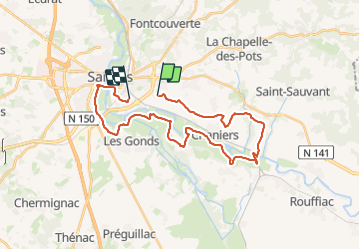
Tour Hybrid-Bike von 29 km verfügbar auf Neu-Aquitanien, Charente-Maritime, Saintes. Diese Tour wird von mimosa55 vorgeschlagen.
Beschreibung
depuis Intermarché Saintes par les chemin sur le plateau , retour sur la Charente vers Chauveau retour par le chemin blanc odyssée Vélo vers les Gonds -> retour sur Saintes.
Ort
Land:
France
Region :
Neu-Aquitanien
Abteilung/Provinz :
Charente-Maritime
Kommune :
Saintes
Standort:
Unknown
Gehen Sie:(Dec)
Gehen Sie:(UTM)
686916 ; 5067644 (30T) N.
Kommentare
Touren in der Umgebung
![Tour Pferd La Chapelle-des-Pots - Circuit des potiers - La Chapelle des Pots - Photo](https://media.geolcdn.com/t/375/260/ext.jpg?maxdim=2&url=https%3A%2F%2Fservices.sitytrail.com%2FGeolivesWS%2FDownloadMedia.ashx%3FTrailID%3D112268%26Media%3D10265_6.jpg)
![Pferd Pferd](https://static1.geolcdn.com/sitytour/trail-icons/300.png)
Circuit des potiers - La Chapelle des Pots
Pferd
Einfach
(1)
La Chapelle-des-Pots,
Neu-Aquitanien,
Charente-Maritime,
France
![](/images/other/stat-length.png)
7,2 km | 8,5 km-effort
1h 19min
![](https://static1.geolcdn.com/siteimages/upload/files/16400158638029165_repeat_loop_refresh_sync_direction_icon.png)
Ja
![Tour Wandern La Chapelle-des-Pots - la Chapelle des Pots ( D ROUSSET) - Photo](https://media.geolcdn.com/t/375/260/ext.jpg?maxdim=2&url=https%3A%2F%2Fstatic1.geolcdn.com%2Fsiteimages%2Fupload%2Ffiles%2F1553511878bg_sport_marche.png)
![Wandern Wandern](https://static1.geolcdn.com/sitytour/trail-icons/101.png)
la Chapelle des Pots ( D ROUSSET)
Wandern
Medium
(1)
La Chapelle-des-Pots,
Neu-Aquitanien,
Charente-Maritime,
France
![](/images/other/stat-length.png)
7,8 km | 8,8 km-effort
2h 40min
![](https://static1.geolcdn.com/siteimages/upload/files/16400158638029165_repeat_loop_refresh_sync_direction_icon.png)
Ja
![Tour Wandern Chaniers - port huble - Photo](https://media.geolcdn.com/t/375/260/ba0c962b-94d4-49b1-ba68-5d28da08b6da.jpg&format=jpg&maxdim=2)
![Wandern Wandern](https://static1.geolcdn.com/sitytour/trail-icons/101.png)
port huble
Wandern
Medium
Chaniers,
Neu-Aquitanien,
Charente-Maritime,
France
![](/images/other/stat-length.png)
5,6 km | 6,5 km-effort
1h 39min
![](https://static1.geolcdn.com/siteimages/upload/files/16400158638029165_repeat_loop_refresh_sync_direction_icon.png)
Ja
![Tour Wandern La Chapelle-des-Pots - La Chapelle des Pots - Asphodèles - Photo](https://media.geolcdn.com/t/375/260/ext.jpg?maxdim=2&url=https%3A%2F%2Fstatic1.geolcdn.com%2Fsiteimages%2Fupload%2Ffiles%2F1553511878bg_sport_marche.png)
![Wandern Wandern](https://static1.geolcdn.com/sitytour/trail-icons/101.png)
La Chapelle des Pots - Asphodèles
Wandern
Einfach
(1)
La Chapelle-des-Pots,
Neu-Aquitanien,
Charente-Maritime,
France
![](/images/other/stat-length.png)
7,4 km | 8,7 km-effort
2h 5min
![](https://static1.geolcdn.com/siteimages/upload/files/16400158638029165_repeat_loop_refresh_sync_direction_icon.png)
Ja
![Tour Wandern Saintes - saintes (essais 01) - Photo](https://media.geolcdn.com/t/375/260/ext.jpg?maxdim=2&url=https%3A%2F%2Fstatic1.geolcdn.com%2Fsiteimages%2Fupload%2Ffiles%2F1553511878bg_sport_marche.png)
![Wandern Wandern](https://static1.geolcdn.com/sitytour/trail-icons/101.png)
saintes (essais 01)
Wandern
Sehr leicht
(1)
Saintes,
Neu-Aquitanien,
Charente-Maritime,
France
![](/images/other/stat-length.png)
9 km | 10,4 km-effort
2h 1min
![](https://static1.geolcdn.com/siteimages/upload/files/16400158638029165_repeat_loop_refresh_sync_direction_icon.png)
Ja
![Tour Wandern Saintes - JFT YB Etape11 8-5 -2014 - Photo](https://media.geolcdn.com/t/375/260/ext.jpg?maxdim=2&url=https%3A%2F%2Fservices.sitytrail.com%2FGeolivesWS%2FDownloadMedia.ashx%3FTrailID%3D280229%26Media%3Dfix__20140508074818.jpg)
![Wandern Wandern](https://static1.geolcdn.com/sitytour/trail-icons/101.png)
JFT YB Etape11 8-5 -2014
Wandern
Medium
Saintes,
Neu-Aquitanien,
Charente-Maritime,
France
![](/images/other/stat-length.png)
30 km | 33 km-effort
6h 10min
![](https://static1.geolcdn.com/siteimages/upload/files/16400158638029165_repeat_loop_refresh_sync_direction_icon.png)
Nein
![Tour Mountainbike La Chapelle-des-Pots - Circuit des potiers - La Chapelle des Pots - Photo](https://media.geolcdn.com/t/375/260/ext.jpg?maxdim=2&url=https%3A%2F%2Fservices.sitytrail.com%2FGeolivesWS%2FDownloadMedia.ashx%3FTrailID%3D112267%26Media%3D10265_6.jpg)
![Mountainbike Mountainbike](https://static1.geolcdn.com/sitytour/trail-icons/202.png)
Circuit des potiers - La Chapelle des Pots
Mountainbike
Einfach
La Chapelle-des-Pots,
Neu-Aquitanien,
Charente-Maritime,
France
![](/images/other/stat-length.png)
7,2 km | 8,5 km-effort
34min
![](https://static1.geolcdn.com/siteimages/upload/files/16400158638029165_repeat_loop_refresh_sync_direction_icon.png)
Ja
![Tour Wandern La Chapelle-des-Pots - Circuit des potiers - La Chapelle des Pots - Photo](https://media.geolcdn.com/t/375/260/ext.jpg?maxdim=2&url=https%3A%2F%2Fservices.sitytrail.com%2FGeolivesWS%2FDownloadMedia.ashx%3FTrailID%3D112266%26Media%3D10265_6.jpg)
![Wandern Wandern](https://static1.geolcdn.com/sitytour/trail-icons/101.png)
Circuit des potiers - La Chapelle des Pots
Wandern
Medium
La Chapelle-des-Pots,
Neu-Aquitanien,
Charente-Maritime,
France
![](/images/other/stat-length.png)
7,2 km | 8,5 km-effort
2h 0min
![](https://static1.geolcdn.com/siteimages/upload/files/16400158638029165_repeat_loop_refresh_sync_direction_icon.png)
Ja
![Tour Wandern Chaniers - moulin de la vaine - Vallée du Bourru - Photo](https://media.geolcdn.com/t/375/260/cbba95db-44f0-445a-b3e3-1a4b052782e0.jpg&format=jpg&maxdim=2)
![Wandern Wandern](https://static1.geolcdn.com/sitytour/trail-icons/101.png)
moulin de la vaine - Vallée du Bourru
Wandern
Einfach
Chaniers,
Neu-Aquitanien,
Charente-Maritime,
France
![](/images/other/stat-length.png)
6,9 km | 7,8 km-effort
2h 15min
![](https://static1.geolcdn.com/siteimages/upload/files/16400158638029165_repeat_loop_refresh_sync_direction_icon.png)
Ja