![](/images/other/stat-length.png)
![Tour Wandern Négrondes - Négrondes Fontaines longue 13km - Photo](https://media.geolcdn.com/t/1900/400/ext.pjpeg?maxdim=2&url=https%3A%2F%2Fstatic1.geolcdn.com%2Fsiteimages%2Fupload%2Ffiles%2F1553511878bg_sport_marche.png)
Négrondes Fontaines longue 13km
YV24
Benutzer
![Länge](/images/other/stat-length.png)
Länge
12,8 km
![Maximale Höhe](https://static1.geolcdn.com/siteimages/upload/files/1508320355ic_sort_altitude_max_24dp.png)
Maximale Höhe
227 m
![Positive Höhendifferenz](https://static1.geolcdn.com/siteimages/upload/files/1508320355ic_sort_den_pos_24dp.png)
Positive Höhendifferenz
187 m
![Km-Effort](/images/other/stat-length.png)
Km-Effort
15,3 km
![Min. Höhe](https://static1.geolcdn.com/siteimages/upload/files/1508320355ic_sort_altitude_min_24dp.png)
Min. Höhe
144 m
![Negative Höhendifferenz](https://static1.geolcdn.com/siteimages/upload/files/1508320355ic_sort_den_neg_24dp.png)
Negative Höhendifferenz
186 m
![Boucle](https://static1.geolcdn.com/siteimages/upload/files/16400158638029165_repeat_loop_refresh_sync_direction_icon.png)
Boucle
Ja
Erstellungsdatum :
2015-02-23 00:00:00.0
Letzte Änderung :
2015-02-23 00:00:00.0
![Wandern](https://static1.geolcdn.com/sitytour/trail-icons/101.png)
3h20
Schwierigkeit : Einfach
![Scannen Sie diesen QR-Code, um die Tour in der SityTrail-Anwendung zu öffnen](https://capi.geolives.com/qq0zvz2zws4bq2lad0pu/sitytour/trails/377018/qr.png?size=200)
Kostenlosegpshiking-Anwendung
Über SityTrail
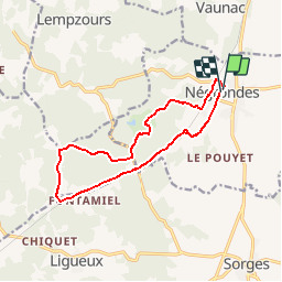
Tour Wandern von 12,8 km verfügbar auf Neu-Aquitanien, Dordogne, Négrondes. Diese Tour wird von YV24 vorgeschlagen.
Beschreibung
Variante PDIPR Boucle des Fontaines allongée à 13 km.
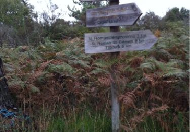
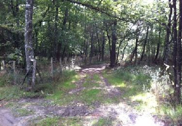
Environ 2km de route entre les Rebières et après Rochemorin. Praticable en tout temps. Pas de balisage entre les Rebières et Fontaine de la Roche.
Ort
Land:
France
Region :
Neu-Aquitanien
Abteilung/Provinz :
Dordogne
Kommune :
Négrondes
Standort:
Unknown
Gehen Sie:(Dec)
Gehen Sie:(UTM)
332720 ; 5023568 (31T) N.
Kommentare
Touren in der Umgebung
![Tour sport Sorges et Ligueux en Périgord - 2020-09-03_17h34m25_20-10-20 Ligueux - Photo](https://media.geolcdn.com/t/375/260/ext.jpg?maxdim=2&url=https%3A%2F%2Fsecurestorage.geolives.com%2Fsitytour%2Ftrail-bg%2Fdefault.jpg)
2020-09-03_17h34m25_20-10-20 Ligueux
sport
Sehr leicht
(1)
Sorges et Ligueux en Périgord,
Neu-Aquitanien,
Dordogne,
France
![](/images/other/stat-length.png)
10,5 km | 13,4 km-effort
Unbekannt
![](https://static1.geolcdn.com/siteimages/upload/files/16400158638029165_repeat_loop_refresh_sync_direction_icon.png)
Ja
![Tour Wandern Sorges et Ligueux en Périgord - Sorges Causses et sous bois 10 km - Photo](https://media.geolcdn.com/t/375/260/ext.jpg?maxdim=2&url=https%3A%2F%2Fstatic1.geolcdn.com%2Fsiteimages%2Fupload%2Ffiles%2F1553511878bg_sport_marche.png)
![Wandern Wandern](https://static1.geolcdn.com/sitytour/trail-icons/101.png)
Sorges Causses et sous bois 10 km
Wandern
Einfach
(1)
Sorges et Ligueux en Périgord,
Neu-Aquitanien,
Dordogne,
France
![](/images/other/stat-length.png)
9,9 km | 12,6 km-effort
1h 49min
![](https://static1.geolcdn.com/siteimages/upload/files/16400158638029165_repeat_loop_refresh_sync_direction_icon.png)
Ja
![Tour Wandern Sorges et Ligueux en Périgord - Sorges Téléthon 2013 11km - Photo](https://media.geolcdn.com/t/375/260/ext.jpg?maxdim=2&url=https%3A%2F%2Fstatic1.geolcdn.com%2Fsiteimages%2Fupload%2Ffiles%2F1553511878bg_sport_marche.png)
![Wandern Wandern](https://static1.geolcdn.com/sitytour/trail-icons/101.png)
Sorges Téléthon 2013 11km
Wandern
Einfach
(1)
Sorges et Ligueux en Périgord,
Neu-Aquitanien,
Dordogne,
France
![](/images/other/stat-length.png)
11 km | 13,2 km-effort
2h 57min
![](https://static1.geolcdn.com/siteimages/upload/files/16400158638029165_repeat_loop_refresh_sync_direction_icon.png)
Ja
![Tour Wandern Sorges et Ligueux en Périgord - Marche du dimanche 15 janvier à Ligueux - Photo](https://media.geolcdn.com/t/375/260/ca66f548-4426-4827-980d-dc4041496b72.jpg&format=jpg&maxdim=2)
![Wandern Wandern](https://static1.geolcdn.com/sitytour/trail-icons/101.png)
Marche du dimanche 15 janvier à Ligueux
Wandern
Einfach
Sorges et Ligueux en Périgord,
Neu-Aquitanien,
Dordogne,
France
![](/images/other/stat-length.png)
6,8 km | 8,6 km-effort
1h 39min
![](https://static1.geolcdn.com/siteimages/upload/files/16400158638029165_repeat_loop_refresh_sync_direction_icon.png)
Nein
![Tour Wandern Sorges et Ligueux en Périgord - Boucle de l'Abbatiale - Photo](https://media.geolcdn.com/t/375/260/9612e021-d9e0-4a16-be1e-ceb9f3a734d7.jpg&format=jpg&maxdim=2)
![Wandern Wandern](https://static1.geolcdn.com/sitytour/trail-icons/101.png)
Boucle de l'Abbatiale
Wandern
Einfach
Sorges et Ligueux en Périgord,
Neu-Aquitanien,
Dordogne,
France
![](/images/other/stat-length.png)
7,3 km | 8,9 km-effort
2h 1min
![](https://static1.geolcdn.com/siteimages/upload/files/16400158638029165_repeat_loop_refresh_sync_direction_icon.png)
Ja
![Tour Wandern Sorges et Ligueux en Périgord - De Sorges à Perigueux sur la voie de Compostelle - Photo](https://media.geolcdn.com/t/375/260/4aaf4236-90c5-474d-8de9-7f6175f80c96.jpeg&format=jpg&maxdim=2)
![Wandern Wandern](https://static1.geolcdn.com/sitytour/trail-icons/101.png)
De Sorges à Perigueux sur la voie de Compostelle
Wandern
Sehr schwierig
Sorges et Ligueux en Périgord,
Neu-Aquitanien,
Dordogne,
France
![](/images/other/stat-length.png)
25 km | 31 km-effort
5h 26min
![](https://static1.geolcdn.com/siteimages/upload/files/16400158638029165_repeat_loop_refresh_sync_direction_icon.png)
Nein
![Tour Wandern Eyzerac - La Servolle 2 - Photo](https://media.geolcdn.com/t/375/260/ext.jpg?maxdim=2&url=https%3A%2F%2Fservices.sitytrail.com%2FGeolivesWS%2FDownloadMedia.ashx%3FTrailID%3D226050%26Media%3D20131008110344.jpg)
![Wandern Wandern](https://static1.geolcdn.com/sitytour/trail-icons/101.png)
La Servolle 2
Wandern
Einfach
Eyzerac,
Neu-Aquitanien,
Dordogne,
France
![](/images/other/stat-length.png)
12,4 km | 14,9 km-effort
3h 16min
![](https://static1.geolcdn.com/siteimages/upload/files/16400158638029165_repeat_loop_refresh_sync_direction_icon.png)
Ja
![Tour Wandern Sorges et Ligueux en Périgord - Boucle des châteaux - Photo](https://media.geolcdn.com/t/375/260/ba5fb264-42c9-43e2-90fa-f6bdc036a39c.jpg&format=jpg&maxdim=2)
![Wandern Wandern](https://static1.geolcdn.com/sitytour/trail-icons/101.png)
Boucle des châteaux
Wandern
Schwierig
Sorges et Ligueux en Périgord,
Neu-Aquitanien,
Dordogne,
France
![](/images/other/stat-length.png)
14,4 km | 17,2 km-effort
3h 54min
![](https://static1.geolcdn.com/siteimages/upload/files/16400158638029165_repeat_loop_refresh_sync_direction_icon.png)
Ja
![Tour Wandern Vaunac - Vaunac-St Chavit - Photo](https://media.geolcdn.com/t/375/260/ext.jpg?maxdim=2&url=https%3A%2F%2Fservices.sitytrail.com%2FGeolivesWS%2FDownloadMedia.ashx%3FTrailID%3D226520%26Media%3D20131011113305.jpg)
![Wandern Wandern](https://static1.geolcdn.com/sitytour/trail-icons/101.png)
Vaunac-St Chavit
Wandern
Sehr leicht
Vaunac,
Neu-Aquitanien,
Dordogne,
France
![](/images/other/stat-length.png)
9,9 km | 12,6 km-effort
2h 39min
![](https://static1.geolcdn.com/siteimages/upload/files/16400158638029165_repeat_loop_refresh_sync_direction_icon.png)
Ja