![](/images/other/stat-length.png)
![Tour Wandern Aiseau-Presles - PRESLES _ Marche Fédérale _ HT _ 13/08/2023, - Photo](https://media.geolcdn.com/t/1900/400/cc609dd8-b194-460a-9905-6ea404b701d3.jpg&format=pjpeg&maxdim=2)
PRESLES _ Marche Fédérale _ HT _ 13/08/2023,
jeangulu
Benutzer
![Länge](/images/other/stat-length.png)
Länge
18,9 km
![Maximale Höhe](https://static1.geolcdn.com/siteimages/upload/files/1508320355ic_sort_altitude_max_24dp.png)
Maximale Höhe
243 m
![Positive Höhendifferenz](https://static1.geolcdn.com/siteimages/upload/files/1508320355ic_sort_den_pos_24dp.png)
Positive Höhendifferenz
313 m
![Km-Effort](/images/other/stat-length.png)
Km-Effort
23 km
![Min. Höhe](https://static1.geolcdn.com/siteimages/upload/files/1508320355ic_sort_altitude_min_24dp.png)
Min. Höhe
105 m
![Negative Höhendifferenz](https://static1.geolcdn.com/siteimages/upload/files/1508320355ic_sort_den_neg_24dp.png)
Negative Höhendifferenz
313 m
![Boucle](https://static1.geolcdn.com/siteimages/upload/files/16400158638029165_repeat_loop_refresh_sync_direction_icon.png)
Boucle
Ja
Erstellungsdatum :
2023-08-13 08:16:26.322
Letzte Änderung :
2023-08-13 12:57:37.489
![Wandern](https://static1.geolcdn.com/sitytour/trail-icons/101.png)
4h40
Schwierigkeit : Medium
![Scannen Sie diesen QR-Code, um die Tour in der SityTrail-Anwendung zu öffnen](https://capi.geolives.com/qq0zvz2zws4bq2lad0pu/sitytour/trails/3769958/qr.png?size=200)
Kostenlosegpshiking-Anwendung
Über SityTrail
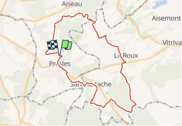
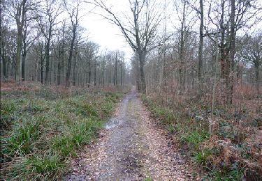
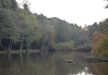
Tour Wandern von 18,9 km verfügbar auf Wallonien, Hennegau, Aiseau-Presles. Diese Tour wird von jeangulu vorgeschlagen.
Beschreibung
Organisateur : HT 006 _ CLUB PÉDESTRE ÉCUREUIL DE CHATELET.
- 3ème Marche des Mirabelles.
Point de départ : École Saint Joseph _ Rue des Prés Burniaux _ 6250 - PRESLES.
Carte IGN : 47/5
Ort
Land:
Belgium
Region :
Wallonien
Abteilung/Provinz :
Hennegau
Kommune :
Aiseau-Presles
Standort:
Unknown
Gehen Sie:(Dec)
Gehen Sie:(UTM)
612259 ; 5582965 (31U) N.
Kommentare
Touren in der Umgebung
![Tour Wandern Aiseau-Presles - D'Aiseau vers l'abbaye d'Oignies par la vallee de la Biesme - Photo](https://media.geolcdn.com/t/375/260/ext.jpg?maxdim=2&url=https%3A%2F%2Fstatic1.geolcdn.com%2Fsiteimages%2Fupload%2Ffiles%2F1553511878bg_sport_marche.png)
![Wandern Wandern](https://static1.geolcdn.com/sitytour/trail-icons/101.png)
D'Aiseau vers l'abbaye d'Oignies par la vallee de la Biesme
Wandern
Einfach
(7)
Aiseau-Presles,
Wallonien,
Hennegau,
Belgium
![](/images/other/stat-length.png)
9,2 km | 11,5 km-effort
2h 20min
![](https://static1.geolcdn.com/siteimages/upload/files/16400158638029165_repeat_loop_refresh_sync_direction_icon.png)
Ja
![Tour Wandern Fosses-la-Ville - Balade à Sart-Eustache - Photo](https://media.geolcdn.com/t/375/260/ext.jpg?maxdim=2&url=https%3A%2F%2Fservices.sitytrail.com%2FGeolivesWS%2FDownloadMedia.ashx%3FTrailID%3D745477%26Media%3D0d9905aa-0e68-4255-ba20-1d4f668867f0.JPG)
![Wandern Wandern](https://static1.geolcdn.com/sitytour/trail-icons/101.png)
Balade à Sart-Eustache
Wandern
Einfach
(1)
Fosses-la-Ville,
Wallonien,
Namur,
Belgium
![](/images/other/stat-length.png)
11,2 km | 13,9 km-effort
2h 59min
![](https://static1.geolcdn.com/siteimages/upload/files/16400158638029165_repeat_loop_refresh_sync_direction_icon.png)
Ja
![Tour Wandern Châtelet - Balade à Châtelet - Des Marchaux à Sébastopol - Photo](https://media.geolcdn.com/t/375/260/ext.jpg?maxdim=2&url=https%3A%2F%2Fservices.sitytrail.com%2FGeolivesWS%2FDownloadMedia.ashx%3FTrailID%3D410537%26Media%3Dac6fc019-bf8a-4700-8d9f-90a7a3df3f48.JPG)
![Wandern Wandern](https://static1.geolcdn.com/sitytour/trail-icons/101.png)
Balade à Châtelet - Des Marchaux à Sébastopol
Wandern
Einfach
(4)
Châtelet,
Wallonien,
Hennegau,
Belgium
![](/images/other/stat-length.png)
10,1 km | 12,3 km-effort
2h 40min
![](https://static1.geolcdn.com/siteimages/upload/files/16400158638029165_repeat_loop_refresh_sync_direction_icon.png)
Ja
![Tour Wandern Châtelet - Balade à Bouffioulx - Photo](https://media.geolcdn.com/t/375/260/ext.jpg?maxdim=2&url=https%3A%2F%2Fservices.sitytrail.com%2FGeolivesWS%2FDownloadMedia.ashx%3FTrailID%3D330019%26Media%3D73210f4e-e164-4450-bb6c-9ce2515b6ee4.JPG)
![Wandern Wandern](https://static1.geolcdn.com/sitytour/trail-icons/101.png)
Balade à Bouffioulx
Wandern
Medium
(1)
Châtelet,
Wallonien,
Hennegau,
Belgium
![](/images/other/stat-length.png)
9,3 km | 12,7 km-effort
2h 39min
![](https://static1.geolcdn.com/siteimages/upload/files/16400158638029165_repeat_loop_refresh_sync_direction_icon.png)
Ja
![Tour Wandern Châtelet - De Bouffioulx à Acoz par le village de Joncret - Photo](https://media.geolcdn.com/t/375/260/ext.jpg?maxdim=2&url=https%3A%2F%2Fservices.sitytrail.com%2FGeolivesWS%2FDownloadMedia.ashx%3FTrailID%3D113314%26Media%3Dffb52b60-d779-4a97-95fd-306bccfd703c.JPG)
![Wandern Wandern](https://static1.geolcdn.com/sitytour/trail-icons/101.png)
De Bouffioulx à Acoz par le village de Joncret
Wandern
Einfach
Châtelet,
Wallonien,
Hennegau,
Belgium
![](/images/other/stat-length.png)
13,8 km | 16,8 km-effort
3h 20min
![](https://static1.geolcdn.com/siteimages/upload/files/16400158638029165_repeat_loop_refresh_sync_direction_icon.png)
Ja
![Tour Wandern Fosses-la-Ville - Sart eustache - Photo](https://media.geolcdn.com/t/375/260/ext.jpg?maxdim=2&url=https%3A%2F%2Fstatic1.geolcdn.com%2Fsiteimages%2Fupload%2Ffiles%2F1553511878bg_sport_marche.png)
![Wandern Wandern](https://static1.geolcdn.com/sitytour/trail-icons/101.png)
Sart eustache
Wandern
(1)
Fosses-la-Ville,
Wallonien,
Namur,
Belgium
![](/images/other/stat-length.png)
11,8 km | 14,4 km-effort
2h 36min
![](https://static1.geolcdn.com/siteimages/upload/files/16400158638029165_repeat_loop_refresh_sync_direction_icon.png)
Ja
![Zu Fuß Zu Fuß](https://static1.geolcdn.com/sitytour/trail-icons/100.png)
Promenade_du_diable_10,5km
Zu Fuß
Medium
(1)
Fosses-la-Ville,
Wallonien,
Namur,
Belgium
![](/images/other/stat-length.png)
10,4 km | 13 km-effort
Unbekannt
![](https://static1.geolcdn.com/siteimages/upload/files/16400158638029165_repeat_loop_refresh_sync_direction_icon.png)
Ja
![Tour Wandern Gerpinnes - Gerpinnes - Balade en verte campagne - Photo](https://media.geolcdn.com/t/375/260/ext.jpg?maxdim=2&url=https%3A%2F%2Fstatic1.geolcdn.com%2Fsiteimages%2Fupload%2Ffiles%2F1553511878bg_sport_marche.png)
![Wandern Wandern](https://static1.geolcdn.com/sitytour/trail-icons/101.png)
Gerpinnes - Balade en verte campagne
Wandern
Einfach
(2)
Gerpinnes,
Wallonien,
Hennegau,
Belgium
![](/images/other/stat-length.png)
11,2 km | 13,5 km-effort
2h 50min
![](https://static1.geolcdn.com/siteimages/upload/files/16400158638029165_repeat_loop_refresh_sync_direction_icon.png)
Ja
![Tour Wandern Gerpinnes - Le sentier eco - pedagogique du Bois de Gougnies - Photo](https://media.geolcdn.com/t/375/260/ext.jpg?maxdim=2&url=https%3A%2F%2Fstatic1.geolcdn.com%2Fsiteimages%2Fupload%2Ffiles%2F1553511878bg_sport_marche.png)
![Wandern Wandern](https://static1.geolcdn.com/sitytour/trail-icons/101.png)
Le sentier eco - pedagogique du Bois de Gougnies
Wandern
Sehr leicht
(5)
Gerpinnes,
Wallonien,
Hennegau,
Belgium
![](/images/other/stat-length.png)
3,9 km | 5,1 km-effort
1h 0min
![](https://static1.geolcdn.com/siteimages/upload/files/16400158638029165_repeat_loop_refresh_sync_direction_icon.png)
Ja