![](/images/other/stat-length.png)
![Tour Wandern Feings - [Itinéraire] Brochard - Le Val-Dieu - Photo](https://media.geolcdn.com/t/1900/400/ext.pjpeg?maxdim=2&url=https%3A%2F%2Fstatic1.geolcdn.com%2Fsiteimages%2Fupload%2Ffiles%2F1553511878bg_sport_marche.png)
[Itinéraire] Brochard - Le Val-Dieu
ODDAD78
Benutzer
![Länge](/images/other/stat-length.png)
![Maximale Höhe](https://static1.geolcdn.com/siteimages/upload/files/1508320355ic_sort_altitude_max_24dp.png)
![Positive Höhendifferenz](https://static1.geolcdn.com/siteimages/upload/files/1508320355ic_sort_den_pos_24dp.png)
![Km-Effort](/images/other/stat-length.png)
![Min. Höhe](https://static1.geolcdn.com/siteimages/upload/files/1508320355ic_sort_altitude_min_24dp.png)
![Negative Höhendifferenz](https://static1.geolcdn.com/siteimages/upload/files/1508320355ic_sort_den_neg_24dp.png)
![Boucle](https://static1.geolcdn.com/siteimages/upload/files/16400158638029165_repeat_loop_refresh_sync_direction_icon.png)
![Wandern](https://static1.geolcdn.com/sitytour/trail-icons/101.png)
2h03
Schwierigkeit : Medium
![Scannen Sie diesen QR-Code, um die Tour in der SityTrail-Anwendung zu öffnen](https://capi.geolives.com/qq0zvz2zws4bq2lad0pu/sitytour/trails/3769178/qr.png?size=200)
Kostenlosegpshiking-Anwendung
Über SityTrail
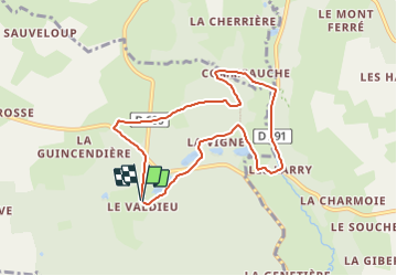
Tour Wandern von 7,3 km verfügbar auf Normandie, Orne, Feings. Diese Tour wird von ODDAD78 vorgeschlagen.
Beschreibung
Prendre le chemin en cailloux devant la Chartreuse du Val-Dieu puis le chemin de terre longeant l’étang et la lisière de la forêt. (GR22)
1. Couper la D281 : suivre en face « La Vigne »menant à l’étang de la Courraierie.
2. Juste avant l’entrée du chemin privé menant à la Vigne, bifurquer à gauche. Le sentier serpente en
lisière de bois.
3. Abandonner le GR en descendant à droite (chemin parfois boueux) pour déboucher au Moulin de
la Vigne face au hangar d’une ancienne entreprise d’embouteillage d’eau de source. Merci de rester sur le chemin et de respecter cette propriété privée. Continuer tout droit en empruntant la Chaussée de l’étang et gagner la D281.
4. A gauche pour rejoindre Brochard. Après le pont sur la Commeauche, prendre à gauche la D291, direction Malétable (Prudence) passer devant la fontaine de Madame Jeanne (sur votre gauche).
5. 200 m après Le Bois de Fauverolles, tourner à gauche. Franchir à nouveau La Commeauche. Au hameau du même nom, prendre à gauche un chemin de terre (GR22). Passez à gué le ruisseau du Bignon et obliquer à gauche. Le chemin mène à un étang masqué par une levée de terre. Vous longez la tourbière de la Commeauche.
6. A une croisée de chemin, continuer le GR par la gauche en lisière de la forêt domaniale.
7. A une intersection, abandonner le GR qui continue tout droit et monter à droite la ligne de parcelles
(terrain gras parfois). Au sortir de la forêt, continuer sur un chemin empierré.
8. Traverser la D600 et prendre en face vers le Grand Boulay. Poursuivre par un chemin de terre qui
longe les douves et débouche après un coude sur la D281 (si barrière : l’ouvrir et la fermer ou
utiliser le passage d’homme).
9. Prendre à gauche la D281.(Prudence) Puis à droite au carrefour pour retourner au Val-Dieu.
Ort
Kommentare
Touren in der Umgebung
![Tour Zu Fuß Longny les Villages - Attelage - Forêt et Panoramas - forêt de Réno-Valdieu - Photo](https://media.geolcdn.com/t/375/260/db99a0ed-9413-4500-8368-446623bccd86.jpeg&format=jpg&maxdim=2)
![Zu Fuß Zu Fuß](https://static1.geolcdn.com/sitytour/trail-icons/100.png)
Zu Fuß
![](/images/other/stat-length.png)
![](https://static1.geolcdn.com/siteimages/upload/files/16400158638029165_repeat_loop_refresh_sync_direction_icon.png)
![Tour Wandern Longny les Villages - La Fonte - Malétable 7,8 km - Photo](https://media.geolcdn.com/t/375/260/58715638-860a-4ade-9990-a9918a4f42a8.jpeg&format=jpg&maxdim=2)
![Wandern Wandern](https://static1.geolcdn.com/sitytour/trail-icons/101.png)
Wandern
![](/images/other/stat-length.png)
![](https://static1.geolcdn.com/siteimages/upload/files/16400158638029165_repeat_loop_refresh_sync_direction_icon.png)
![Tour Wandern Feings - Perche-Le Valdieu - Forêt de Réno-Valdieu - - Photo](https://media.geolcdn.com/t/375/260/3680a9e7-0933-4c18-9cee-f8b32abef75f.jpg&format=jpg&maxdim=2)
![Wandern Wandern](https://static1.geolcdn.com/sitytour/trail-icons/101.png)
Wandern
![](/images/other/stat-length.png)
![](https://static1.geolcdn.com/siteimages/upload/files/16400158638029165_repeat_loop_refresh_sync_direction_icon.png)
![Tour Pferd Feings - Attelage en forêt domaniale de Reno-Valdieu - Feings - Photo](https://media.geolcdn.com/t/375/260/ext.jpg?maxdim=2&url=https%3A%2F%2Fservices.sitytrail.com%2FGeolivesWS%2FDownloadMedia.ashx%3FTrailID%3D112045%26Media%3D9573_2.jpg)
![Pferd Pferd](https://static1.geolcdn.com/sitytour/trail-icons/300.png)
Pferd
![](/images/other/stat-length.png)
![](https://static1.geolcdn.com/siteimages/upload/files/16400158638029165_repeat_loop_refresh_sync_direction_icon.png)
![Tour Wandern Tourouvre au Perche - Bellegarde - Autheuil - Photo](https://media.geolcdn.com/t/375/260/ext.jpg?maxdim=2&url=https%3A%2F%2Fservices.sitytrail.com%2FGeolivesWS%2FDownloadMedia.ashx%3FTrailID%3D111657%26Media%3D7895_1.jpg)
![Wandern Wandern](https://static1.geolcdn.com/sitytour/trail-icons/101.png)
Wandern
![](/images/other/stat-length.png)
![](https://static1.geolcdn.com/siteimages/upload/files/16400158638029165_repeat_loop_refresh_sync_direction_icon.png)
![Tour Pferd Feings - Attelage - Forêt et Panoramas - forêt de Réno-Valdieu - Photo](https://media.geolcdn.com/t/375/260/ext.jpg?maxdim=2&url=https%3A%2F%2Fservices.sitytrail.com%2FGeolivesWS%2FDownloadMedia.ashx%3FTrailID%3D111648%26Media%3D7888_2.jpg)
![Pferd Pferd](https://static1.geolcdn.com/sitytour/trail-icons/300.png)
Pferd
![](/images/other/stat-length.png)
![](https://static1.geolcdn.com/siteimages/upload/files/16400158638029165_repeat_loop_refresh_sync_direction_icon.png)
![Tour Mountainbike Feings - Attelage - Forêt et Panoramas - forêt de Réno-Valdieu - Photo](https://media.geolcdn.com/t/375/260/ext.jpg?maxdim=2&url=https%3A%2F%2Fservices.sitytrail.com%2FGeolivesWS%2FDownloadMedia.ashx%3FTrailID%3D111647%26Media%3D7888_2.jpg)
![Mountainbike Mountainbike](https://static1.geolcdn.com/sitytour/trail-icons/202.png)
Mountainbike
![](/images/other/stat-length.png)
![](https://static1.geolcdn.com/siteimages/upload/files/16400158638029165_repeat_loop_refresh_sync_direction_icon.png)
![Tour Wandern Feings - Attelage - Forêt et Panoramas - forêt de Réno-Valdieu - Photo](https://media.geolcdn.com/t/375/260/ext.jpg?maxdim=2&url=https%3A%2F%2Fservices.sitytrail.com%2FGeolivesWS%2FDownloadMedia.ashx%3FTrailID%3D111646%26Media%3D7888_2.jpg)
![Wandern Wandern](https://static1.geolcdn.com/sitytour/trail-icons/101.png)
Wandern
![](/images/other/stat-length.png)
![](https://static1.geolcdn.com/siteimages/upload/files/16400158638029165_repeat_loop_refresh_sync_direction_icon.png)
![Tour Wandern Saint-Mard-de-Réno - [Itinéraire] La chute de Beillard - Départ de Saint-Mard - Photo](https://media.geolcdn.com/t/375/260/ext.jpg?maxdim=2&url=https%3A%2F%2Fstatic1.geolcdn.com%2Fsiteimages%2Fupload%2Ffiles%2F1553511878bg_sport_marche.png)
![Wandern Wandern](https://static1.geolcdn.com/sitytour/trail-icons/101.png)
Wandern
![](/images/other/stat-length.png)
![](https://static1.geolcdn.com/siteimages/upload/files/16400158638029165_repeat_loop_refresh_sync_direction_icon.png)