![](/images/other/stat-length.png)
![Tour Wandern Valgrisenche - Jour 2 - Refuge degli Angeli - Refuge de l'Archeboc - Photo](https://media.geolcdn.com/t/1900/400/ext.pjpeg?maxdim=2&url=https%3A%2F%2Fstatic1.geolcdn.com%2Fsiteimages%2Fupload%2Ffiles%2F1553511878bg_sport_marche.png)
Jour 2 - Refuge degli Angeli - Refuge de l'Archeboc
i20
Benutzer
![Länge](/images/other/stat-length.png)
![Maximale Höhe](https://static1.geolcdn.com/siteimages/upload/files/1508320355ic_sort_altitude_max_24dp.png)
![Positive Höhendifferenz](https://static1.geolcdn.com/siteimages/upload/files/1508320355ic_sort_den_pos_24dp.png)
![Km-Effort](/images/other/stat-length.png)
![Min. Höhe](https://static1.geolcdn.com/siteimages/upload/files/1508320355ic_sort_altitude_min_24dp.png)
![Negative Höhendifferenz](https://static1.geolcdn.com/siteimages/upload/files/1508320355ic_sort_den_neg_24dp.png)
![Boucle](https://static1.geolcdn.com/siteimages/upload/files/16400158638029165_repeat_loop_refresh_sync_direction_icon.png)
![Wandern](https://static1.geolcdn.com/sitytour/trail-icons/101.png)
6h13
Schwierigkeit : Sehr schwierig
![Scannen Sie diesen QR-Code, um die Tour in der SityTrail-Anwendung zu öffnen](https://capi.geolives.com/qq0zvz2zws4bq2lad0pu/sitytour/trails/3759744/qr.png?size=200)
Kostenlosegpshiking-Anwendung
Über SityTrail
Tour Wandern von 14,2 km verfügbar auf Aostatal, Unbekannt, Valgrisenche. Diese Tour wird von i20 vorgeschlagen.
Beschreibung
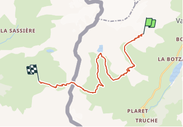
Meilleure carte = L'Escursionista #3 (rouge)
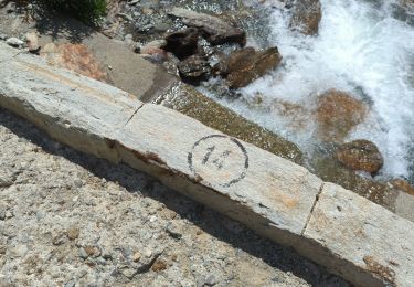
Depuis le refuge, prendre le chemin #16 en descente.
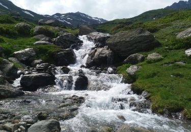
Très vite, à 2680m d'altitude, laisser le chemin et prendre à droite, dans le pierrier du Glacier du Bré en passant au travers de 2 ou 3 gués.
Retomber alors sur le chemin #15 à 2580m prendre le chemin à la descente (pour les motivés, il est possible de monter au Ricovero Florio /- 250m).
Descendre le chemin #15 puis #14B (2494m), puis monter au Ricovero du Capitaine Ricci (2668m). Redescendre alors le flan ouest du Plan Tsampigny. puis à 2412m tourner à droite en direction du Lago San Grato (2463m) via le chemin 14B puis 14A. en repartir par le chemin #14.
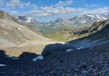
descendre au pont (2197m) puis à 2174m prendre à droite le chemin #13 en direction du col du Mont (2639m) synonyme de passage de la frontière Italie - France.
Descendre alors jusqu'au refuge de l'Archeboc.
Ort
Kommentare
Touren in der Umgebung
![Tour Zu Fuß Valgrisenche - Alta Via n. 2 della Valle d'Aosta - Tappa 6 - Photo](https://media.geolcdn.com/t/375/260/bbd52fff-ba6a-4ea9-8d5e-0a7cfafde77a.jpeg&format=jpg&maxdim=2)
![Zu Fuß Zu Fuß](https://static1.geolcdn.com/sitytour/trail-icons/100.png)
Zu Fuß
![](/images/other/stat-length.png)
![](https://static1.geolcdn.com/siteimages/upload/files/16400158638029165_repeat_loop_refresh_sync_direction_icon.png)
![Tour Zu Fuß Valgrisenche - (SI F03) Rifugio Chalet de l'Epée - Planaval - Photo](https://media.geolcdn.com/t/375/260/d0d9b39f-0875-4fe1-8e1d-ef35e0e56836.jpeg&format=jpg&maxdim=2)
![Zu Fuß Zu Fuß](https://static1.geolcdn.com/sitytour/trail-icons/100.png)
Zu Fuß
![](/images/other/stat-length.png)
![](https://static1.geolcdn.com/siteimages/upload/files/16400158638029165_repeat_loop_refresh_sync_direction_icon.png)
![Tour Zu Fuß Valgrisenche - 16, Rif. degli Angeli Dall'Arp Vieille - Photo](https://media.geolcdn.com/t/375/260/4913c606-4327-4a69-971a-a759c874efab.jpeg&format=jpg&maxdim=2)
![Zu Fuß Zu Fuß](https://static1.geolcdn.com/sitytour/trail-icons/100.png)
Zu Fuß
![](/images/other/stat-length.png)
![](https://static1.geolcdn.com/siteimages/upload/files/16400158638029165_repeat_loop_refresh_sync_direction_icon.png)
![Tour Wandern Valgrisenche - 180720 aoste . valgrisenche bonne . meillares .A-R - Photo](https://media.geolcdn.com/t/375/260/ext.jpg?maxdim=2&url=https%3A%2F%2Fservices.sitytrail.com%2FGeolivesWS%2FDownloadMedia.ashx%3FTrailID%3D1007423%26Media%3Dfix__20180720155450.jpg)
![Wandern Wandern](https://static1.geolcdn.com/sitytour/trail-icons/101.png)
Wandern
![](/images/other/stat-length.png)
![](https://static1.geolcdn.com/siteimages/upload/files/16400158638029165_repeat_loop_refresh_sync_direction_icon.png)
![Tour Wandern Valgrisenche - trace - Photo](https://media.geolcdn.com/t/375/260/ext.jpg?maxdim=2&url=https%3A%2F%2Fstatic1.geolcdn.com%2Fsiteimages%2Fupload%2Ffiles%2F1553511878bg_sport_marche.png)
![Wandern Wandern](https://static1.geolcdn.com/sitytour/trail-icons/101.png)
![Tour Wandern Valgrisenche - Étape 2 : Refuge Degli Angeli - Col du Mont - Refuge de l'Archeboc - Photo](https://media.geolcdn.com/t/375/260/bc9952e3-22e8-40c9-8314-60f52d0738b9.jpg&format=jpg&maxdim=2)
![Wandern Wandern](https://static1.geolcdn.com/sitytour/trail-icons/101.png)
Wandern
![](/images/other/stat-length.png)
![](https://static1.geolcdn.com/siteimages/upload/files/16400158638029165_repeat_loop_refresh_sync_direction_icon.png)
![Tour Zu Fuß Valgrisenche - 9A, Surrier Rifugio Chalet De L'Epée - Photo](https://media.geolcdn.com/t/375/260/ext.jpg?maxdim=2&url=https%3A%2F%2Fstatic1.geolcdn.com%2Fsiteimages%2Fupload%2Ffiles%2F1545311037marcheuse_200dpi.jpg)
![Zu Fuß Zu Fuß](https://static1.geolcdn.com/sitytour/trail-icons/100.png)
Zu Fuß
![](/images/other/stat-length.png)
![](https://static1.geolcdn.com/siteimages/upload/files/16400158638029165_repeat_loop_refresh_sync_direction_icon.png)
![Tour Wandern Valgrisenche - Rifugio Epee - Rhemes notre dame - Photo](https://media.geolcdn.com/t/375/260/b150fad9-57ef-4391-a160-61c532f01a59.jpg&format=jpg&maxdim=2)
![Wandern Wandern](https://static1.geolcdn.com/sitytour/trail-icons/101.png)
Wandern
![](/images/other/stat-length.png)
![](https://static1.geolcdn.com/siteimages/upload/files/16400158638029165_repeat_loop_refresh_sync_direction_icon.png)
![Tour Wandern Valgrisenche - Grand Paradis - J5 - Photo](https://media.geolcdn.com/t/375/260/ext.jpg?maxdim=2&url=https%3A%2F%2Fstatic1.geolcdn.com%2Fsiteimages%2Fupload%2Ffiles%2F1553511878bg_sport_marche.png)
![Wandern Wandern](https://static1.geolcdn.com/sitytour/trail-icons/101.png)
Wandern
![](/images/other/stat-length.png)
![](https://static1.geolcdn.com/siteimages/upload/files/16400158638029165_repeat_loop_refresh_sync_direction_icon.png)