![](/images/other/stat-length.png)
![Tour Wandern Ancelle - Le Piolt par la Pourrachiere 21/07/23 - Photo](https://media.geolcdn.com/t/1900/400/23f859ba-9c0c-41a5-8a5b-411ad6ec4ecc.jpg&format=pjpeg&maxdim=2)
Le Piolt par la Pourrachiere 21/07/23
R@ph
Benutzer GUIDE
![Länge](/images/other/stat-length.png)
Länge
13,7 km
![Maximale Höhe](https://static1.geolcdn.com/siteimages/upload/files/1508320355ic_sort_altitude_max_24dp.png)
Maximale Höhe
2434 m
![Positive Höhendifferenz](https://static1.geolcdn.com/siteimages/upload/files/1508320355ic_sort_den_pos_24dp.png)
Positive Höhendifferenz
855 m
![Km-Effort](/images/other/stat-length.png)
Km-Effort
25 km
![Min. Höhe](https://static1.geolcdn.com/siteimages/upload/files/1508320355ic_sort_altitude_min_24dp.png)
Min. Höhe
1620 m
![Negative Höhendifferenz](https://static1.geolcdn.com/siteimages/upload/files/1508320355ic_sort_den_neg_24dp.png)
Negative Höhendifferenz
854 m
![Boucle](https://static1.geolcdn.com/siteimages/upload/files/16400158638029165_repeat_loop_refresh_sync_direction_icon.png)
Boucle
Ja
Erstellungsdatum :
2023-07-22 07:15:45.356
Letzte Änderung :
2023-07-22 07:40:44.606
![Wandern](https://static1.geolcdn.com/sitytour/trail-icons/101.png)
5h41
Schwierigkeit : Sehr schwierig
![Scannen Sie diesen QR-Code, um die Tour in der SityTrail-Anwendung zu öffnen](https://capi.geolives.com/qq0zvz2zws4bq2lad0pu/sitytour/trails/3742862/qr.png?size=200)
Kostenlosegpshiking-Anwendung
Über SityTrail
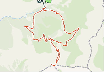
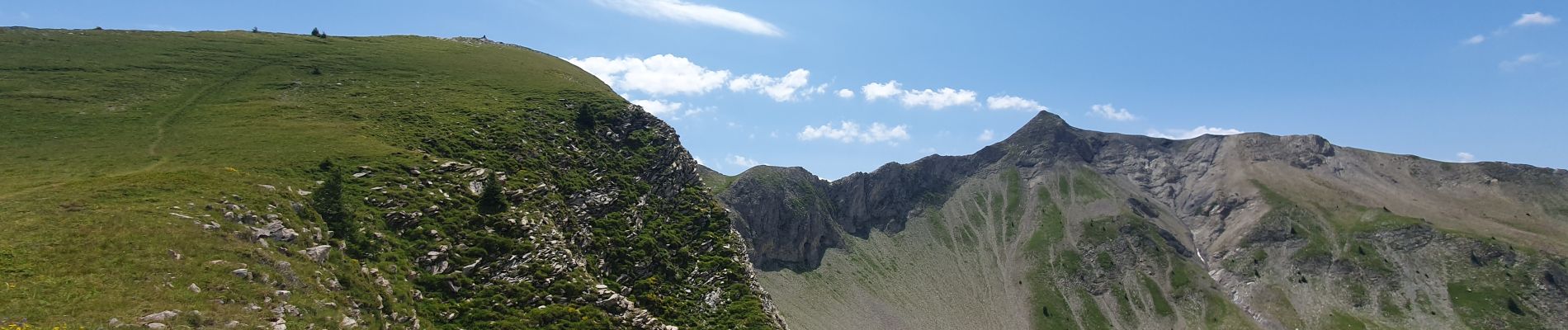
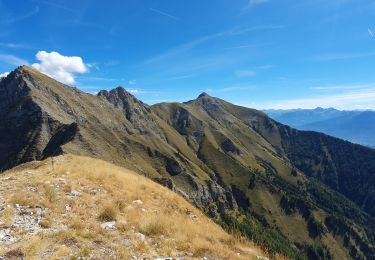
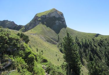
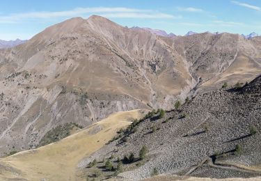
Tour Wandern von 13,7 km verfügbar auf Provence-Alpes-Côte d'Azur, Hochalpen, Ancelle. Diese Tour wird von R@ph vorgeschlagen.
Beschreibung
Départ du parking de Rouanne haute jusqu'au col de la Pourrachière, puis montée droit dans la pente par Bonnaparé jusqu'au sommet (le sentier est bien marqué). La descente jusqu'au col puis sur la gauche en passant par Serre la Grange.
Ort
Land:
France
Region :
Provence-Alpes-Côte d'Azur
Abteilung/Provinz :
Hochalpen
Kommune :
Ancelle
Standort:
Unknown
Gehen Sie:(Dec)
Gehen Sie:(UTM)
282894 ; 4945263 (32T) N.
Kommentare
Touren in der Umgebung
![Tour Wandern Saint-Jean-Saint-Nicolas - Circuit de Costebelle - Photo](https://media.geolcdn.com/t/375/260/ext.jpg?maxdim=2&url=https%3A%2F%2Fservices.sitytrail.com%2FGeolivesWS%2FDownloadMedia.ashx%3FTrailID%3D269960%26Media%3Dfix__20140424150455.jpg)
![Wandern Wandern](https://static1.geolcdn.com/sitytour/trail-icons/101.png)
Circuit de Costebelle
Wandern
Sehr leicht
(2)
Saint-Jean-Saint-Nicolas,
Provence-Alpes-Côte d'Azur,
Hochalpen,
France
![](/images/other/stat-length.png)
7,4 km | 12,1 km-effort
2h 16min
![](https://static1.geolcdn.com/siteimages/upload/files/16400158638029165_repeat_loop_refresh_sync_direction_icon.png)
Ja
![Tour Laufen Ancelle - Ancelle-Tour du Cuchon - Photo](https://media.geolcdn.com/t/375/260/ext.jpg?maxdim=2&url=https%3A%2F%2Fservices.sitytrail.com%2FGeolivesWS%2FDownloadMedia.ashx%3FTrailID%3D220701%26Media%3D20130912111439.jpg)
![Laufen Laufen](https://static1.geolcdn.com/sitytour/trail-icons/103.png)
Ancelle-Tour du Cuchon
Laufen
Sehr leicht
(2)
Ancelle,
Provence-Alpes-Côte d'Azur,
Hochalpen,
France
![](/images/other/stat-length.png)
15,4 km | 26 km-effort
3h 15min
![](https://static1.geolcdn.com/siteimages/upload/files/16400158638029165_repeat_loop_refresh_sync_direction_icon.png)
Ja
![Tour Wandern Ancelle - col de la coupa et tour de la rouanne - Photo](https://media.geolcdn.com/t/375/260/ext.jpg?maxdim=2&url=https%3A%2F%2Fservices.sitytrail.com%2FGeolivesWS%2FDownloadMedia.ashx%3FTrailID%3D344656%26Media%3Dfix__20140913132149.jpg)
![Wandern Wandern](https://static1.geolcdn.com/sitytour/trail-icons/101.png)
col de la coupa et tour de la rouanne
Wandern
Schwierig
(1)
Ancelle,
Provence-Alpes-Côte d'Azur,
Hochalpen,
France
![](/images/other/stat-length.png)
16,2 km | 28 km-effort
4h 56min
![](https://static1.geolcdn.com/siteimages/upload/files/16400158638029165_repeat_loop_refresh_sync_direction_icon.png)
Ja
![Tour Wandern Ancelle - L'arche et L'aiguille 01/09/23 - Photo](https://media.geolcdn.com/t/375/260/db1733c9-41d8-4b7e-9a2a-1b7dc4b88cc5.jpg&format=jpg&maxdim=2)
![Wandern Wandern](https://static1.geolcdn.com/sitytour/trail-icons/101.png)
L'arche et L'aiguille 01/09/23
Wandern
Sehr schwierig
Ancelle,
Provence-Alpes-Côte d'Azur,
Hochalpen,
France
![](/images/other/stat-length.png)
8,6 km | 19,6 km-effort
4h 27min
![](https://static1.geolcdn.com/siteimages/upload/files/16400158638029165_repeat_loop_refresh_sync_direction_icon.png)
Ja
![Tour Wandern Ancelle - suuntoapp-Hiking-2022-08-29T07-01-11Z - Photo](https://media.geolcdn.com/t/375/260/fcdbf62a-2363-464e-a0a9-f0f396108eb8.jpg&format=jpg&maxdim=2)
![Wandern Wandern](https://static1.geolcdn.com/sitytour/trail-icons/101.png)
suuntoapp-Hiking-2022-08-29T07-01-11Z
Wandern
Schwierig
Ancelle,
Provence-Alpes-Côte d'Azur,
Hochalpen,
France
![](/images/other/stat-length.png)
13,3 km | 25 km-effort
5h 0min
![](https://static1.geolcdn.com/siteimages/upload/files/16400158638029165_repeat_loop_refresh_sync_direction_icon.png)
Ja
![Tour Wandern Ancelle - Piolit - Photo](https://media.geolcdn.com/t/375/260/e3289fae-77ac-4123-96ec-1cf1fdd2bfc1.jpg&format=jpg&maxdim=2)
![Wandern Wandern](https://static1.geolcdn.com/sitytour/trail-icons/101.png)
Piolit
Wandern
Schwierig
Ancelle,
Provence-Alpes-Côte d'Azur,
Hochalpen,
France
![](/images/other/stat-length.png)
8,9 km | 19,4 km-effort
4h 24min
![](https://static1.geolcdn.com/siteimages/upload/files/16400158638029165_repeat_loop_refresh_sync_direction_icon.png)
Ja
![Tour Wandern Ancelle - Cuchon-Petite Autane - Photo](https://media.geolcdn.com/t/375/260/d578de73-ed95-44bf-af1d-1a65af80c427.jpg&format=jpg&maxdim=2)
![Wandern Wandern](https://static1.geolcdn.com/sitytour/trail-icons/101.png)
Cuchon-Petite Autane
Wandern
Sehr schwierig
Ancelle,
Provence-Alpes-Côte d'Azur,
Hochalpen,
France
![](/images/other/stat-length.png)
16 km | 30 km-effort
7h 0min
![](https://static1.geolcdn.com/siteimages/upload/files/16400158638029165_repeat_loop_refresh_sync_direction_icon.png)
Ja
![Wandern Wandern](https://static1.geolcdn.com/sitytour/trail-icons/101.png)
Arche
Wandern
Medium
Ancelle,
Provence-Alpes-Côte d'Azur,
Hochalpen,
France
![](/images/other/stat-length.png)
6,9 km | 16 km-effort
3h 37min
![](https://static1.geolcdn.com/siteimages/upload/files/16400158638029165_repeat_loop_refresh_sync_direction_icon.png)
Nein
![Tour Wandern Ancelle - Le Piolit par Rouanne Haute 27/09/19 - Photo](https://media.geolcdn.com/t/375/260/aa1c4c93-2e15-4452-8349-0daad3e3624f.jpg&format=jpg&maxdim=2)
![Wandern Wandern](https://static1.geolcdn.com/sitytour/trail-icons/101.png)
Le Piolit par Rouanne Haute 27/09/19
Wandern
Sehr schwierig
Ancelle,
Provence-Alpes-Côte d'Azur,
Hochalpen,
France
![](/images/other/stat-length.png)
14,2 km | 26 km-effort
5h 15min
![](https://static1.geolcdn.com/siteimages/upload/files/16400158638029165_repeat_loop_refresh_sync_direction_icon.png)
Ja