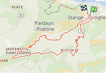
![](/images/other/stat-length.png)
![Tour Wandern Ratschings - Stange cascades retour par les ruines - Photo](https://media.geolcdn.com/t/1900/400/ext.pjpeg?maxdim=2&url=https%3A%2F%2Fstatic1.geolcdn.com%2Fsiteimages%2Fupload%2Ffiles%2F1553511878bg_sport_marche.png)
Stange cascades retour par les ruines
pidjam
Benutzer
![Länge](/images/other/stat-length.png)
Länge
6,2 km
![Maximale Höhe](https://static1.geolcdn.com/siteimages/upload/files/1508320355ic_sort_altitude_max_24dp.png)
Maximale Höhe
1278 m
![Positive Höhendifferenz](https://static1.geolcdn.com/siteimages/upload/files/1508320355ic_sort_den_pos_24dp.png)
Positive Höhendifferenz
326 m
![Km-Effort](/images/other/stat-length.png)
Km-Effort
10,5 km
![Min. Höhe](https://static1.geolcdn.com/siteimages/upload/files/1508320355ic_sort_altitude_min_24dp.png)
Min. Höhe
970 m
![Negative Höhendifferenz](https://static1.geolcdn.com/siteimages/upload/files/1508320355ic_sort_den_neg_24dp.png)
Negative Höhendifferenz
329 m
![Boucle](https://static1.geolcdn.com/siteimages/upload/files/16400158638029165_repeat_loop_refresh_sync_direction_icon.png)
Boucle
Ja
Erstellungsdatum :
2023-07-20 07:27:21.219
Letzte Änderung :
2023-08-03 15:19:17.507
![Wandern](https://static1.geolcdn.com/sitytour/trail-icons/101.png)
2h23
Schwierigkeit : Medium
![Scannen Sie diesen QR-Code, um die Tour in der SityTrail-Anwendung zu öffnen](https://capi.geolives.com/qq0zvz2zws4bq2lad0pu/sitytour/trails/3740841/qr.png?size=200)
Kostenlosegpshiking-Anwendung
Über SityTrail
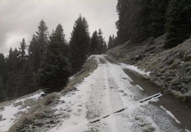
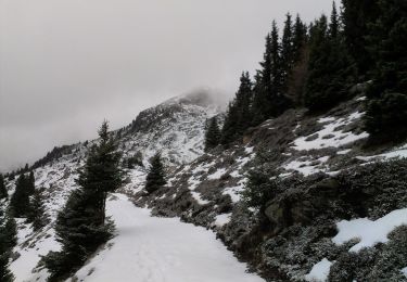
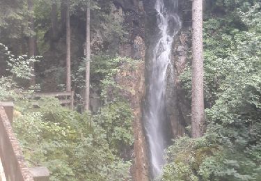
Tour Wandern von 6,2 km verfügbar auf Trentino-Südtirol, Bozen, Ratschings. Diese Tour wird von pidjam vorgeschlagen.
Beschreibung
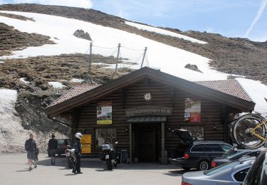
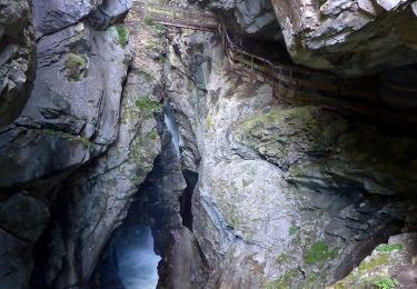
La montée dans les gorges est très belle (chemin payant) , avec la descente par le chemin "3" . Le point de départ est l'arrêt de bus (312 et 319).
Ort
Land:
Italy
Region :
Trentino-Südtirol
Abteilung/Provinz :
Bozen
Kommune :
Ratschings
Standort:
Unknown
Gehen Sie:(Dec)
Gehen Sie:(UTM)
681248 ; 5194822 (32T) N.
Kommentare
Touren in der Umgebung
![Tour Zu Fuß Ratschings - IT-5 - Photo](https://media.geolcdn.com/t/375/260/8d0a12d1-864c-44a5-8d33-04419321a951.jpeg&format=jpg&maxdim=2)
![Zu Fuß Zu Fuß](https://static1.geolcdn.com/sitytour/trail-icons/100.png)
![Tour Zu Fuß Ratschings - IT-11A - Photo](https://media.geolcdn.com/t/375/260/2ebe03cf-d747-42fc-a753-2718c3287185.jpeg&format=jpg&maxdim=2)
![Zu Fuß Zu Fuß](https://static1.geolcdn.com/sitytour/trail-icons/100.png)
IT-11A
Zu Fuß
Einfach
Ratschings,
Trentino-Südtirol,
Bozen,
Italy
![](/images/other/stat-length.png)
4,3 km | 5,7 km-effort
1h 18min
![](https://static1.geolcdn.com/siteimages/upload/files/16400158638029165_repeat_loop_refresh_sync_direction_icon.png)
Nein
![Tour Zu Fuß Freienfeld - IT-2 - Photo](https://media.geolcdn.com/t/375/260/9174566e-0bb2-4d00-98a1-ab8775d1c3cc.jpeg&format=jpg&maxdim=2)
![Zu Fuß Zu Fuß](https://static1.geolcdn.com/sitytour/trail-icons/100.png)
IT-2
Zu Fuß
Einfach
Freienfeld,
Trentino-Südtirol,
Bozen,
Italy
![](/images/other/stat-length.png)
4,3 km | 5,2 km-effort
1h 10min
![](https://static1.geolcdn.com/siteimages/upload/files/16400158638029165_repeat_loop_refresh_sync_direction_icon.png)
Nein
![Tour Zu Fuß Ratschings - IT-17A - Photo](https://media.geolcdn.com/t/375/260/8f2b9ffd-9076-42e9-bee7-887cb509d021.jpeg&format=jpg&maxdim=2)
![Zu Fuß Zu Fuß](https://static1.geolcdn.com/sitytour/trail-icons/100.png)
IT-17A
Zu Fuß
Einfach
Ratschings,
Trentino-Südtirol,
Bozen,
Italy
![](/images/other/stat-length.png)
4,2 km | 8 km-effort
1h 48min
![](https://static1.geolcdn.com/siteimages/upload/files/16400158638029165_repeat_loop_refresh_sync_direction_icon.png)
Nein
![Tour Zu Fuß Ratschings - IT-17B - Photo](https://media.geolcdn.com/t/375/260/954ae08a-e0c4-4fc7-ac6d-a4ba490afbcb.jpeg&format=jpg&maxdim=2)
![Zu Fuß Zu Fuß](https://static1.geolcdn.com/sitytour/trail-icons/100.png)
IT-17B
Zu Fuß
Einfach
Ratschings,
Trentino-Südtirol,
Bozen,
Italy
![](/images/other/stat-length.png)
6,3 km | 15 km-effort
3h 24min
![](https://static1.geolcdn.com/siteimages/upload/files/16400158638029165_repeat_loop_refresh_sync_direction_icon.png)
Nein
![Tour Zu Fuß Sterzing - IT-23 - Photo](https://media.geolcdn.com/t/375/260/2eaccf5a-b73a-4521-9800-c0169a311368.jpeg&format=jpg&maxdim=2)
![Zu Fuß Zu Fuß](https://static1.geolcdn.com/sitytour/trail-icons/100.png)
![Tour Zu Fuß Ratschings - IT-25 - Photo](https://media.geolcdn.com/t/375/260/b43e72a5-1912-4e16-8ebd-2f1408822a04.jpeg&format=jpg&maxdim=2)
![Zu Fuß Zu Fuß](https://static1.geolcdn.com/sitytour/trail-icons/100.png)
IT-25
Zu Fuß
Einfach
Ratschings,
Trentino-Südtirol,
Bozen,
Italy
![](/images/other/stat-length.png)
3,9 km | 11,9 km-effort
2h 42min
![](https://static1.geolcdn.com/siteimages/upload/files/16400158638029165_repeat_loop_refresh_sync_direction_icon.png)
Nein
![Tour Zu Fuß Sterzing - Ridnauner Höhenweg - Photo](https://media.geolcdn.com/t/375/260/653c9afc-7c5f-4fe5-a5db-51813c6da7cd.jpeg&format=jpg&maxdim=2)
![Zu Fuß Zu Fuß](https://static1.geolcdn.com/sitytour/trail-icons/100.png)
Ridnauner Höhenweg
Zu Fuß
Medium
Sterzing,
Trentino-Südtirol,
Bozen,
Italy
![](/images/other/stat-length.png)
12 km | 22 km-effort
4h 56min
![](https://static1.geolcdn.com/siteimages/upload/files/16400158638029165_repeat_loop_refresh_sync_direction_icon.png)
Nein
![Tour Wandern Ratschings - Gilfenklamm - Photo](https://media.geolcdn.com/t/375/260/ext.jpg?maxdim=2&url=https%3A%2F%2Fservices.sitytrail.com%2FGeolivesWS%2FDownloadMedia.ashx%3FTrailID%3D795366%26Media%3Dfix__20170724122516.jpg)
![Wandern Wandern](https://static1.geolcdn.com/sitytour/trail-icons/101.png)
Gilfenklamm
Wandern
Einfach
(1)
Ratschings,
Trentino-Südtirol,
Bozen,
Italy
![](/images/other/stat-length.png)
5,9 km | 8,7 km-effort
2h 19min
![](https://static1.geolcdn.com/siteimages/upload/files/16400158638029165_repeat_loop_refresh_sync_direction_icon.png)
Ja