![](/images/other/stat-length.png)
![Tour Wandern Allos - Mont Pelat - Photo](https://media.geolcdn.com/t/1900/400/ext.pjpeg?maxdim=2&url=https%3A%2F%2Fstatic1.geolcdn.com%2Fsiteimages%2Fupload%2Ffiles%2F1553511878bg_sport_marche.png)
Mont Pelat
GAPIAN43
Benutzer
![Länge](/images/other/stat-length.png)
Länge
13,7 km
![Maximale Höhe](https://static1.geolcdn.com/siteimages/upload/files/1508320355ic_sort_altitude_max_24dp.png)
Maximale Höhe
3008 m
![Positive Höhendifferenz](https://static1.geolcdn.com/siteimages/upload/files/1508320355ic_sort_den_pos_24dp.png)
Positive Höhendifferenz
904 m
![Km-Effort](/images/other/stat-length.png)
Km-Effort
26 km
![Min. Höhe](https://static1.geolcdn.com/siteimages/upload/files/1508320355ic_sort_altitude_min_24dp.png)
Min. Höhe
2113 m
![Negative Höhendifferenz](https://static1.geolcdn.com/siteimages/upload/files/1508320355ic_sort_den_neg_24dp.png)
Negative Höhendifferenz
904 m
![Boucle](https://static1.geolcdn.com/siteimages/upload/files/16400158638029165_repeat_loop_refresh_sync_direction_icon.png)
Boucle
Ja
Erstellungsdatum :
2023-07-20 08:46:34.37
Letzte Änderung :
2023-07-20 09:01:29.992
![Wandern](https://static1.geolcdn.com/sitytour/trail-icons/101.png)
5h50
Schwierigkeit : Sehr schwierig
![Scannen Sie diesen QR-Code, um die Tour in der SityTrail-Anwendung zu öffnen](https://capi.geolives.com/qq0zvz2zws4bq2lad0pu/sitytour/trails/3740758/qr.png?size=200)
Kostenlosegpshiking-Anwendung
Über SityTrail
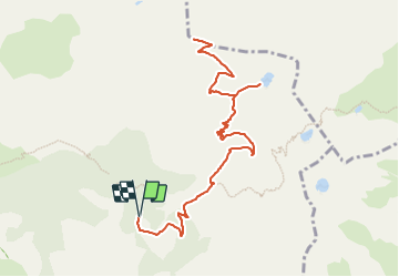
Tour Wandern von 13,7 km verfügbar auf Provence-Alpes-Côte d'Azur, Alpes-de-Haute-Provence, Allos. Diese Tour wird von GAPIAN43 vorgeschlagen.
Beschreibung
Réputé comme le 3000 le plus facile des Alpes du Sud. Il domine au Nord le site glaciaire du Lac d'Allos, le plus grand lac d'altitude d'Europe situé à 2227 mètres.
Ort
Land:
France
Region :
Provence-Alpes-Côte d'Azur
Abteilung/Provinz :
Alpes-de-Haute-Provence
Kommune :
Allos
Standort:
Unknown
Gehen Sie:(Dec)
Gehen Sie:(UTM)
316182 ; 4901655 (32T) N.
Kommentare
Touren in der Umgebung
![Tour Wandern Uvernet-Fours - Mercantour Le Cimet 3020 m - Photo](https://media.geolcdn.com/t/375/260/ext.jpg?maxdim=2&url=https%3A%2F%2Fservices.sitytrail.com%2FGeolivesWS%2FDownloadMedia.ashx%3FTrailID%3D224622%26Media%3D20130930134741.jpg)
![Wandern Wandern](https://static1.geolcdn.com/sitytour/trail-icons/101.png)
Mercantour Le Cimet 3020 m
Wandern
Medium
(2)
Uvernet-Fours,
Provence-Alpes-Côte d'Azur,
Alpes-de-Haute-Provence,
France
![](/images/other/stat-length.png)
20 km | 34 km-effort
5h 49min
![](https://static1.geolcdn.com/siteimages/upload/files/16400158638029165_repeat_loop_refresh_sync_direction_icon.png)
Ja
![Wandern Wandern](https://static1.geolcdn.com/sitytour/trail-icons/101.png)
Mont Pelat par la grande barre
Wandern
Schwierig
(1)
Uvernet-Fours,
Provence-Alpes-Côte d'Azur,
Alpes-de-Haute-Provence,
France
![](/images/other/stat-length.png)
16,4 km | 34 km-effort
4h 0min
![](https://static1.geolcdn.com/siteimages/upload/files/16400158638029165_repeat_loop_refresh_sync_direction_icon.png)
Ja
![Tour Wandern Allos - ALLOS. LAC D ALLOS. COL DE LACAYOLE .O - Photo](https://media.geolcdn.com/t/375/260/dff6c4e7-81d7-4f55-8309-f016e1c29cdc.jpg&format=jpg&maxdim=2)
![Wandern Wandern](https://static1.geolcdn.com/sitytour/trail-icons/101.png)
ALLOS. LAC D ALLOS. COL DE LACAYOLE .O
Wandern
Medium
Allos,
Provence-Alpes-Côte d'Azur,
Alpes-de-Haute-Provence,
France
![](/images/other/stat-length.png)
12,1 km | 19,7 km-effort
3h 39min
![](https://static1.geolcdn.com/siteimages/upload/files/16400158638029165_repeat_loop_refresh_sync_direction_icon.png)
Nein
![Wandern Wandern](https://static1.geolcdn.com/sitytour/trail-icons/101.png)
Cimet
Wandern
Schwierig
Uvernet-Fours,
Provence-Alpes-Côte d'Azur,
Alpes-de-Haute-Provence,
France
![](/images/other/stat-length.png)
13,6 km | 27 km-effort
6h 10min
![](https://static1.geolcdn.com/siteimages/upload/files/16400158638029165_repeat_loop_refresh_sync_direction_icon.png)
Ja
![Tour Zu Fuß Entraunes - Circuit des Lacs - Photo](https://media.geolcdn.com/t/375/260/a896acce-5a5d-4d38-a76c-8521eb37107d.jpeg&format=jpg&maxdim=2)
![Zu Fuß Zu Fuß](https://static1.geolcdn.com/sitytour/trail-icons/100.png)
Circuit des Lacs
Zu Fuß
Einfach
Entraunes,
Provence-Alpes-Côte d'Azur,
Seealpen,
France
![](/images/other/stat-length.png)
8,9 km | 14,7 km-effort
3h 21min
![](https://static1.geolcdn.com/siteimages/upload/files/16400158638029165_repeat_loop_refresh_sync_direction_icon.png)
Ja
![Tour Zu Fuß Entraunes - Col de la Boucharde - Photo](https://media.geolcdn.com/t/375/260/3f8fb4f1-6b5f-4291-a48f-766ff65dc022.jpeg&format=jpg&maxdim=2)
![Zu Fuß Zu Fuß](https://static1.geolcdn.com/sitytour/trail-icons/100.png)
Col de la Boucharde
Zu Fuß
Medium
Entraunes,
Provence-Alpes-Côte d'Azur,
Seealpen,
France
![](/images/other/stat-length.png)
16,6 km | 29 km-effort
6h 33min
![](https://static1.geolcdn.com/siteimages/upload/files/16400158638029165_repeat_loop_refresh_sync_direction_icon.png)
Ja
![Tour Zu Fuß Entraunes - Tête de la Boulière - Photo](https://media.geolcdn.com/t/375/260/4b7ce69a-b9c1-4af6-a119-2b6bf9e9add8.jpeg&format=jpg&maxdim=2)
![Zu Fuß Zu Fuß](https://static1.geolcdn.com/sitytour/trail-icons/100.png)
Tête de la Boulière
Zu Fuß
Medium
Entraunes,
Provence-Alpes-Côte d'Azur,
Seealpen,
France
![](/images/other/stat-length.png)
16,9 km | 29 km-effort
6h 41min
![](https://static1.geolcdn.com/siteimages/upload/files/16400158638029165_repeat_loop_refresh_sync_direction_icon.png)
Ja
![Tour Wandern Allos - le mont Pelat et le lac du trou de l'aigle - Photo](https://media.geolcdn.com/t/375/260/ext.jpg?maxdim=2&url=https%3A%2F%2Fservices.sitytrail.com%2FGeolivesWS%2FDownloadMedia.ashx%3FTrailID%3D791325%26Media%3D36a05fdf-444e-4dea-af98-fa2a609b54f1.JPG)
![Wandern Wandern](https://static1.geolcdn.com/sitytour/trail-icons/101.png)
le mont Pelat et le lac du trou de l'aigle
Wandern
Medium
Allos,
Provence-Alpes-Côte d'Azur,
Alpes-de-Haute-Provence,
France
![](/images/other/stat-length.png)
14,4 km | 27 km-effort
7h 19min
![](https://static1.geolcdn.com/siteimages/upload/files/16400158638029165_repeat_loop_refresh_sync_direction_icon.png)
Ja
![Tour Zu Fuß Uvernet-Fours - Circuit des lacs, 04-09-2024 - Photo](https://media.geolcdn.com/t/375/260/09012fd6-d42d-4279-856d-5992e350195b.jpg&format=jpg&maxdim=2)
![Zu Fuß Zu Fuß](https://static1.geolcdn.com/sitytour/trail-icons/100.png)
Circuit des lacs, 04-09-2024
Zu Fuß
Medium
Uvernet-Fours,
Provence-Alpes-Côte d'Azur,
Alpes-de-Haute-Provence,
France
![](/images/other/stat-length.png)
9,1 km | 15,2 km-effort
3h 27min
![](https://static1.geolcdn.com/siteimages/upload/files/16400158638029165_repeat_loop_refresh_sync_direction_icon.png)
Ja