![](/images/other/stat-length.png)
![Tour Wandern Val-de-Reuil - EURE ET SEINE DU VAL DE RUEIL A POSES BOUCLE - Photo](https://media.geolcdn.com/t/1900/400/ext.pjpeg?maxdim=2&url=https%3A%2F%2Fstatic1.geolcdn.com%2Fsiteimages%2Fupload%2Ffiles%2F1553511878bg_sport_marche.png)
EURE ET SEINE DU VAL DE RUEIL A POSES BOUCLE
les randos d'Olivier
partout a pied et en moto
![Länge](/images/other/stat-length.png)
Länge
18,6 km
![Maximale Höhe](https://static1.geolcdn.com/siteimages/upload/files/1508320355ic_sort_altitude_max_24dp.png)
Maximale Höhe
17 m
![Positive Höhendifferenz](https://static1.geolcdn.com/siteimages/upload/files/1508320355ic_sort_den_pos_24dp.png)
Positive Höhendifferenz
94 m
![Km-Effort](/images/other/stat-length.png)
Km-Effort
19,8 km
![Min. Höhe](https://static1.geolcdn.com/siteimages/upload/files/1508320355ic_sort_altitude_min_24dp.png)
Min. Höhe
1 m
![Negative Höhendifferenz](https://static1.geolcdn.com/siteimages/upload/files/1508320355ic_sort_den_neg_24dp.png)
Negative Höhendifferenz
94 m
![Boucle](https://static1.geolcdn.com/siteimages/upload/files/16400158638029165_repeat_loop_refresh_sync_direction_icon.png)
Boucle
Ja
Erstellungsdatum :
2023-07-13 09:05:58.632
Letzte Änderung :
2023-07-14 15:24:22.985
![Wandern](https://static1.geolcdn.com/sitytour/trail-icons/101.png)
4h30
Schwierigkeit : Sehr schwierig
![Scannen Sie diesen QR-Code, um die Tour in der SityTrail-Anwendung zu öffnen](https://capi.geolives.com/qq0zvz2zws4bq2lad0pu/sitytour/trails/3732038/qr.png?size=200)
Kostenlosegpshiking-Anwendung
Über SityTrail
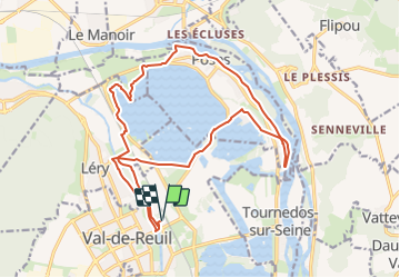
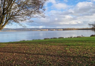
Tour Wandern von 18,6 km verfügbar auf Normandie, Eure, Val-de-Reuil. Diese Tour wird von les randos d'Olivier vorgeschlagen.
Beschreibung
ENTRE DEUX VALLEES , DE L'EURE ET DE LA SEINE, LE LAC DES DEUX AMANTS ET LES BORDS DE SEINE PARADISIAQUES DE POSES, BOUCLE AU DEPART DE LA GARE DE VAL DE REUIL
Ort
Land:
France
Region :
Normandie
Abteilung/Provinz :
Eure
Kommune :
Val-de-Reuil
Standort:
Unknown
Gehen Sie:(Dec)
Gehen Sie:(UTM)
370825 ; 5459572 (31U) N.
Kommentare
Touren in der Umgebung
![Tour Pfad Les Damps - 20190820_135035 - Photo](https://media.geolcdn.com/t/375/260/ext.jpg?maxdim=2&url=https%3A%2F%2Fstatic1.geolcdn.com%2Fsiteimages%2Fupload%2Ffiles%2F1524743154running.jpg)
![Pfad Pfad](https://static1.geolcdn.com/sitytour/trail-icons/104.png)
20190820_135035
Pfad
Sehr leicht
(1)
Les Damps,
Normandie,
Eure,
France
![](/images/other/stat-length.png)
10,9 km | 12,5 km-effort
Unbekannt
![](https://static1.geolcdn.com/siteimages/upload/files/16400158638029165_repeat_loop_refresh_sync_direction_icon.png)
Ja
![Tour Wandern Pont-de-l'Arche - Pont de l'Arche/ Les Damps (126) - Photo](https://media.geolcdn.com/t/375/260/ext.jpg?maxdim=2&url=https%3A%2F%2Fstatic1.geolcdn.com%2Fsiteimages%2Fupload%2Ffiles%2F1553511878bg_sport_marche.png)
![Wandern Wandern](https://static1.geolcdn.com/sitytour/trail-icons/101.png)
Pont de l'Arche/ Les Damps (126)
Wandern
Medium
(4)
Pont-de-l'Arche,
Normandie,
Eure,
France
![](/images/other/stat-length.png)
11,5 km | 13,9 km-effort
3h 3min
![](https://static1.geolcdn.com/siteimages/upload/files/16400158638029165_repeat_loop_refresh_sync_direction_icon.png)
Ja
![Tour Wandern Amfreville-sous-les-Monts - Côte des Deux amants (107) - Photo](https://media.geolcdn.com/t/375/260/ext.jpg?maxdim=2&url=https%3A%2F%2Fstatic1.geolcdn.com%2Fsiteimages%2Fupload%2Ffiles%2F1553511878bg_sport_marche.png)
![Wandern Wandern](https://static1.geolcdn.com/sitytour/trail-icons/101.png)
Côte des Deux amants (107)
Wandern
Sehr schwierig
(1)
Amfreville-sous-les-Monts,
Normandie,
Eure,
France
![](/images/other/stat-length.png)
8,4 km | 12 km-effort
2h 32min
![](https://static1.geolcdn.com/siteimages/upload/files/16400158638029165_repeat_loop_refresh_sync_direction_icon.png)
Ja
![Tour Wandern Herqueville - Daniel - Photo](https://media.geolcdn.com/t/375/260/ext.jpg?maxdim=2&url=https%3A%2F%2Fstatic1.geolcdn.com%2Fsiteimages%2Fupload%2Ffiles%2F1553511878bg_sport_marche.png)
![Wandern Wandern](https://static1.geolcdn.com/sitytour/trail-icons/101.png)
Daniel
Wandern
Sehr leicht
(2)
Herqueville,
Normandie,
Eure,
France
![](/images/other/stat-length.png)
9,8 km | 11,2 km-effort
2h 40min
![](https://static1.geolcdn.com/siteimages/upload/files/16400158638029165_repeat_loop_refresh_sync_direction_icon.png)
Ja
![Tour Wandern Saint-Pierre-du-Vauvray - Saint-Pierre-du-Vauvray - Les côtes de Vauvray - Photo](https://media.geolcdn.com/t/375/260/ext.jpg?maxdim=2&url=https%3A%2F%2Fstatic1.geolcdn.com%2Fsiteimages%2Fupload%2Ffiles%2F1553511878bg_sport_marche.png)
![Wandern Wandern](https://static1.geolcdn.com/sitytour/trail-icons/101.png)
Saint-Pierre-du-Vauvray - Les côtes de Vauvray
Wandern
Medium
(1)
Saint-Pierre-du-Vauvray,
Normandie,
Eure,
France
![](/images/other/stat-length.png)
10,7 km | 13,8 km-effort
2h 57min
![](https://static1.geolcdn.com/siteimages/upload/files/16400158638029165_repeat_loop_refresh_sync_direction_icon.png)
Ja
![Tour sport Le Vaudreuil - Du Vaudreuil, aux Andelys et retour - Photo](https://media.geolcdn.com/t/375/260/20c8ffda-31e3-4118-abb6-292e764a0bf3.jpg&format=jpg&maxdim=2)
Du Vaudreuil, aux Andelys et retour
sport
Sehr leicht
Le Vaudreuil,
Normandie,
Eure,
France
![](/images/other/stat-length.png)
58 km | 64 km-effort
Unbekannt
![](https://static1.geolcdn.com/siteimages/upload/files/16400158638029165_repeat_loop_refresh_sync_direction_icon.png)
Ja
![Wandern Wandern](https://static1.geolcdn.com/sitytour/trail-icons/101.png)
20240227-Poses
Wandern
Einfach
Amfreville-sous-les-Monts,
Normandie,
Eure,
France
![](/images/other/stat-length.png)
13,1 km | 14,1 km-effort
2h 49min
![](https://static1.geolcdn.com/siteimages/upload/files/16400158638029165_repeat_loop_refresh_sync_direction_icon.png)
Ja
![Tour Wandern Saint-Pierre-du-Vauvray - 20240215-St Pierre du Vauvray - Photo](https://media.geolcdn.com/t/375/260/02c016ec-c185-4c3d-8524-4a9998bc8ab6.jpg&format=jpg&maxdim=2)
![Wandern Wandern](https://static1.geolcdn.com/sitytour/trail-icons/101.png)
20240215-St Pierre du Vauvray
Wandern
Medium
Saint-Pierre-du-Vauvray,
Normandie,
Eure,
France
![](/images/other/stat-length.png)
12,8 km | 15,6 km-effort
3h 2min
![](https://static1.geolcdn.com/siteimages/upload/files/16400158638029165_repeat_loop_refresh_sync_direction_icon.png)
Ja
![Tour Wandern Les Damps - 20231212-Les Damps - Photo](https://media.geolcdn.com/t/375/260/9b98702f-b952-4d47-95e5-e5dc435553fd.jpg&format=jpg&maxdim=2)
![Wandern Wandern](https://static1.geolcdn.com/sitytour/trail-icons/101.png)
20231212-Les Damps
Wandern
Medium
Les Damps,
Normandie,
Eure,
France
![](/images/other/stat-length.png)
9,5 km | 11,1 km-effort
2h 39min
![](https://static1.geolcdn.com/siteimages/upload/files/16400158638029165_repeat_loop_refresh_sync_direction_icon.png)
Ja