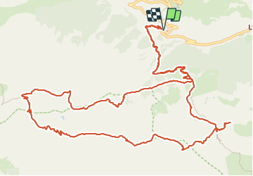
![](/images/other/stat-length.png)
![Tour Wandern Saint-Dalmas-le-Selvage - Crête de la Blanche - Photo](https://media.geolcdn.com/t/1900/400/49af8a69-1f1b-4aa1-9daa-e49ddac3cd6c.jpg&format=pjpeg&maxdim=2)
Crête de la Blanche
GuyVachet
Benutzer
![Länge](/images/other/stat-length.png)
![Maximale Höhe](https://static1.geolcdn.com/siteimages/upload/files/1508320355ic_sort_altitude_max_24dp.png)
![Positive Höhendifferenz](https://static1.geolcdn.com/siteimages/upload/files/1508320355ic_sort_den_pos_24dp.png)
![Km-Effort](/images/other/stat-length.png)
![Min. Höhe](https://static1.geolcdn.com/siteimages/upload/files/1508320355ic_sort_altitude_min_24dp.png)
![Negative Höhendifferenz](https://static1.geolcdn.com/siteimages/upload/files/1508320355ic_sort_den_neg_24dp.png)
![Boucle](https://static1.geolcdn.com/siteimages/upload/files/16400158638029165_repeat_loop_refresh_sync_direction_icon.png)
![Wandern](https://static1.geolcdn.com/sitytour/trail-icons/101.png)
7h21
Schwierigkeit : Sehr schwierig
![Scannen Sie diesen QR-Code, um die Tour in der SityTrail-Anwendung zu öffnen](https://capi.geolives.com/qq0zvz2zws4bq2lad0pu/sitytour/trails/3726014/qr.png?size=200)
Kostenlosegpshiking-Anwendung
Über SityTrail
Tour Wandern von 18,2 km verfügbar auf Provence-Alpes-Côte d'Azur, Seealpen, Saint-Dalmas-le-Selvage. Diese Tour wird von GuyVachet vorgeschlagen.
Beschreibung
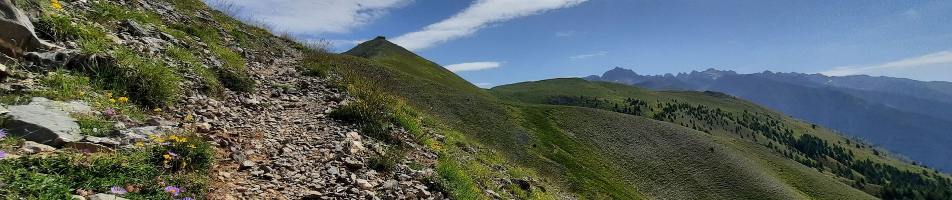
Très beau parcours en boucle pour parcourir cette crête entre les cols de la Colombière et de Colombart au départ de Bousiéyas. Le début de l'itinéraire est un large sentier et au Col de la Colombière, il faut quitter le GR5 (extension possible pour la Tête de Vinaigre) pour passer sous la Pointe Giassin. Le sentier étroit et la pente peuvent impressionner mais passe bien dans ce sens. Une fois la crête atteinte, le panorama se révèle et la suite est variée et sans difficulté. Le Col de l'Alpe est le point haut du parcours à partir duquel la descente commence. Au niveau de Lauzarouotte, on retrouve le chemin du début pour rejoindre Bousiéyas.
Ort
Kommentare
Touren in der Umgebung
![Tour Wandern Saint-Étienne-de-Tinée - Les Praz lacs de morgon pas de morgon col de fer - Photo](https://media.geolcdn.com/t/375/260/b305c453-9657-41de-ab22-a223a802df42.jpg&format=jpg&maxdim=2)
![Wandern Wandern](https://static1.geolcdn.com/sitytour/trail-icons/101.png)
Wandern
![](/images/other/stat-length.png)
![](https://static1.geolcdn.com/siteimages/upload/files/16400158638029165_repeat_loop_refresh_sync_direction_icon.png)
![Tour Wandern Saint-Étienne-de-Tinée - Refuge de Vens par le Col du Fer - Photo](https://media.geolcdn.com/t/375/260/07f7f5f4-c466-4163-95bf-638647005431.jpg&format=jpg&maxdim=2)
![Wandern Wandern](https://static1.geolcdn.com/sitytour/trail-icons/101.png)
Wandern
![](/images/other/stat-length.png)
![](https://static1.geolcdn.com/siteimages/upload/files/16400158638029165_repeat_loop_refresh_sync_direction_icon.png)
![Tour Wandern Saint-Étienne-de-Tinée - Reel Col du Fer lac refuge de Vens Cabane de Tortisse - Photo](https://media.geolcdn.com/t/375/260/43a881a4-8325-4e36-a280-d71b36c99c78.jpg&format=jpg&maxdim=2)
![Wandern Wandern](https://static1.geolcdn.com/sitytour/trail-icons/101.png)
Wandern
![](/images/other/stat-length.png)
![](https://static1.geolcdn.com/siteimages/upload/files/16400158638029165_repeat_loop_refresh_sync_direction_icon.png)
![Tour Zu Fuß Saint-Dalmas-le-Selvage - Crête de la Blanche - Photo](https://media.geolcdn.com/t/375/260/8fef9bcd-e2c1-4a5f-8511-8141c69ceadb.jpeg&format=jpg&maxdim=2)
![Zu Fuß Zu Fuß](https://static1.geolcdn.com/sitytour/trail-icons/100.png)
Zu Fuß
![](/images/other/stat-length.png)
![](https://static1.geolcdn.com/siteimages/upload/files/16400158638029165_repeat_loop_refresh_sync_direction_icon.png)
![Tour Zu Fuß Saint-Étienne-de-Tinée - Chemin de l'Energie - Photo](https://media.geolcdn.com/t/375/260/45dc2ef9-a27b-439a-8012-c03ab217c2f9.jpeg&format=jpg&maxdim=2)
![Zu Fuß Zu Fuß](https://static1.geolcdn.com/sitytour/trail-icons/100.png)
Zu Fuß
![](/images/other/stat-length.png)
![](https://static1.geolcdn.com/siteimages/upload/files/16400158638029165_repeat_loop_refresh_sync_direction_icon.png)
![Tour Zu Fuß Saint-Étienne-de-Tinée - Chemin de l'Energie - Etape 1 - Photo](https://media.geolcdn.com/t/375/260/0794a3d0-3fdc-40ed-a80f-245b620bf282.jpeg&format=jpg&maxdim=2)
![Zu Fuß Zu Fuß](https://static1.geolcdn.com/sitytour/trail-icons/100.png)
Zu Fuß
![](/images/other/stat-length.png)
![](https://static1.geolcdn.com/siteimages/upload/files/16400158638029165_repeat_loop_refresh_sync_direction_icon.png)
![Tour Wandern Saint-Dalmas-le-Selvage - crete de la blanche (sens inverse des aiguilles de la montre) - Photo](https://media.geolcdn.com/t/375/260/8277ee34-7f4f-4605-8ad8-3f70e64ea507.jpg&format=jpg&maxdim=2)
![Wandern Wandern](https://static1.geolcdn.com/sitytour/trail-icons/101.png)
Wandern
![](/images/other/stat-length.png)
![](https://static1.geolcdn.com/siteimages/upload/files/16400158638029165_repeat_loop_refresh_sync_direction_icon.png)
![Tour Skiwanderen Saint-Dalmas-le-Selvage - tentative de la crête de carpasse, et la croix de carlet - Photo](https://media.geolcdn.com/t/375/260/1fd4df26-1c9e-4eb6-8b35-62f8038fd665.jpg&format=jpg&maxdim=2)
![Skiwanderen Skiwanderen](https://static1.geolcdn.com/sitytour/trail-icons/503.png)
Skiwanderen
![](/images/other/stat-length.png)
![](https://static1.geolcdn.com/siteimages/upload/files/16400158638029165_repeat_loop_refresh_sync_direction_icon.png)
![Wandern Wandern](https://static1.geolcdn.com/sitytour/trail-icons/101.png)
Wandern
![](/images/other/stat-length.png)
![](https://static1.geolcdn.com/siteimages/upload/files/16400158638029165_repeat_loop_refresh_sync_direction_icon.png)