![](/images/other/stat-length.png)
![Tour Wandern Chastre - gb - Blanmont (ou Mont st Guibert) - Villers la Ville - Photo](https://media.geolcdn.com/t/1900/400/27645249-3cad-4661-a02f-f21b7c45646c.jpg&format=pjpeg&maxdim=2)
gb - Blanmont (ou Mont st Guibert) - Villers la Ville
Charles Lemaire
Benutzer GUIDE
![Länge](/images/other/stat-length.png)
![Maximale Höhe](https://static1.geolcdn.com/siteimages/upload/files/1508320355ic_sort_altitude_max_24dp.png)
![Positive Höhendifferenz](https://static1.geolcdn.com/siteimages/upload/files/1508320355ic_sort_den_pos_24dp.png)
![Km-Effort](/images/other/stat-length.png)
![Min. Höhe](https://static1.geolcdn.com/siteimages/upload/files/1508320355ic_sort_altitude_min_24dp.png)
![Negative Höhendifferenz](https://static1.geolcdn.com/siteimages/upload/files/1508320355ic_sort_den_neg_24dp.png)
![Boucle](https://static1.geolcdn.com/siteimages/upload/files/16400158638029165_repeat_loop_refresh_sync_direction_icon.png)
![Wandern](https://static1.geolcdn.com/sitytour/trail-icons/101.png)
6h34
Schwierigkeit : Sehr schwierig
![Scannen Sie diesen QR-Code, um die Tour in der SityTrail-Anwendung zu öffnen](https://capi.geolives.com/qq0zvz2zws4bq2lad0pu/sitytour/trails/3725736/qr.png?size=200)
Kostenlosegpshiking-Anwendung
Über SityTrail
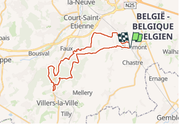
Tour Wandern von 30 km verfügbar auf Wallonien, Wallonisch-Brabant, Chastre. Diese Tour wird von Charles Lemaire vorgeschlagen.
Beschreibung
une promenade pour les gourmands, bien qu'elle puisse être abrégée en de nombreux endroits ou en faire deux boucles autour de Sart Messire Guillaume.
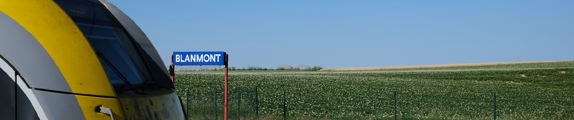
Il est aussi possible de la démarrer de la gare de Mont Saint Guibert avec très peu de modifications par rapport aux informations fournies ici.
Information intéressante pour les marcheurs en été: il y a un point d'eau (normalement pour les chiens) dans le jardin du Chalet de la Forêt (à gauche sur le mur longeant la route). Merci à eux.
Ort
Kommentare
Touren in der Umgebung
![Tour Wandern Ottignies-Louvain-la-Neuve - RL-GG-02 - Céroux-Mousty - Villers-la-Ville - 2025-02-08 - Photo](https://media.geolcdn.com/t/375/260/2eead39d-9522-4a6a-a4f3-f791e0a7304a.jpg&format=jpg&maxdim=2)
![Wandern Wandern](https://static1.geolcdn.com/sitytour/trail-icons/101.png)
Wandern
![](/images/other/stat-length.png)
![](https://static1.geolcdn.com/siteimages/upload/files/16400158638029165_repeat_loop_refresh_sync_direction_icon.png)
![Tour Wandern Mont-Saint-Guibert - Balade à Mont-Saint-Guibert - Photo](https://media.geolcdn.com/t/375/260/ext.jpg?maxdim=2&url=https%3A%2F%2Fservices.sitytrail.com%2FGeolivesWS%2FDownloadMedia.ashx%3FTrailID%3D942864%26Media%3D4a857fe0-cf43-4eb8-b563-62b2b90d4fc2.jpg)
![Wandern Wandern](https://static1.geolcdn.com/sitytour/trail-icons/101.png)
Wandern
![](/images/other/stat-length.png)
![](https://static1.geolcdn.com/siteimages/upload/files/16400158638029165_repeat_loop_refresh_sync_direction_icon.png)
![Tour Wandern Court-Saint-Étienne - RB-BW-08 - À la rencontre de trois vallées - Photo](https://media.geolcdn.com/t/375/260/ext.jpg?maxdim=2&url=https%3A%2F%2Fservices.sitytrail.com%2FGeolivesWS%2FDownloadMedia.ashx%3FTrailID%3D220267%26Media%3D6c86831f-6220-45af-ac63-82e6ea37f2ed.jpg)
![Wandern Wandern](https://static1.geolcdn.com/sitytour/trail-icons/101.png)
Wandern
![](/images/other/stat-length.png)
![](https://static1.geolcdn.com/siteimages/upload/files/16400158638029165_repeat_loop_refresh_sync_direction_icon.png)
![Wandern Wandern](https://static1.geolcdn.com/sitytour/trail-icons/101.png)
Wandern
![](/images/other/stat-length.png)
![](https://static1.geolcdn.com/siteimages/upload/files/16400158638029165_repeat_loop_refresh_sync_direction_icon.png)
![Tour Wandern Chaumont-Gistoux - #231016 - Corroy-Le-Grand et le Val d'Ocquière*** (inversé court) - Photo](https://media.geolcdn.com/t/375/260/b650de28-d96e-49f2-85c2-d640aecfc352.jpg&format=jpg&maxdim=2)
![Wandern Wandern](https://static1.geolcdn.com/sitytour/trail-icons/101.png)
Wandern
![](/images/other/stat-length.png)
![](https://static1.geolcdn.com/siteimages/upload/files/16400158638029165_repeat_loop_refresh_sync_direction_icon.png)
![Wandern Wandern](https://static1.geolcdn.com/sitytour/trail-icons/101.png)
Wandern
![](/images/other/stat-length.png)
![](https://static1.geolcdn.com/siteimages/upload/files/16400158638029165_repeat_loop_refresh_sync_direction_icon.png)
![Wandern Wandern](https://static1.geolcdn.com/sitytour/trail-icons/101.png)
Wandern
![](/images/other/stat-length.png)
![](https://static1.geolcdn.com/siteimages/upload/files/16400158638029165_repeat_loop_refresh_sync_direction_icon.png)
![Zu Fuß Zu Fuß](https://static1.geolcdn.com/sitytour/trail-icons/100.png)
Zu Fuß
![](/images/other/stat-length.png)
![](https://static1.geolcdn.com/siteimages/upload/files/16400158638029165_repeat_loop_refresh_sync_direction_icon.png)
![Tour Wandern Chastre - Promenade de Villeroux - Photo](https://media.geolcdn.com/t/375/260/ext.jpg?maxdim=2&url=https%3A%2F%2Fservices.sitytrail.com%2FGeolivesWS%2FDownloadMedia.ashx%3FTrailID%3D233658%26Media%3D6ce217ee-b2e1-442a-b4a3-34a4ee262c13.JPG)
![Wandern Wandern](https://static1.geolcdn.com/sitytour/trail-icons/101.png)
Wandern
![](/images/other/stat-length.png)
![](https://static1.geolcdn.com/siteimages/upload/files/16400158638029165_repeat_loop_refresh_sync_direction_icon.png)