![](/images/other/stat-length.png)
![Tour Peyrus - 2023-06-30_14h11m49_Cirkwi-GR_93 - Photo](https://media.geolcdn.com/t/1900/400/ext.pjpeg?maxdim=2&url=https%3A%2F%2Fsecurestorage.geolives.com%2Fsitytour%2Ftrail-bg%2Fdefault.jpg)
2023-06-30_14h11m49_Cirkwi-GR_93
Philippe DENJEAN
Benutzer
![Länge](/images/other/stat-length.png)
Länge
107 km
![Boucle](https://static1.geolcdn.com/siteimages/upload/files/16400158638029165_repeat_loop_refresh_sync_direction_icon.png)
Boucle
Nein
Erstellungsdatum :
2023-06-30 12:11:49.685
Letzte Änderung :
2023-06-30 12:11:55.158
![Scannen Sie diesen QR-Code, um die Tour in der SityTrail-Anwendung zu öffnen](https://capi.geolives.com/qq0zvz2zws4bq2lad0pu/sitytour/trails/3717631/qr.png?size=200)
Kostenlosegpshiking-Anwendung
Über SityTrail
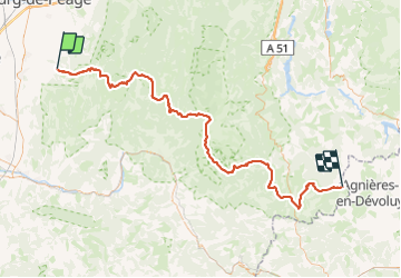
Tour von 107 km verfügbar auf Auvergne-Rhone-Alpen, Drôme, Peyrus. Diese Tour wird von Philippe DENJEAN vorgeschlagen.
Beschreibung
Le GR93 prend naissance dans la vallée du Rhône, franchit les crêtes et s'achemine vers le cœur du Vercors qu'il quitte par le cirque d'Archiane. Puis, par les reliefs des contreforts sud, il arrive à Lus-la-Croix-Haute au pied du Dévoluy.
Ort
Land:
France
Region :
Auvergne-Rhone-Alpen
Abteilung/Provinz :
Drôme
Kommune :
Peyrus
Standort:
Unknown
Gehen Sie:(Dec)
Gehen Sie:(UTM)
666472 ; 4975406 (31T) N.
Kommentare
Touren in der Umgebung
![Tour Wandern Châteaudouble - Le pont des sarazins par la fontaine des corbeaux - Photo](https://media.geolcdn.com/t/375/260/1f3934ff-cd5e-4a15-93b4-c6f716008382.jpg&format=jpg&maxdim=2)
![Wandern Wandern](https://static1.geolcdn.com/sitytour/trail-icons/101.png)
Le pont des sarazins par la fontaine des corbeaux
Wandern
Medium
(1)
Châteaudouble,
Auvergne-Rhone-Alpen,
Drôme,
France
![](/images/other/stat-length.png)
6,4 km | 11,2 km-effort
2h 57min
![](https://static1.geolcdn.com/siteimages/upload/files/16400158638029165_repeat_loop_refresh_sync_direction_icon.png)
Nein
![Tour Wandern Saint-Vincent-la-Commanderie - Pierre Chauve 1308m, les Roches de Treillaras, depuis les Condamines - Photo](https://media.geolcdn.com/t/375/260/ext.jpg?maxdim=2&url=https%3A%2F%2Fservices.sitytrail.com%2FGeolivesWS%2FDownloadMedia.ashx%3FTrailID%3D318111%26Media%3D17572_1.jpg)
![Wandern Wandern](https://static1.geolcdn.com/sitytour/trail-icons/101.png)
Pierre Chauve 1308m, les Roches de Treillaras, depuis les Condamines
Wandern
Medium
(2)
Saint-Vincent-la-Commanderie,
Auvergne-Rhone-Alpen,
Drôme,
France
![](/images/other/stat-length.png)
12,7 km | 25 km-effort
6h 30min
![](https://static1.geolcdn.com/siteimages/upload/files/16400158638029165_repeat_loop_refresh_sync_direction_icon.png)
Ja
![Tour Wandern Barcelonne - Barcelonne-Combivin-Chapelle St Marguerite - Photo](https://media.geolcdn.com/t/375/260/ext.jpg?maxdim=2&url=https%3A%2F%2Fservices.sitytrail.com%2FGeolivesWS%2FDownloadMedia.ashx%3FTrailID%3D272339%26Media%3D20140430171101.jpg)
![Wandern Wandern](https://static1.geolcdn.com/sitytour/trail-icons/101.png)
Barcelonne-Combivin-Chapelle St Marguerite
Wandern
Einfach
(1)
Barcelonne,
Auvergne-Rhone-Alpen,
Drôme,
France
![](/images/other/stat-length.png)
8,7 km | 13,5 km-effort
2h 20min
![](https://static1.geolcdn.com/siteimages/upload/files/16400158638029165_repeat_loop_refresh_sync_direction_icon.png)
Ja
![Tour Wandern Saint-Vincent-la-Commanderie - 26 st Vincent commanderie zel - Photo](https://media.geolcdn.com/t/375/260/64d0078a-2be9-41db-957b-395e9e3d9a48.jpg&format=jpg&maxdim=2)
![Wandern Wandern](https://static1.geolcdn.com/sitytour/trail-icons/101.png)
26 st Vincent commanderie zel
Wandern
Einfach
Saint-Vincent-la-Commanderie,
Auvergne-Rhone-Alpen,
Drôme,
France
![](/images/other/stat-length.png)
14,2 km | 22 km-effort
6h 5min
![](https://static1.geolcdn.com/siteimages/upload/files/16400158638029165_repeat_loop_refresh_sync_direction_icon.png)
Ja
![Tour Wandern Léoncel - les roches de treillaras - Photo](https://media.geolcdn.com/t/375/260/ext.jpg?maxdim=2&url=https%3A%2F%2Fstatic1.geolcdn.com%2Fsiteimages%2Fupload%2Ffiles%2F1553511878bg_sport_marche.png)
![Wandern Wandern](https://static1.geolcdn.com/sitytour/trail-icons/101.png)
les roches de treillaras
Wandern
Einfach
(3)
Léoncel,
Auvergne-Rhone-Alpen,
Drôme,
France
![](/images/other/stat-length.png)
11 km | 16 km-effort
2h 14min
![](https://static1.geolcdn.com/siteimages/upload/files/16400158638029165_repeat_loop_refresh_sync_direction_icon.png)
Nein
![Tour Wandern Léoncel - Rando Pas du touet -rocher de la drayette - Photo](https://media.geolcdn.com/t/375/260/ext.jpg?maxdim=2&url=https%3A%2F%2Fstatic1.geolcdn.com%2Fsiteimages%2Fupload%2Ffiles%2F1553511878bg_sport_marche.png)
![Wandern Wandern](https://static1.geolcdn.com/sitytour/trail-icons/101.png)
Rando Pas du touet -rocher de la drayette
Wandern
Einfach
(3)
Léoncel,
Auvergne-Rhone-Alpen,
Drôme,
France
![](/images/other/stat-length.png)
6,3 km | 8,8 km-effort
2h 11min
![](https://static1.geolcdn.com/siteimages/upload/files/16400158638029165_repeat_loop_refresh_sync_direction_icon.png)
Ja
![Tour Wandern Barbières - 26 pierre chauve barbieres zel - Photo](https://media.geolcdn.com/t/375/260/92caf138-cce3-4645-835e-f3491e5ff577.jpg&format=jpg&maxdim=2)
![Wandern Wandern](https://static1.geolcdn.com/sitytour/trail-icons/101.png)
26 pierre chauve barbieres zel
Wandern
Medium
Barbières,
Auvergne-Rhone-Alpen,
Drôme,
France
![](/images/other/stat-length.png)
13,8 km | 26 km-effort
7h 9min
![](https://static1.geolcdn.com/siteimages/upload/files/16400158638029165_repeat_loop_refresh_sync_direction_icon.png)
Nein
![Tour Wandern Barbières - Traversée Barbières Beauregard-Baret - Photo](https://media.geolcdn.com/t/375/260/2a3121e4-a036-4b19-8247-21a832e98ad8.jpg&format=jpg&maxdim=2)
![Wandern Wandern](https://static1.geolcdn.com/sitytour/trail-icons/101.png)
Traversée Barbières Beauregard-Baret
Wandern
Sehr schwierig
Barbières,
Auvergne-Rhone-Alpen,
Drôme,
France
![](/images/other/stat-length.png)
17 km | 28 km-effort
7h 9min
![](https://static1.geolcdn.com/siteimages/upload/files/16400158638029165_repeat_loop_refresh_sync_direction_icon.png)
Nein
![Tour Wandern Peyrus - pont des sarrasins, faucon, piaroux - Photo](https://media.geolcdn.com/t/375/260/2681339b-63d6-4100-8047-95b258aa19f5.jpg&format=jpg&maxdim=2)
![Wandern Wandern](https://static1.geolcdn.com/sitytour/trail-icons/101.png)
pont des sarrasins, faucon, piaroux
Wandern
Sehr schwierig
Peyrus,
Auvergne-Rhone-Alpen,
Drôme,
France
![](/images/other/stat-length.png)
8,3 km | 14,3 km-effort
3h 2min
![](https://static1.geolcdn.com/siteimages/upload/files/16400158638029165_repeat_loop_refresh_sync_direction_icon.png)
Ja