![](/images/other/stat-length.png)
![Tour Schneeschuhwandern Font-Romeu-Odeillo-Via - fontromeu - Photo](https://media.geolcdn.com/t/1900/400/ext.pjpeg?maxdim=2&url=https%3A%2F%2Fstatic1.geolcdn.com%2Fsiteimages%2Fupload%2Ffiles%2F1524743153raquette.jpg)
fontromeu
MarieFrancoise
Benutzer
![Länge](/images/other/stat-length.png)
Länge
11,1 km
![Maximale Höhe](https://static1.geolcdn.com/siteimages/upload/files/1508320355ic_sort_altitude_max_24dp.png)
Maximale Höhe
2214 m
![Positive Höhendifferenz](https://static1.geolcdn.com/siteimages/upload/files/1508320355ic_sort_den_pos_24dp.png)
Positive Höhendifferenz
318 m
![Km-Effort](/images/other/stat-length.png)
Km-Effort
15,4 km
![Min. Höhe](https://static1.geolcdn.com/siteimages/upload/files/1508320355ic_sort_altitude_min_24dp.png)
Min. Höhe
1935 m
![Negative Höhendifferenz](https://static1.geolcdn.com/siteimages/upload/files/1508320355ic_sort_den_neg_24dp.png)
Negative Höhendifferenz
323 m
![Boucle](https://static1.geolcdn.com/siteimages/upload/files/16400158638029165_repeat_loop_refresh_sync_direction_icon.png)
Boucle
Ja
Erstellungsdatum :
2019-05-27 16:40:46.149
Letzte Änderung :
2019-05-27 16:40:46.251
![Schneeschuhwandern](https://static1.geolcdn.com/sitytour/trail-icons/504.png)
4h36
Schwierigkeit : Einfach
![Scannen Sie diesen QR-Code, um die Tour in der SityTrail-Anwendung zu öffnen](https://capi.geolives.com/qq0zvz2zws4bq2lad0pu/sitytour/trails/370772/qr.png?size=200)
Kostenlosegpshiking-Anwendung
Über SityTrail
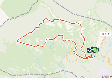
Tour Schneeschuhwandern von 11,1 km verfügbar auf Okzitanien, Ostpyrenäen, Font-Romeu-Odeillo-Via. Diese Tour wird von MarieFrancoise vorgeschlagen.
Beschreibung
Une jolie boucle sans difficultés au départ du parking de Morella dels Clos.en passant par le Pic Dels Moros puis par le refuge de la Calma
Ort
Land:
France
Region :
Okzitanien
Abteilung/Provinz :
Ostpyrenäen
Kommune :
Font-Romeu-Odeillo-Via
Standort:
Unknown
Gehen Sie:(Dec)
Gehen Sie:(UTM)
420698 ; 4708024 (31T) N.
Kommentare
Touren in der Umgebung
![Tour Wandern Font-Romeu-Odeillo-Via - Coll del Pam lac des Bouillouses - Photo](https://media.geolcdn.com/t/375/260/ext.jpg?maxdim=2&url=https%3A%2F%2Fservices.sitytrail.com%2FGeolivesWS%2FDownloadMedia.ashx%3FTrailID%3D802013%26Media%3Dfix__20170803141713.jpg)
![Wandern Wandern](https://static1.geolcdn.com/sitytour/trail-icons/101.png)
Coll del Pam lac des Bouillouses
Wandern
Medium
(2)
Font-Romeu-Odeillo-Via,
Okzitanien,
Ostpyrenäen,
France
![](/images/other/stat-length.png)
13,3 km | 19,3 km-effort
4h 10min
![](https://static1.geolcdn.com/siteimages/upload/files/16400158638029165_repeat_loop_refresh_sync_direction_icon.png)
Ja
![Tour Schneeschuhwandern Font-Romeu-Odeillo-Via - pic dels moros - Photo](https://media.geolcdn.com/t/375/260/ext.jpg?maxdim=2&url=https%3A%2F%2Fservices.sitytrail.com%2FGeolivesWS%2FDownloadMedia.ashx%3FTrailID%3D509986%26Media%3Dfix__20140323122816.jpg)
![Schneeschuhwandern Schneeschuhwandern](https://static1.geolcdn.com/sitytour/trail-icons/504.png)
pic dels moros
Schneeschuhwandern
Medium
(1)
Font-Romeu-Odeillo-Via,
Okzitanien,
Ostpyrenäen,
France
![](/images/other/stat-length.png)
12,6 km | 19,4 km-effort
4h 46min
![](https://static1.geolcdn.com/siteimages/upload/files/16400158638029165_repeat_loop_refresh_sync_direction_icon.png)
Ja
![Tour Schneeschuhwandern Les Angles - Lac d Aude -Refuge Bernardi les Angles - Photo](https://media.geolcdn.com/t/375/260/ext.jpg?maxdim=2&url=https%3A%2F%2Fservices.sitytrail.com%2FGeolivesWS%2FDownloadMedia.ashx%3FTrailID%3D400729%26Media%3Dfix__20150327134406.jpg)
![Schneeschuhwandern Schneeschuhwandern](https://static1.geolcdn.com/sitytour/trail-icons/504.png)
Lac d Aude -Refuge Bernardi les Angles
Schneeschuhwandern
Medium
(1)
Les Angles,
Okzitanien,
Ostpyrenäen,
France
![](/images/other/stat-length.png)
13,9 km | 19,1 km-effort
5h 44min
![](https://static1.geolcdn.com/siteimages/upload/files/16400158638029165_repeat_loop_refresh_sync_direction_icon.png)
Ja
![Tour Wandern Les Angles - le tour des lacs de carli - Photo](https://media.geolcdn.com/t/375/260/ext.jpg?maxdim=2&url=https%3A%2F%2Fservices.sitytrail.com%2FGeolivesWS%2FDownloadMedia.ashx%3FTrailID%3D205430%26Media%3Dfix__20130716110753.jpg)
![Wandern Wandern](https://static1.geolcdn.com/sitytour/trail-icons/101.png)
le tour des lacs de carli
Wandern
Medium
(2)
Les Angles,
Okzitanien,
Ostpyrenäen,
France
![](/images/other/stat-length.png)
11,4 km | 16,6 km-effort
3h 51min
![](https://static1.geolcdn.com/siteimages/upload/files/16400158638029165_repeat_loop_refresh_sync_direction_icon.png)
Nein
![Tour Wandern Les Angles - Rando des 12 lacs - Photo](https://media.geolcdn.com/t/375/260/ext.jpg?maxdim=2&url=https%3A%2F%2Fservices.sitytrail.com%2FGeolivesWS%2FDownloadMedia.ashx%3FTrailID%3D136989%26Media%3D20120701094842.jpg)
![Wandern Wandern](https://static1.geolcdn.com/sitytour/trail-icons/101.png)
Rando des 12 lacs
Wandern
Einfach
(1)
Les Angles,
Okzitanien,
Ostpyrenäen,
France
![](/images/other/stat-length.png)
14,1 km | 20 km-effort
6h 30min
![](https://static1.geolcdn.com/siteimages/upload/files/16400158638029165_repeat_loop_refresh_sync_direction_icon.png)
Ja
![Tour Wandern Font-Romeu-Odeillo-Via - Font Romeu Egat - Photo](https://media.geolcdn.com/t/375/260/ext.jpg?maxdim=2&url=https%3A%2F%2Fservices.sitytrail.com%2FGeolivesWS%2FDownloadMedia.ashx%3FTrailID%3D555215%26Media%3D20160418074519.jpg)
![Wandern Wandern](https://static1.geolcdn.com/sitytour/trail-icons/101.png)
Font Romeu Egat
Wandern
Medium
(2)
Font-Romeu-Odeillo-Via,
Okzitanien,
Ostpyrenäen,
France
![](/images/other/stat-length.png)
2,5 km | 3,4 km-effort
44min
![](https://static1.geolcdn.com/siteimages/upload/files/16400158638029165_repeat_loop_refresh_sync_direction_icon.png)
Ja
![Tour Schneeschuhwandern Font-Romeu-Odeillo-Via - Pic dels Moros avec Pierre - Photo](https://media.geolcdn.com/t/375/260/ext.jpg?maxdim=2&url=https%3A%2F%2Fservices.sitytrail.com%2FGeolivesWS%2FDownloadMedia.ashx%3FTrailID%3D542171%26Media%3Dfix__20160322124727.jpg)
![Schneeschuhwandern Schneeschuhwandern](https://static1.geolcdn.com/sitytour/trail-icons/504.png)
Pic dels Moros avec Pierre
Schneeschuhwandern
Medium
(1)
Font-Romeu-Odeillo-Via,
Okzitanien,
Ostpyrenäen,
France
![](/images/other/stat-length.png)
10,5 km | 15,9 km-effort
4h 4min
![](https://static1.geolcdn.com/siteimages/upload/files/16400158638029165_repeat_loop_refresh_sync_direction_icon.png)
Ja
![Tour Wandern Égat - Egat Puig Moro - Photo](https://media.geolcdn.com/t/375/260/ext.jpg?maxdim=2&url=https%3A%2F%2Fservices.sitytrail.com%2FGeolivesWS%2FDownloadMedia.ashx%3FTrailID%3D460362%26Media%3Dfix__20150817141649.jpg)
![Wandern Wandern](https://static1.geolcdn.com/sitytour/trail-icons/101.png)
Egat Puig Moro
Wandern
Medium
(1)
Égat,
Okzitanien,
Ostpyrenäen,
France
![](/images/other/stat-length.png)
13,4 km | 19,3 km-effort
4h 51min
![](https://static1.geolcdn.com/siteimages/upload/files/16400158638029165_repeat_loop_refresh_sync_direction_icon.png)
Ja
![Tour Wandern Égat - La croix d'Egat - Photo](https://media.geolcdn.com/t/375/260/ext.jpg?maxdim=2&url=https%3A%2F%2Fservices.sitytrail.com%2FGeolivesWS%2FDownloadMedia.ashx%3FTrailID%3D143230%26Media%3D20120803102022.jpeg)
![Wandern Wandern](https://static1.geolcdn.com/sitytour/trail-icons/101.png)
La croix d'Egat
Wandern
Einfach
(1)
Égat,
Okzitanien,
Ostpyrenäen,
France
![](/images/other/stat-length.png)
7,1 km | 10,4 km-effort
2h 2min
![](https://static1.geolcdn.com/siteimages/upload/files/16400158638029165_repeat_loop_refresh_sync_direction_icon.png)
Ja