![](/images/other/stat-length.png)
Tour du Lac du Bimont
ericberlin
Benutzer
![Länge](/images/other/stat-length.png)
![Maximale Höhe](https://static1.geolcdn.com/siteimages/upload/files/1508320355ic_sort_altitude_max_24dp.png)
![Positive Höhendifferenz](https://static1.geolcdn.com/siteimages/upload/files/1508320355ic_sort_den_pos_24dp.png)
![Km-Effort](/images/other/stat-length.png)
![Min. Höhe](https://static1.geolcdn.com/siteimages/upload/files/1508320355ic_sort_altitude_min_24dp.png)
![Negative Höhendifferenz](https://static1.geolcdn.com/siteimages/upload/files/1508320355ic_sort_den_neg_24dp.png)
![Boucle](https://static1.geolcdn.com/siteimages/upload/files/16400158638029165_repeat_loop_refresh_sync_direction_icon.png)
![Wandern](https://static1.geolcdn.com/sitytour/trail-icons/101.png)
3h37
Schwierigkeit : Schwierig
![Scannen Sie diesen QR-Code, um die Tour in der SityTrail-Anwendung zu öffnen](https://capi.geolives.com/qq0zvz2zws4bq2lad0pu/sitytour/trails/3704321/qr.png?size=200)
Kostenlosegpshiking-Anwendung
Über SityTrail
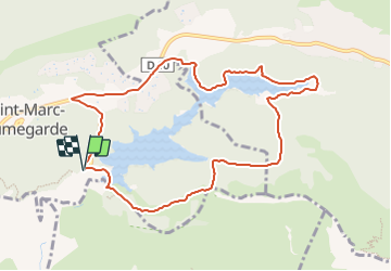
Tour Wandern von 10,3 km verfügbar auf Provence-Alpes-Côte d'Azur, Bouches-du-Rhône, Saint-Marc-Jaumegarde. Diese Tour wird von ericberlin vorgeschlagen.
Beschreibung
L’été, consulter la carte des autorisations d’accès au massifs forestiers dans le 13 en fonction du risque d’incendies :
0811 20 13 13
http://bpatp.paca-ate.fr/
credits: https://www.visorando.com/randonnee-tour-du-lac-du-bimont/
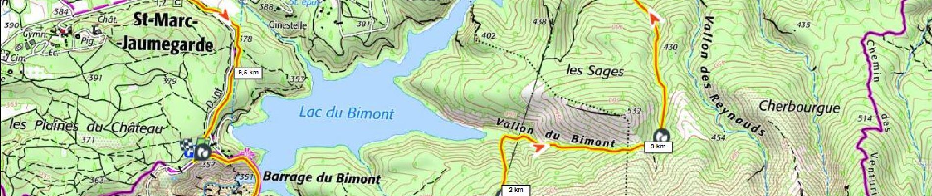
Partir à droite et emprunter le barrage puis le Sentier Imoucha (panneau balisage Bleu) à gauche. Le suivre en ignorant tous les départs de sentiers à gauche et à droite jusqu'à rencontrer un pylône électrique.
(1) Au pied du pylône, quitter le Sentier Imoucha pour s'engager vers le Nord sur un sentier non balisé (ce dernier n'apparaît pas sur la carte IGN). Suivre au départ la ligne électrique, à travers la végétation. Le sentier descend assez raide jusqu'au fond du Vallon du Bimont puis remonte ensuite tranquillement vers l'Est.
(2) Au point culminant du sentier, bifurquer vers le Nord par une ancienne piste qui descend vers le lac.
(3) Arrivé au lac, partir à droite et contourner celui-ci par l'Est pour revenir sur l'autre rive.
(4) Arrivé au premier grand bras d'eau, le contourner et s'engager en face sur un sentier assez visible mais peu emprunté, quelques broussailles et arbustes viendront probablement se frotter gentiment à vous (ne figure pas entièrement sur la carte IGN). Le sentier longe la côte, parfois en hauteur, et permet de jolis point de vue sur le lac. Ensuite, il finit par longer un grand bras d'eau en remontant vers le Nord.
(5) Contourner l'extrémité du bras d'eau pour rattraper un petit sentier sur quelques mètres puis arriver à une large piste.
(6) Remonter celle-ci puis à la route (D 10), la suivre à gauche, sur l'accotement, environ 1 km avant de retrouver la petite route d'accès au parking du barrage.
(7) Un sentier balisé Jaune longe la route (D10f) et ramène au parking (D/A).
Ort
Kommentare
Touren in der Umgebung
![Tour Wandern Saint-Antonin-sur-Bayon - Ste Victoire - Le Garagaï - Photo](https://media.geolcdn.com/t/375/260/2ae6dfca-d10e-4ad0-a555-d7a2df31e780.jpg&format=jpg&maxdim=2)
![Wandern Wandern](https://static1.geolcdn.com/sitytour/trail-icons/101.png)
Wandern
![](/images/other/stat-length.png)
![](https://static1.geolcdn.com/siteimages/upload/files/16400158638029165_repeat_loop_refresh_sync_direction_icon.png)
![Tour Wandern Aix-en-Provence - Circuit des lacs Zola et Bimont - Aix-en-Provence - Photo](https://media.geolcdn.com/t/375/260/ext.jpg?maxdim=2&url=https%3A%2F%2Fservices.sitytrail.com%2FGeolivesWS%2FDownloadMedia.ashx%3FTrailID%3D173043%26Media%3D14560_6.jpg)
![Wandern Wandern](https://static1.geolcdn.com/sitytour/trail-icons/101.png)
Wandern
![](/images/other/stat-length.png)
![](https://static1.geolcdn.com/siteimages/upload/files/16400158638029165_repeat_loop_refresh_sync_direction_icon.png)
![Tour Wandern Saint-Marc-Jaumegarde - Barrages Zola-Bimont - Photo](https://media.geolcdn.com/t/375/260/4dc70101-718b-4211-92e1-c206f426269b.jpg&format=jpg&maxdim=2)
![Wandern Wandern](https://static1.geolcdn.com/sitytour/trail-icons/101.png)
Wandern
![](/images/other/stat-length.png)
![](https://static1.geolcdn.com/siteimages/upload/files/16400158638029165_repeat_loop_refresh_sync_direction_icon.png)
![Tour Wandern Vauvenargues - Le Signal, Montagne Sainte-Victoire - Photo](https://media.geolcdn.com/t/375/260/ext.jpg?maxdim=2&url=https%3A%2F%2Fservices.sitytrail.com%2FGeolivesWS%2FDownloadMedia.ashx%3FTrailID%3D106346%26Media%3D10812_1.jpg)
![Wandern Wandern](https://static1.geolcdn.com/sitytour/trail-icons/101.png)
Wandern
![](/images/other/stat-length.png)
![](https://static1.geolcdn.com/siteimages/upload/files/16400158638029165_repeat_loop_refresh_sync_direction_icon.png)
![Tour Wandern Saint-Marc-Jaumegarde - La Croix de Provence depuis le barrage de Bimont - Photo](https://media.geolcdn.com/t/375/260/ext.jpg?maxdim=2&url=https%3A%2F%2Fservices.sitytrail.com%2FGeolivesWS%2FDownloadMedia.ashx%3FTrailID%3D103825%26Media%3D6599_1.jpg)
![Wandern Wandern](https://static1.geolcdn.com/sitytour/trail-icons/101.png)
Wandern
![](/images/other/stat-length.png)
![](https://static1.geolcdn.com/siteimages/upload/files/16400158638029165_repeat_loop_refresh_sync_direction_icon.png)
![Tour Wandern Saint-Marc-Jaumegarde - Randonnée des crêtes au départ du barrage de Bimont - Photo](https://media.geolcdn.com/t/375/260/f5fd4b67-08c6-4cdc-bfa9-7a770b929a06.jpg&format=jpg&maxdim=2)
![Wandern Wandern](https://static1.geolcdn.com/sitytour/trail-icons/101.png)
Wandern
![](/images/other/stat-length.png)
![](https://static1.geolcdn.com/siteimages/upload/files/16400158638029165_repeat_loop_refresh_sync_direction_icon.png)
![Tour Wandern Aix-en-Provence - Randonnée des barrages Zola et Bimont - Photo](https://media.geolcdn.com/t/375/260/6cce4a57-5683-4820-95a9-df589c3aadcb.jpg&format=jpg&maxdim=2)
![Wandern Wandern](https://static1.geolcdn.com/sitytour/trail-icons/101.png)
Wandern
![](/images/other/stat-length.png)
![](https://static1.geolcdn.com/siteimages/upload/files/16400158638029165_repeat_loop_refresh_sync_direction_icon.png)
![Tour Wandern Le Tholonet - Le Tholonet -La Croix de Provence Par les Lacs Zola et Bimont - Photo](https://media.geolcdn.com/t/375/260/c97ea994-b71a-4c79-84a6-ec8711624c80.jpg&format=jpg&maxdim=2)
![Wandern Wandern](https://static1.geolcdn.com/sitytour/trail-icons/101.png)
Wandern
![](/images/other/stat-length.png)
![](https://static1.geolcdn.com/siteimages/upload/files/16400158638029165_repeat_loop_refresh_sync_direction_icon.png)
![Tour Wandern Saint-Antonin-sur-Bayon - 2023-02-10 Sainte Victoire Bau des Vespres - Photo](https://media.geolcdn.com/t/375/260/36cf2b9f-8e2f-45fe-90b0-1fa100759227.jpg&format=jpg&maxdim=2)
![Wandern Wandern](https://static1.geolcdn.com/sitytour/trail-icons/101.png)
Wandern
![](/images/other/stat-length.png)
![](https://static1.geolcdn.com/siteimages/upload/files/16400158638029165_repeat_loop_refresh_sync_direction_icon.png)