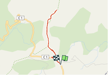
![](/images/other/stat-length.png)
![Tour Wandern Jausiers - Du col de Restefond, Mourre Haut - Photo](https://media.geolcdn.com/t/1900/400/b5130266-8ed9-4d64-b271-5afc7d36d1fe.jpg&format=pjpeg&maxdim=2)
Du col de Restefond, Mourre Haut
GrouGary
Benutzer
![Länge](/images/other/stat-length.png)
![Maximale Höhe](https://static1.geolcdn.com/siteimages/upload/files/1508320355ic_sort_altitude_max_24dp.png)
![Positive Höhendifferenz](https://static1.geolcdn.com/siteimages/upload/files/1508320355ic_sort_den_pos_24dp.png)
![Km-Effort](/images/other/stat-length.png)
![Min. Höhe](https://static1.geolcdn.com/siteimages/upload/files/1508320355ic_sort_altitude_min_24dp.png)
![Negative Höhendifferenz](https://static1.geolcdn.com/siteimages/upload/files/1508320355ic_sort_den_neg_24dp.png)
![Boucle](https://static1.geolcdn.com/siteimages/upload/files/16400158638029165_repeat_loop_refresh_sync_direction_icon.png)
![Wandern](https://static1.geolcdn.com/sitytour/trail-icons/101.png)
1h32
Schwierigkeit : Einfach
![Scannen Sie diesen QR-Code, um die Tour in der SityTrail-Anwendung zu öffnen](https://capi.geolives.com/qq0zvz2zws4bq2lad0pu/sitytour/trails/3692401/qr.png?size=200)
Kostenlosegpshiking-Anwendung
Über SityTrail
Tour Wandern von 3,6 km verfügbar auf Provence-Alpes-Côte d'Azur, Alpes-de-Haute-Provence, Jausiers. Diese Tour wird von GrouGary vorgeschlagen.
Beschreibung
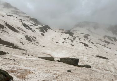
Petite randonnée d'une matinée/pluie annoncée à 14h (sans erreur) ;
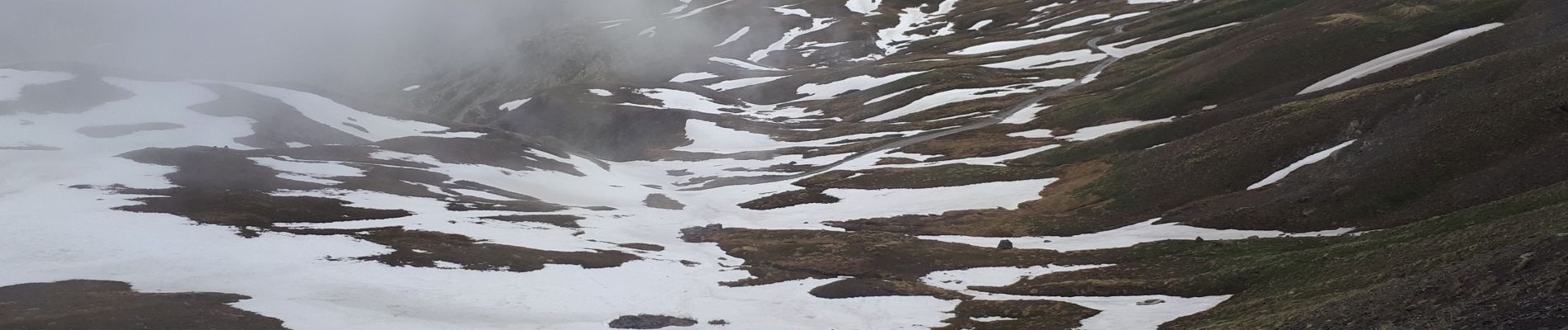
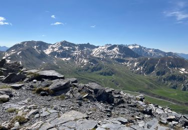
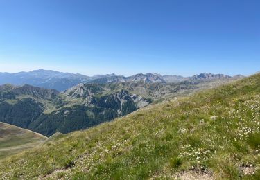
Ligne de crête permettant d'avoir une vue Nord-Est sur le Vallon des Granges communes, et plus loin sur le rocher des Trois Evêques, entourés de son écharpe de brume.
Au Nord, la Tête de l'Empeloutier (2728m)
Vers le Sud, la cime de La Bonnette (2860m) est masquée partiellement, ...
Le brouillard se lève dévoilant des vallons verdissant partiellement comblés de neige, panorama à la manière de Matisse : Beauté !
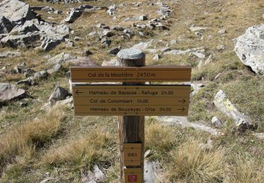
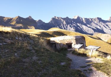
Retour sur le Camp des Fourches : montée vers le Fortin du Mont des Fourches;
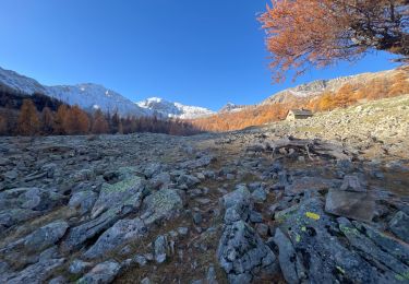
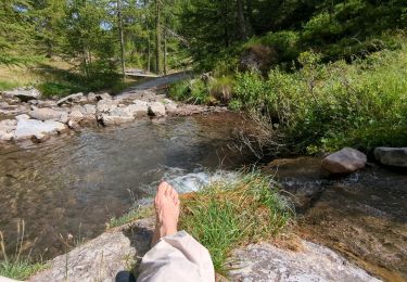
Bonnes bières au Gite de Bousiéyas avec vue sur la cime de la Blanche, de la Tête de vinaigre et surtout le vallon vert de La Fourchairé
Ort
Kommentare
Touren in der Umgebung
![Tour Zu Fuß Uvernet-Fours - Pointe de Colombart - Photo](https://media.geolcdn.com/t/375/260/5fc579df-5419-4dca-9bed-ffaaf89250e9.jpeg&format=jpg&maxdim=2)
![Zu Fuß Zu Fuß](https://static1.geolcdn.com/sitytour/trail-icons/100.png)
Zu Fuß
![](/images/other/stat-length.png)
![](https://static1.geolcdn.com/siteimages/upload/files/16400158638029165_repeat_loop_refresh_sync_direction_icon.png)
![Tour Zu Fuß Saint-Dalmas-le-Selvage - Crête de la Blanche - Photo](https://media.geolcdn.com/t/375/260/8fef9bcd-e2c1-4a5f-8511-8141c69ceadb.jpeg&format=jpg&maxdim=2)
![Zu Fuß Zu Fuß](https://static1.geolcdn.com/sitytour/trail-icons/100.png)
Zu Fuß
![](/images/other/stat-length.png)
![](https://static1.geolcdn.com/siteimages/upload/files/16400158638029165_repeat_loop_refresh_sync_direction_icon.png)
![Tour Wandern Saint-Dalmas-le-Selvage - crete de la blanche (sens inverse des aiguilles de la montre) - Photo](https://media.geolcdn.com/t/375/260/8277ee34-7f4f-4605-8ad8-3f70e64ea507.jpg&format=jpg&maxdim=2)
![Wandern Wandern](https://static1.geolcdn.com/sitytour/trail-icons/101.png)
Wandern
![](/images/other/stat-length.png)
![](https://static1.geolcdn.com/siteimages/upload/files/16400158638029165_repeat_loop_refresh_sync_direction_icon.png)
![Tour Wandern Saint-Dalmas-le-Selvage - Tête de la Clape - Photo](https://media.geolcdn.com/t/375/260/0e3fdea2-c0e9-46f3-8d17-68d5856dfe0e.jpg&format=jpg&maxdim=2)
![Wandern Wandern](https://static1.geolcdn.com/sitytour/trail-icons/101.png)
Wandern
![](/images/other/stat-length.png)
![](https://static1.geolcdn.com/siteimages/upload/files/16400158638029165_repeat_loop_refresh_sync_direction_icon.png)
![Tour Wandern Saint-Dalmas-le-Selvage - Tête de Pelouse - Photo](https://media.geolcdn.com/t/375/260/9a5482ac-c9e1-4fdd-b971-08abe30b04a5.jpg&format=jpg&maxdim=2)
![Wandern Wandern](https://static1.geolcdn.com/sitytour/trail-icons/101.png)
Wandern
![](/images/other/stat-length.png)
![](https://static1.geolcdn.com/siteimages/upload/files/16400158638029165_repeat_loop_refresh_sync_direction_icon.png)
![Tour Wandern Saint-Dalmas-le-Selvage - Col de la Braïssa - Photo](https://media.geolcdn.com/t/375/260/170d0a5a-0a27-455b-95e1-d5466fcdcb91.jpg&format=jpg&maxdim=2)
![Wandern Wandern](https://static1.geolcdn.com/sitytour/trail-icons/101.png)
Wandern
![](/images/other/stat-length.png)
![](https://static1.geolcdn.com/siteimages/upload/files/16400158638029165_repeat_loop_refresh_sync_direction_icon.png)
![Tour Wandern Saint-Dalmas-le-Selvage - cime de pelousette - Photo](https://media.geolcdn.com/t/375/260/cbfa7615-3cbc-490f-934a-e77c417ce5e1.jpg&format=jpg&maxdim=2)
![Wandern Wandern](https://static1.geolcdn.com/sitytour/trail-icons/101.png)
Wandern
![](/images/other/stat-length.png)
![](https://static1.geolcdn.com/siteimages/upload/files/16400158638029165_repeat_loop_refresh_sync_direction_icon.png)
![Tour Wandern Saint-Dalmas-le-Selvage - Sestrieres - col de Braïssa - Photo](https://media.geolcdn.com/t/375/260/dd0ea3c4-8af4-4c42-9f9e-1a7bed2e435d.jpg&format=jpg&maxdim=2)
![Wandern Wandern](https://static1.geolcdn.com/sitytour/trail-icons/101.png)
Wandern
![](/images/other/stat-length.png)
![](https://static1.geolcdn.com/siteimages/upload/files/16400158638029165_repeat_loop_refresh_sync_direction_icon.png)
![Tour Wandern Saint-Dalmas-le-Selvage - Le Castel de la Tour - Photo](https://media.geolcdn.com/t/375/260/252f5756-caa4-41aa-bd08-7863a98e5fe6.jpg&format=jpg&maxdim=2)
![Wandern Wandern](https://static1.geolcdn.com/sitytour/trail-icons/101.png)
Wandern
![](/images/other/stat-length.png)
![](https://static1.geolcdn.com/siteimages/upload/files/16400158638029165_repeat_loop_refresh_sync_direction_icon.png)