![](/images/other/stat-length.png)
![Tour Radtourismus Montlouis-sur-Loire - De Montlouis sur Loire à Villandry - Photo](https://media.geolcdn.com/t/1900/400/06e7a589-0b86-4225-a7bb-150a85f87cea.jpg&format=pjpeg&maxdim=2)
De Montlouis sur Loire à Villandry
nadd73
Benutzer GUIDE
![Länge](/images/other/stat-length.png)
Länge
78 km
![Maximale Höhe](https://static1.geolcdn.com/siteimages/upload/files/1508320355ic_sort_altitude_max_24dp.png)
Maximale Höhe
86 m
![Positive Höhendifferenz](https://static1.geolcdn.com/siteimages/upload/files/1508320355ic_sort_den_pos_24dp.png)
Positive Höhendifferenz
510 m
![Km-Effort](/images/other/stat-length.png)
Km-Effort
85 km
![Min. Höhe](https://static1.geolcdn.com/siteimages/upload/files/1508320355ic_sort_altitude_min_24dp.png)
Min. Höhe
38 m
![Negative Höhendifferenz](https://static1.geolcdn.com/siteimages/upload/files/1508320355ic_sort_den_neg_24dp.png)
Negative Höhendifferenz
479 m
![Boucle](https://static1.geolcdn.com/siteimages/upload/files/16400158638029165_repeat_loop_refresh_sync_direction_icon.png)
Boucle
Nein
Erstellungsdatum :
2023-05-31 07:42:06.792
Letzte Änderung :
2023-05-31 18:03:15.579
![Radtourismus](https://static1.geolcdn.com/sitytour/trail-icons/204.png)
5h18
Schwierigkeit : Medium
![Scannen Sie diesen QR-Code, um die Tour in der SityTrail-Anwendung zu öffnen](https://capi.geolives.com/qq0zvz2zws4bq2lad0pu/sitytour/trails/3682636/qr.png?size=200)
Kostenlosegpshiking-Anwendung
Über SityTrail
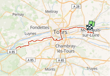
Tour Radtourismus von 78 km verfügbar auf Zentrum-Loiretal, Indre-et-Loire, Montlouis-sur-Loire. Diese Tour wird von nadd73 vorgeschlagen.
Beschreibung
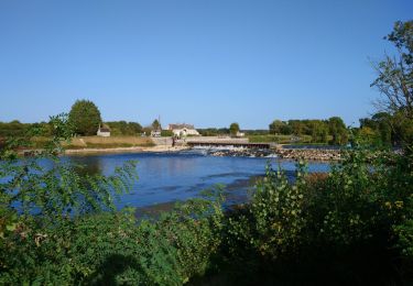
J'ai fait des détours car je me suis réapprovisionnée ou j'ai profité du croassement des grenouilles.
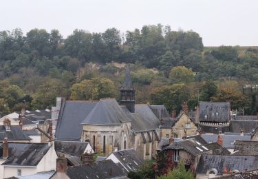
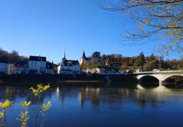
Joli avec le lac de Bergeonnerie ou le parc de la Gloriette tout près de Tours. J'ai apprécié aussi Savonnières.
Ort
Land:
France
Region :
Zentrum-Loiretal
Abteilung/Provinz :
Indre-et-Loire
Kommune :
Montlouis-sur-Loire
Standort:
Unknown
Gehen Sie:(Dec)
Gehen Sie:(UTM)
334846 ; 5251304 (31T) N.
Kommentare
Touren in der Umgebung
![Tour Wandern Vernou-sur-Brenne - Vernou-sur-Brenne la Coudraie - Zig Zag Vaubrault Noizay - 27.1km 385m 5h55 (55mn) - 2024 11 03 - Photo](https://media.geolcdn.com/t/375/260/9c945cd3-c4f0-44b2-b00c-aa0430042429.jpg&format=jpg&maxdim=2)
![Wandern Wandern](https://static1.geolcdn.com/sitytour/trail-icons/101.png)
Vernou-sur-Brenne la Coudraie - Zig Zag Vaubrault Noizay - 27.1km 385m 5h55 (...
Wandern
Einfach
Vernou-sur-Brenne,
Zentrum-Loiretal,
Indre-et-Loire,
France
![](/images/other/stat-length.png)
27 km | 32 km-effort
5h 55min
![](https://static1.geolcdn.com/siteimages/upload/files/16400158638029165_repeat_loop_refresh_sync_direction_icon.png)
Ja
![Tour Wandern Véretz - Véretz - PR Sentier de Bacchus - 14.9km 90m 3h00 - 2023 11 25 - Photo](https://media.geolcdn.com/t/375/260/ba6757e2-3664-4b27-83f8-18e13d10493f.jpg&format=jpg&maxdim=2)
![Wandern Wandern](https://static1.geolcdn.com/sitytour/trail-icons/101.png)
Véretz - PR Sentier de Bacchus - 14.9km 90m 3h00 - 2023 11 25
Wandern
Einfach
Véretz,
Zentrum-Loiretal,
Indre-et-Loire,
France
![](/images/other/stat-length.png)
14,9 km | 16,1 km-effort
3h 0min
![](https://static1.geolcdn.com/siteimages/upload/files/16400158638029165_repeat_loop_refresh_sync_direction_icon.png)
Ja
![Tour Wandern Montlouis-sur-Loire - Montlouis-sur-Loire - gare GR41 Veretz Azay-sur-Cher - 13km 85m 2h45 - 2023 10 07 - Photo](https://media.geolcdn.com/t/375/260/0a795f12-7cb8-451f-a494-3acd28ec6c5f.jpg&format=jpg&maxdim=2)
![Wandern Wandern](https://static1.geolcdn.com/sitytour/trail-icons/101.png)
Montlouis-sur-Loire - gare GR41 Veretz Azay-sur-Cher - 13km 85m 2h45 - 2023 1...
Wandern
Einfach
Montlouis-sur-Loire,
Zentrum-Loiretal,
Indre-et-Loire,
France
![](/images/other/stat-length.png)
13 km | 14,2 km-effort
2h 45min
![](https://static1.geolcdn.com/siteimages/upload/files/16400158638029165_repeat_loop_refresh_sync_direction_icon.png)
Ja
![Tour Wandern Azay-sur-Cher - Azay-sur-Cher - le Grais - 13.1km 100m 2h55 - 2023 07 12 - Photo](https://media.geolcdn.com/t/375/260/d448dc7e-b6fc-44df-a494-9561910205cc.jpg&format=jpg&maxdim=2)
![Wandern Wandern](https://static1.geolcdn.com/sitytour/trail-icons/101.png)
Azay-sur-Cher - le Grais - 13.1km 100m 2h55 - 2023 07 12
Wandern
Einfach
Azay-sur-Cher,
Zentrum-Loiretal,
Indre-et-Loire,
France
![](/images/other/stat-length.png)
13,1 km | 14,5 km-effort
2h 55min
![](https://static1.geolcdn.com/siteimages/upload/files/16400158638029165_repeat_loop_refresh_sync_direction_icon.png)
Ja
![Tour Wandern Montlouis-sur-Loire - Montlouis-sur-Loire - PR Sur les pas de Gabrielle d'Estrées - 9.5km 100m 2h20 - 2023 07 08 - Photo](https://media.geolcdn.com/t/375/260/b211a3c9-f8d2-42f6-bf4b-d2bf5553a450.jpg&format=jpg&maxdim=2)
![Wandern Wandern](https://static1.geolcdn.com/sitytour/trail-icons/101.png)
Montlouis-sur-Loire - PR Sur les pas de Gabrielle d'Estrées - 9.5km 100m 2h20...
Wandern
Einfach
Montlouis-sur-Loire,
Zentrum-Loiretal,
Indre-et-Loire,
France
![](/images/other/stat-length.png)
9,5 km | 10,9 km-effort
2h 20min
![](https://static1.geolcdn.com/siteimages/upload/files/16400158638029165_repeat_loop_refresh_sync_direction_icon.png)
Ja
![Tour Wandern Vouvray - Vouvray - PR balisé en bleu - 15.1km 125m 3h30 - 2023 06 28 - Photo](https://media.geolcdn.com/t/375/260/60d19163-b23a-4217-bba8-93e697ea97cd.jpg&format=jpg&maxdim=2)
![Wandern Wandern](https://static1.geolcdn.com/sitytour/trail-icons/101.png)
Vouvray - PR balisé en bleu - 15.1km 125m 3h30 - 2023 06 28
Wandern
Einfach
Vouvray,
Zentrum-Loiretal,
Indre-et-Loire,
France
![](/images/other/stat-length.png)
15,1 km | 16,8 km-effort
3h 30min
![](https://static1.geolcdn.com/siteimages/upload/files/16400158638029165_repeat_loop_refresh_sync_direction_icon.png)
Ja
![Tour Wandern Vernou-sur-Brenne - Vernou-sur-Brenne - Variante Sentier Vignes et Patrimoine - 10.9km 140m 2h30 (25mn) - 2023 06 28 - Photo](https://media.geolcdn.com/t/375/260/1dfb41e2-d3bf-47c9-be6e-516142895db1.jpg&format=jpg&maxdim=2)
![Wandern Wandern](https://static1.geolcdn.com/sitytour/trail-icons/101.png)
Vernou-sur-Brenne - Variante Sentier Vignes et Patrimoine - 10.9km 140m 2h30 ...
Wandern
Einfach
Vernou-sur-Brenne,
Zentrum-Loiretal,
Indre-et-Loire,
France
![](/images/other/stat-length.png)
10,9 km | 12,8 km-effort
2h 30min
![](https://static1.geolcdn.com/siteimages/upload/files/16400158638029165_repeat_loop_refresh_sync_direction_icon.png)
Ja
![Tour Wandern Montlouis-sur-Loire - Montlouis-sur-Loire - Entre Loire et vignes GR3 GR655est - 17.4km 190m 3h55 - 2022 10 16 - Photo](https://media.geolcdn.com/t/375/260/e654fc0b-8c0f-40ae-a5a9-a83b98260b2c.jpg&format=jpg&maxdim=2)
![Wandern Wandern](https://static1.geolcdn.com/sitytour/trail-icons/101.png)
Montlouis-sur-Loire - Entre Loire et vignes GR3 GR655est - 17.4km 190m 3h55 -...
Wandern
Einfach
Montlouis-sur-Loire,
Zentrum-Loiretal,
Indre-et-Loire,
France
![](/images/other/stat-length.png)
17,4 km | 19,9 km-effort
3h 55min
![](https://static1.geolcdn.com/siteimages/upload/files/16400158638029165_repeat_loop_refresh_sync_direction_icon.png)
Ja
![Tour Wandern Vernou-sur-Brenne - Vernou-sur-Brenne - Jallanges Vouvray Compostelle - 16km 180m 3h40 - 2022 07 06 - Photo](https://media.geolcdn.com/t/375/260/11853780-481a-448d-9804-5455bdcf37ee.jpg&format=jpg&maxdim=2)
![Wandern Wandern](https://static1.geolcdn.com/sitytour/trail-icons/101.png)
Vernou-sur-Brenne - Jallanges Vouvray Compostelle - 16km 180m 3h40 - 2022 07 06
Wandern
Einfach
Vernou-sur-Brenne,
Zentrum-Loiretal,
Indre-et-Loire,
France
![](/images/other/stat-length.png)
16 km | 18,4 km-effort
3h 40min
![](https://static1.geolcdn.com/siteimages/upload/files/16400158638029165_repeat_loop_refresh_sync_direction_icon.png)
Ja