![](/images/other/stat-length.png)
![Tour Mountainbike Gardanne - Canal Gardanne-Meyreuil-Fuveau - Photo](https://media.geolcdn.com/t/1900/400/ext.pjpeg?maxdim=2&url=https%3A%2F%2Fstatic1.geolcdn.com%2Fsiteimages%2Fupload%2Ffiles%2F1524743154velo.jpg)
Canal Gardanne-Meyreuil-Fuveau
j13120
Benutzer
![Länge](/images/other/stat-length.png)
Länge
24 km
![Maximale Höhe](https://static1.geolcdn.com/siteimages/upload/files/1508320355ic_sort_altitude_max_24dp.png)
Maximale Höhe
355 m
![Positive Höhendifferenz](https://static1.geolcdn.com/siteimages/upload/files/1508320355ic_sort_den_pos_24dp.png)
Positive Höhendifferenz
347 m
![Km-Effort](/images/other/stat-length.png)
Km-Effort
28 km
![Min. Höhe](https://static1.geolcdn.com/siteimages/upload/files/1508320355ic_sort_altitude_min_24dp.png)
Min. Höhe
217 m
![Negative Höhendifferenz](https://static1.geolcdn.com/siteimages/upload/files/1508320355ic_sort_den_neg_24dp.png)
Negative Höhendifferenz
347 m
![Boucle](https://static1.geolcdn.com/siteimages/upload/files/16400158638029165_repeat_loop_refresh_sync_direction_icon.png)
Boucle
Ja
Erstellungsdatum :
2014-12-10 00:00:00.0
Letzte Änderung :
2014-12-10 00:00:00.0
![Mountainbike](https://static1.geolcdn.com/sitytour/trail-icons/202.png)
1h53
Schwierigkeit : Unbekannt
![Scannen Sie diesen QR-Code, um die Tour in der SityTrail-Anwendung zu öffnen](https://capi.geolives.com/qq0zvz2zws4bq2lad0pu/sitytour/trails/367966/qr.png?size=200)
Kostenlosegpshiking-Anwendung
Über SityTrail
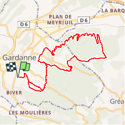
Tour Mountainbike von 24 km verfügbar auf Provence-Alpes-Côte d'Azur, Bouches-du-Rhône, Gardanne. Diese Tour wird von j13120 vorgeschlagen.
Beschreibung
Départ sur le parking du Collège le Pesquier.
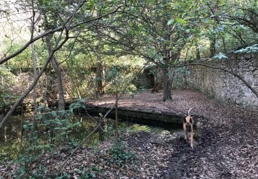
Parcours longeant le canal, beau chemin facilement praticable, sans difficulté particulière.
Ort
Land:
France
Region :
Provence-Alpes-Côte d'Azur
Abteilung/Provinz :
Bouches-du-Rhône
Kommune :
Gardanne
Standort:
Unknown
Gehen Sie:(Dec)
Gehen Sie:(UTM)
699778 ; 4813124 (31T) N.
Kommentare
Touren in der Umgebung
![Tour Wandern Simiane-Collongue - chemin de gui - Photo](https://media.geolcdn.com/t/375/260/ext.jpg?maxdim=2&url=https%3A%2F%2Fservices.sitytrail.com%2FGeolivesWS%2FDownloadMedia.ashx%3FTrailID%3D902615%26Media%3D20180210121457.jpg)
![Wandern Wandern](https://static1.geolcdn.com/sitytour/trail-icons/101.png)
chemin de gui
Wandern
Einfach
(1)
Simiane-Collongue,
Provence-Alpes-Côte d'Azur,
Bouches-du-Rhône,
France
![](/images/other/stat-length.png)
5,9 km | 8,1 km-effort
1h 45min
![](https://static1.geolcdn.com/siteimages/upload/files/16400158638029165_repeat_loop_refresh_sync_direction_icon.png)
Ja
![Tour Laufen Bouc-Bel-Air - Balade à Bouc Bel Air - Photo](https://media.geolcdn.com/t/375/260/ext.jpg?maxdim=2&url=https%3A%2F%2Fservices.sitytrail.com%2FGeolivesWS%2FDownloadMedia.ashx%3FTrailID%3D106593%26Media%3D11177_1.jpg)
![Laufen Laufen](https://static1.geolcdn.com/sitytour/trail-icons/103.png)
Balade à Bouc Bel Air
Laufen
Medium
(1)
Bouc-Bel-Air,
Provence-Alpes-Côte d'Azur,
Bouches-du-Rhône,
France
![](/images/other/stat-length.png)
6,6 km | 8,7 km-effort
34min
![](https://static1.geolcdn.com/siteimages/upload/files/16400158638029165_repeat_loop_refresh_sync_direction_icon.png)
Ja
![Tour Wandern Simiane-Collongue - SityTrail - Etoile-Petit Sanguin - Photo](https://media.geolcdn.com/t/375/260/82a74cf5-866f-40df-bc18-cb0499817c37.jpg&format=jpg&maxdim=2)
![Wandern Wandern](https://static1.geolcdn.com/sitytour/trail-icons/101.png)
SityTrail - Etoile-Petit Sanguin
Wandern
Simiane-Collongue,
Provence-Alpes-Côte d'Azur,
Bouches-du-Rhône,
France
![](/images/other/stat-length.png)
14,8 km | 21 km-effort
4h 43min
![](https://static1.geolcdn.com/siteimages/upload/files/16400158638029165_repeat_loop_refresh_sync_direction_icon.png)
Ja
![Tour Mountainbike Bouc-Bel-Air - MOUNINE - Photo](https://media.geolcdn.com/t/375/260/ext.jpg?maxdim=2&url=https%3A%2F%2Fstatic1.geolcdn.com%2Fsiteimages%2Fupload%2Ffiles%2F1524743154velo.jpg)
![Mountainbike Mountainbike](https://static1.geolcdn.com/sitytour/trail-icons/202.png)
MOUNINE
Mountainbike
Schwierig
(2)
Bouc-Bel-Air,
Provence-Alpes-Côte d'Azur,
Bouches-du-Rhône,
France
![](/images/other/stat-length.png)
20 km | 28 km-effort
3h 0min
![](https://static1.geolcdn.com/siteimages/upload/files/16400158638029165_repeat_loop_refresh_sync_direction_icon.png)
Ja
![Tour Elektrofahrrad Simiane-Collongue - LES MARRES PILON DU ROI - Photo](https://media.geolcdn.com/t/375/260/c4b78727-69dd-44a9-a9a1-4c1c067165d9.jpg&format=jpg&maxdim=2)
![Elektrofahrrad Elektrofahrrad](https://static1.geolcdn.com/sitytour/trail-icons/205.png)
LES MARRES PILON DU ROI
Elektrofahrrad
Einfach
Simiane-Collongue,
Provence-Alpes-Côte d'Azur,
Bouches-du-Rhône,
France
![](/images/other/stat-length.png)
26 km | 36 km-effort
2h 18min
![](https://static1.geolcdn.com/siteimages/upload/files/16400158638029165_repeat_loop_refresh_sync_direction_icon.png)
Ja
![Tour Wandern Bouc-Bel-Air - Bouc bel air - Photo](https://media.geolcdn.com/t/375/260/cf1c774b-45b4-4326-be41-ff721cfc3693.jpg&format=jpg&maxdim=2)
![Wandern Wandern](https://static1.geolcdn.com/sitytour/trail-icons/101.png)
Bouc bel air
Wandern
Medium
Bouc-Bel-Air,
Provence-Alpes-Côte d'Azur,
Bouches-du-Rhône,
France
![](/images/other/stat-length.png)
8,9 km | 11,7 km-effort
2h 44min
![](https://static1.geolcdn.com/siteimages/upload/files/16400158638029165_repeat_loop_refresh_sync_direction_icon.png)
Ja
![Tour Wandern Saint-Savournin - St Savourin Col Ste Anne - Photo](https://media.geolcdn.com/t/375/260/f9c37524-8911-43ee-b603-d899fd2f39ae.jpg&format=jpg&maxdim=2)
![Wandern Wandern](https://static1.geolcdn.com/sitytour/trail-icons/101.png)
St Savourin Col Ste Anne
Wandern
Medium
Saint-Savournin,
Provence-Alpes-Côte d'Azur,
Bouches-du-Rhône,
France
![](/images/other/stat-length.png)
9,2 km | 15,2 km-effort
2h 59min
![](https://static1.geolcdn.com/siteimages/upload/files/16400158638029165_repeat_loop_refresh_sync_direction_icon.png)
Ja
![Tour Wandern Mimet - Massif de l'Etoile: Col Ste Anne, Pilon, Col des Ouides - Photo](https://media.geolcdn.com/t/375/260/ext.jpg?maxdim=2&url=https%3A%2F%2Fstatic1.geolcdn.com%2Fsiteimages%2Fupload%2Ffiles%2F1553511878bg_sport_marche.png)
![Wandern Wandern](https://static1.geolcdn.com/sitytour/trail-icons/101.png)
Massif de l'Etoile: Col Ste Anne, Pilon, Col des Ouides
Wandern
Sehr schwierig
(1)
Mimet,
Provence-Alpes-Côte d'Azur,
Bouches-du-Rhône,
France
![](/images/other/stat-length.png)
12,3 km | 19,4 km-effort
4h 49min
![](https://static1.geolcdn.com/siteimages/upload/files/16400158638029165_repeat_loop_refresh_sync_direction_icon.png)
Ja
![Tour Wandern Mimet - le Baou traouca et la grotte des fées - Photo](https://media.geolcdn.com/t/375/260/2650f318-3cbd-4fde-bfd8-8343a2dcf579.jpg&format=jpg&maxdim=2)
![Wandern Wandern](https://static1.geolcdn.com/sitytour/trail-icons/101.png)
le Baou traouca et la grotte des fées
Wandern
Medium
Mimet,
Provence-Alpes-Côte d'Azur,
Bouches-du-Rhône,
France
![](/images/other/stat-length.png)
11,2 km | 17,7 km-effort
5h 11min
![](https://static1.geolcdn.com/siteimages/upload/files/16400158638029165_repeat_loop_refresh_sync_direction_icon.png)
Ja
belle balade le long du canal.seul bemol le route departementale au départ avec des enfants.merci pour ce tracé.