![](/images/other/stat-length.png)
![Tour Wandern La Neuville-sur-Essonne - Neuville-sur-Essonne / Yèvre-le-Chatel - Photo](https://media.geolcdn.com/t/1900/400/ext.pjpeg?maxdim=2&url=https%3A%2F%2Fstatic1.geolcdn.com%2Fsiteimages%2Fupload%2Ffiles%2F1553511878bg_sport_marche.png)
Neuville-sur-Essonne / Yèvre-le-Chatel
fdpweb
Benutzer
![Länge](/images/other/stat-length.png)
Länge
12,7 km
![Maximale Höhe](https://static1.geolcdn.com/siteimages/upload/files/1508320355ic_sort_altitude_max_24dp.png)
Maximale Höhe
120 m
![Positive Höhendifferenz](https://static1.geolcdn.com/siteimages/upload/files/1508320355ic_sort_den_pos_24dp.png)
Positive Höhendifferenz
121 m
![Km-Effort](/images/other/stat-length.png)
Km-Effort
14,3 km
![Min. Höhe](https://static1.geolcdn.com/siteimages/upload/files/1508320355ic_sort_altitude_min_24dp.png)
Min. Höhe
88 m
![Negative Höhendifferenz](https://static1.geolcdn.com/siteimages/upload/files/1508320355ic_sort_den_neg_24dp.png)
Negative Höhendifferenz
120 m
![Boucle](https://static1.geolcdn.com/siteimages/upload/files/16400158638029165_repeat_loop_refresh_sync_direction_icon.png)
Boucle
Ja
Erstellungsdatum :
2023-05-27 08:53:20.0
Letzte Änderung :
2023-05-28 12:07:28.43
![Wandern](https://static1.geolcdn.com/sitytour/trail-icons/101.png)
3h14
Schwierigkeit : Schwierig
![Scannen Sie diesen QR-Code, um die Tour in der SityTrail-Anwendung zu öffnen](https://capi.geolives.com/qq0zvz2zws4bq2lad0pu/sitytour/trails/3676231/qr.png?size=200)
Kostenlosegpshiking-Anwendung
Über SityTrail
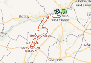
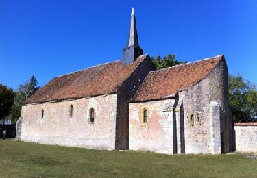
Tour Wandern von 12,7 km verfügbar auf Zentrum-Loiretal, Loiret, La Neuville-sur-Essonne. Diese Tour wird von fdpweb vorgeschlagen.
Beschreibung
13 km en boucle le long de la Rimarde avec une halte à mi-parcours ‘Aux Bons Vivres’, chouette endroit pour se restaurer.
Ort
Land:
France
Region :
Zentrum-Loiretal
Abteilung/Provinz :
Loiret
Kommune :
La Neuville-sur-Essonne
Standort:
Unknown
Gehen Sie:(Dec)
Gehen Sie:(UTM)
453585 ; 5337291 (31U) N.
Kommentare
Touren in der Umgebung
![Tour sport Briarres-sur-Essonne - Sob 3 briarres pithiviers - Photo](https://media.geolcdn.com/t/375/260/9e3b1338-0f3c-4e7b-b279-e44f47432ebb.jpg&format=jpg&maxdim=2)
Sob 3 briarres pithiviers
sport
Sehr leicht
Briarres-sur-Essonne,
Zentrum-Loiretal,
Loiret,
France
![](/images/other/stat-length.png)
23 km | 25 km-effort
Unbekannt
![](https://static1.geolcdn.com/siteimages/upload/files/16400158638029165_repeat_loop_refresh_sync_direction_icon.png)
Nein
![Tour Wandern Briarres-sur-Essonne - francorville - Photo](https://media.geolcdn.com/t/375/260/181d3973-4e6a-4e8e-bbea-e2572c76bff6.jpg&format=jpg&maxdim=2)
![Wandern Wandern](https://static1.geolcdn.com/sitytour/trail-icons/101.png)
francorville
Wandern
Sehr leicht
Briarres-sur-Essonne,
Zentrum-Loiretal,
Loiret,
France
![](/images/other/stat-length.png)
6,2 km | 6,9 km-effort
1h 18min
![](https://static1.geolcdn.com/siteimages/upload/files/16400158638029165_repeat_loop_refresh_sync_direction_icon.png)
Ja
![Tour Wandern Briarres-sur-Essonne - Orville - Photo](https://media.geolcdn.com/t/375/260/6f5426a8-05b6-4ddf-9947-c5696f949c08.jpg&format=jpg&maxdim=2)
![Wandern Wandern](https://static1.geolcdn.com/sitytour/trail-icons/101.png)
Orville
Wandern
Sehr leicht
Briarres-sur-Essonne,
Zentrum-Loiretal,
Loiret,
France
![](/images/other/stat-length.png)
4,5 km | 5,1 km-effort
1h 1min
![](https://static1.geolcdn.com/siteimages/upload/files/16400158638029165_repeat_loop_refresh_sync_direction_icon.png)
Ja
![Tour Wandern Yèvre-la-Ville - 2018-10-01 Rando Yèvre le Chatel - Photo](https://media.geolcdn.com/t/375/260/ext.jpg?maxdim=2&url=https%3A%2F%2Fstatic1.geolcdn.com%2Fsiteimages%2Fupload%2Ffiles%2F1553511878bg_sport_marche.png)
![Wandern Wandern](https://static1.geolcdn.com/sitytour/trail-icons/101.png)
2018-10-01 Rando Yèvre le Chatel
Wandern
Einfach
Yèvre-la-Ville,
Zentrum-Loiretal,
Loiret,
France
![](/images/other/stat-length.png)
19,1 km | 22 km-effort
4h 48min
![](https://static1.geolcdn.com/siteimages/upload/files/16400158638029165_repeat_loop_refresh_sync_direction_icon.png)
Ja
![Tour Wandern Yèvre-la-Ville - yevre LE chatel - Photo](https://media.geolcdn.com/t/375/260/ext.jpg?maxdim=2&url=https%3A%2F%2Fservices.sitytrail.com%2FGeolivesWS%2FDownloadMedia.ashx%3FTrailID%3D86406%26Media%3D20111002150505.jpg)
![Wandern Wandern](https://static1.geolcdn.com/sitytour/trail-icons/101.png)
yevre LE chatel
Wandern
Sehr leicht
Yèvre-la-Ville,
Zentrum-Loiretal,
Loiret,
France
![](/images/other/stat-length.png)
118 km | 134 km-effort
10h 40min
![](https://static1.geolcdn.com/siteimages/upload/files/16400158638029165_repeat_loop_refresh_sync_direction_icon.png)
Nein
![Tour Wandern Yèvre-la-Ville - Yevre le Chatel - Photo](https://media.geolcdn.com/t/375/260/ext.jpg?maxdim=2&url=https%3A%2F%2Fstatic1.geolcdn.com%2Fsiteimages%2Fupload%2Ffiles%2F1553511878bg_sport_marche.png)
![Wandern Wandern](https://static1.geolcdn.com/sitytour/trail-icons/101.png)
Yevre le Chatel
Wandern
Sehr schwierig
Yèvre-la-Ville,
Zentrum-Loiretal,
Loiret,
France
![](/images/other/stat-length.png)
18 km | 20 km-effort
4h 37min
![](https://static1.geolcdn.com/siteimages/upload/files/16400158638029165_repeat_loop_refresh_sync_direction_icon.png)
Ja
![Tour Wandern Yèvre-la-Ville - yevres - Photo](https://media.geolcdn.com/t/375/260/ext.jpg?maxdim=2&url=https%3A%2F%2Fstatic1.geolcdn.com%2Fsiteimages%2Fupload%2Ffiles%2F1553511878bg_sport_marche.png)
![Wandern Wandern](https://static1.geolcdn.com/sitytour/trail-icons/101.png)
yevres
Wandern
Sehr schwierig
Yèvre-la-Ville,
Zentrum-Loiretal,
Loiret,
France
![](/images/other/stat-length.png)
18,8 km | 21 km-effort
4h 37min
![](https://static1.geolcdn.com/siteimages/upload/files/16400158638029165_repeat_loop_refresh_sync_direction_icon.png)
Ja
![Tour Wandern Briarres-sur-Essonne - larris - Photo](https://media.geolcdn.com/t/375/260/ext.jpg?maxdim=2&url=https%3A%2F%2Fstatic1.geolcdn.com%2Fsiteimages%2Fupload%2Ffiles%2F1553511878bg_sport_marche.png)
![Wandern Wandern](https://static1.geolcdn.com/sitytour/trail-icons/101.png)
larris
Wandern
Einfach
Briarres-sur-Essonne,
Zentrum-Loiretal,
Loiret,
France
![](/images/other/stat-length.png)
5,6 km | 6,2 km-effort
1h 10min
![](https://static1.geolcdn.com/siteimages/upload/files/16400158638029165_repeat_loop_refresh_sync_direction_icon.png)
Ja
![Tour Wandern Briarres-sur-Essonne - spiraline - Photo](https://media.geolcdn.com/t/375/260/ext.jpg?maxdim=2&url=https%3A%2F%2Fstatic1.geolcdn.com%2Fsiteimages%2Fupload%2Ffiles%2F1553511878bg_sport_marche.png)
![Wandern Wandern](https://static1.geolcdn.com/sitytour/trail-icons/101.png)
spiraline
Wandern
Einfach
Briarres-sur-Essonne,
Zentrum-Loiretal,
Loiret,
France
![](/images/other/stat-length.png)
5,8 km | 6,3 km-effort
1h 10min
![](https://static1.geolcdn.com/siteimages/upload/files/16400158638029165_repeat_loop_refresh_sync_direction_icon.png)
Ja