![](/images/other/stat-length.png)
![Tour Wandern Vernet-les-Bains - dolmen - Corneilla de conflent -Fillol - Vernet les bains - Photo](https://media.geolcdn.com/t/1900/400/ext.pjpeg?maxdim=2&url=https%3A%2F%2Fmedia.geolcdn.com%2Ff%2F8ea3c90d-79d8-41aa-adae-4903f1ed0900.jpg)
dolmen - Corneilla de conflent -Fillol - Vernet les bains
Dadou 1
Benutzer
![Länge](/images/other/stat-length.png)
Länge
12,5 km
![Maximale Höhe](https://static1.geolcdn.com/siteimages/upload/files/1508320355ic_sort_altitude_max_24dp.png)
Maximale Höhe
843 m
![Positive Höhendifferenz](https://static1.geolcdn.com/siteimages/upload/files/1508320355ic_sort_den_pos_24dp.png)
Positive Höhendifferenz
443 m
![Km-Effort](/images/other/stat-length.png)
Km-Effort
18,4 km
![Min. Höhe](https://static1.geolcdn.com/siteimages/upload/files/1508320355ic_sort_altitude_min_24dp.png)
Min. Höhe
511 m
![Negative Höhendifferenz](https://static1.geolcdn.com/siteimages/upload/files/1508320355ic_sort_den_neg_24dp.png)
Negative Höhendifferenz
438 m
![Boucle](https://static1.geolcdn.com/siteimages/upload/files/16400158638029165_repeat_loop_refresh_sync_direction_icon.png)
Boucle
Ja
Erstellungsdatum :
2023-05-24 12:02:38.893
Letzte Änderung :
2023-05-24 15:26:27.655
![Wandern](https://static1.geolcdn.com/sitytour/trail-icons/101.png)
3h22
Schwierigkeit : Medium
![Scannen Sie diesen QR-Code, um die Tour in der SityTrail-Anwendung zu öffnen](https://capi.geolives.com/qq0zvz2zws4bq2lad0pu/sitytour/trails/3672181/qr.png?size=200)
Kostenlosegpshiking-Anwendung
Über SityTrail
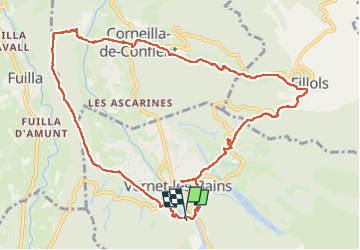
Tour Wandern von 12,5 km verfügbar auf Okzitanien, Ostpyrenäen, Vernet-les-Bains. Diese Tour wird von Dadou 1 vorgeschlagen.
Beschreibung
départ hôtel du Portugal
les Écuries- le dolmen - Corneilla de conflent - Fillol - Vernet les bains- hôtel du Portugal
Ort
Land:
France
Region :
Okzitanien
Abteilung/Provinz :
Ostpyrenäen
Kommune :
Vernet-les-Bains
Standort:
Unknown
Gehen Sie:(Dec)
Gehen Sie:(UTM)
449832 ; 4710395 (31T) N.
Kommentare
Touren in der Umgebung
![Tour Wandern Casteil - rando casteil du cady - Photo](https://media.geolcdn.com/t/375/260/ext.jpg?maxdim=2&url=https%3A%2F%2Fmedia.geolcdn.com%2Ff%2F352b0394-d6dc-4c9d-b4d3-5f316da4dd05.jpg)
![Wandern Wandern](https://static1.geolcdn.com/sitytour/trail-icons/101.png)
rando casteil du cady
Wandern
Sehr leicht
(1)
Casteil,
Okzitanien,
Ostpyrenäen,
France
![](/images/other/stat-length.png)
5,3 km | 8,7 km-effort
3h 16min
![](https://static1.geolcdn.com/siteimages/upload/files/16400158638029165_repeat_loop_refresh_sync_direction_icon.png)
Nein
![Tour Wandern Vernet-les-Bains - La tour de Goa - Photo](https://media.geolcdn.com/t/375/260/ext.jpg?maxdim=2&url=https%3A%2F%2Fservices.sitytrail.com%2FGeolivesWS%2FDownloadMedia.ashx%3FTrailID%3D109701%26Media%3D4392_3.jpg)
![Wandern Wandern](https://static1.geolcdn.com/sitytour/trail-icons/101.png)
La tour de Goa
Wandern
Schwierig
(2)
Vernet-les-Bains,
Okzitanien,
Ostpyrenäen,
France
![](/images/other/stat-length.png)
15,4 km | 31 km-effort
6h 30min
![](https://static1.geolcdn.com/siteimages/upload/files/16400158638029165_repeat_loop_refresh_sync_direction_icon.png)
Ja
![Tour Wandern Vernet-les-Bains - Cascade des Anglais à Vernet les Bains - Photo](https://media.geolcdn.com/t/375/260/ext.jpg?maxdim=2&url=https%3A%2F%2Fstatic1.geolcdn.com%2Fsiteimages%2Fupload%2Ffiles%2F1553511878bg_sport_marche.png)
![Wandern Wandern](https://static1.geolcdn.com/sitytour/trail-icons/101.png)
Cascade des Anglais à Vernet les Bains
Wandern
Schwierig
(1)
Vernet-les-Bains,
Okzitanien,
Ostpyrenäen,
France
![](/images/other/stat-length.png)
3,9 km | 6,6 km-effort
1h 34min
![](https://static1.geolcdn.com/siteimages/upload/files/16400158638029165_repeat_loop_refresh_sync_direction_icon.png)
Ja
![Tour Wandern Sahorre - Mattes rouges - Photo](https://media.geolcdn.com/t/375/260/ext.jpg?maxdim=2&url=https%3A%2F%2Fservices.sitytrail.com%2FGeolivesWS%2FDownloadMedia.ashx%3FTrailID%3D161092%26Media%3D20121103105150.jpg)
![Wandern Wandern](https://static1.geolcdn.com/sitytour/trail-icons/101.png)
Mattes rouges
Wandern
Medium
(1)
Sahorre,
Okzitanien,
Ostpyrenäen,
France
![](/images/other/stat-length.png)
11,5 km | 21 km-effort
4h 32min
![](https://static1.geolcdn.com/siteimages/upload/files/16400158638029165_repeat_loop_refresh_sync_direction_icon.png)
Ja
![Tour Wandern Taurinya - le Canigou depuis le col de Millères - Photo](https://media.geolcdn.com/t/375/260/ext.jpg?maxdim=2&url=https%3A%2F%2Fstatic1.geolcdn.com%2Fsiteimages%2Fupload%2Ffiles%2F1553511878bg_sport_marche.png)
![Wandern Wandern](https://static1.geolcdn.com/sitytour/trail-icons/101.png)
le Canigou depuis le col de Millères
Wandern
Schwierig
(1)
Taurinya,
Okzitanien,
Ostpyrenäen,
France
![](/images/other/stat-length.png)
22 km | 48 km-effort
8h 30min
![](https://static1.geolcdn.com/siteimages/upload/files/16400158638029165_repeat_loop_refresh_sync_direction_icon.png)
Ja
![Tour Wandern Fuilla - fuilla (66) - Photo](https://media.geolcdn.com/t/375/260/ext.jpg?maxdim=2&url=https%3A%2F%2Fmedia.geolcdn.com%2Ff%2F52a4cc98-58c8-4d12-9f81-88a2231fa3d3.jpg)
![Wandern Wandern](https://static1.geolcdn.com/sitytour/trail-icons/101.png)
fuilla (66)
Wandern
Schwierig
Fuilla,
Okzitanien,
Ostpyrenäen,
France
![](/images/other/stat-length.png)
11,7 km | 17,8 km-effort
5h 57min
![](https://static1.geolcdn.com/siteimages/upload/files/16400158638029165_repeat_loop_refresh_sync_direction_icon.png)
Ja
![Tour Wandern Corneilla-de-Conflent - Corneilla de Conflent - Photo](https://media.geolcdn.com/t/375/260/ext.jpg?maxdim=2&url=https%3A%2F%2Fmedia.geolcdn.com%2Ff%2F87184567-2ca4-4199-b850-a35026a3725a.jpg)
![Wandern Wandern](https://static1.geolcdn.com/sitytour/trail-icons/101.png)
Corneilla de Conflent
Wandern
Einfach
Corneilla-de-Conflent,
Okzitanien,
Ostpyrenäen,
France
![](/images/other/stat-length.png)
12,8 km | 17,7 km-effort
3h 27min
![](https://static1.geolcdn.com/siteimages/upload/files/16400158638029165_repeat_loop_refresh_sync_direction_icon.png)
Ja
![Tour Wandern Vernet-les-Bains - vernet tours de badabali - Photo](https://media.geolcdn.com/t/375/260/ext.jpg?maxdim=2&url=https%3A%2F%2Fmedia.geolcdn.com%2Ff%2Fcb56fc1d-584b-4a60-a4a1-cda4a3cc7c75.jpg)
![Wandern Wandern](https://static1.geolcdn.com/sitytour/trail-icons/101.png)
vernet tours de badabali
Wandern
Schwierig
Vernet-les-Bains,
Okzitanien,
Ostpyrenäen,
France
![](/images/other/stat-length.png)
12,5 km | 17,3 km-effort
6h 18min
![](https://static1.geolcdn.com/siteimages/upload/files/16400158638029165_repeat_loop_refresh_sync_direction_icon.png)
Ja
![Tour Wandern Vernet-les-Bains - plc de l'alzina départ chemin de la laiterie Vernet les Bains - Photo](https://media.geolcdn.com/t/375/260/ext.jpg?maxdim=2&url=https%3A%2F%2Fmedia.geolcdn.com%2Ff%2F340d308c-0d8c-4229-9e0f-cfbc8f15044e.jpg)
![Wandern Wandern](https://static1.geolcdn.com/sitytour/trail-icons/101.png)
plc de l'alzina départ chemin de la laiterie Vernet les Bains
Wandern
Medium
Vernet-les-Bains,
Okzitanien,
Ostpyrenäen,
France
![](/images/other/stat-length.png)
7,8 km | 12,4 km-effort
2h 32min
![](https://static1.geolcdn.com/siteimages/upload/files/16400158638029165_repeat_loop_refresh_sync_direction_icon.png)
Ja